 Hiking Upper Muley Twist
Burr Trail
Overview
|
Thu 67 | 46 |
Fri 63 | 46 |
Sat 59 | 40 |
Sun 68 | 39 |
Mon 74 | 43 |
| View Full Weather Details | ||||
|
Thu 67 | 46 |
Fri 63 | 46 |
Sat 59 | 40 |
Sun 68 | 39 |
Mon 74 | 43 |
| View Full Weather Details | ||||
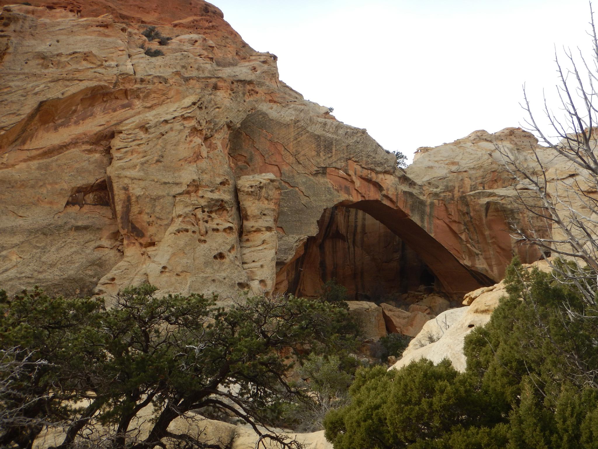
First arch in Upper Muley Twist
Arches, a slot canyon, big views, and an intricate route, I think Upper Muley Twist has a bit of everything an excellent desert adventure can offer. The route is a good one and reminds me of Devils Garden in Arches National Park.
The hiking is straightforward though a bit of route finding and a fair bit of exposure in a few spots makes this an outing best suited to those which a bit of experience. I would NOT recommend this hike to those with a fear of heights!
The reward of this hike is an excellent day in Capitol Reef, visiting 7+ arches en route to the end of Upper Mulley Twist Canyon, which ends in a stunning slot section you won't want to miss. Alas, the slot is impassable from the bottom, and an intricate bypass winds its way around the obstacle to where the trail heads east for stunning views of Strike Valley, the Henry Mountains, and the many buttes in between as it loops back to the trailhead. A very memorable and magnificent day.
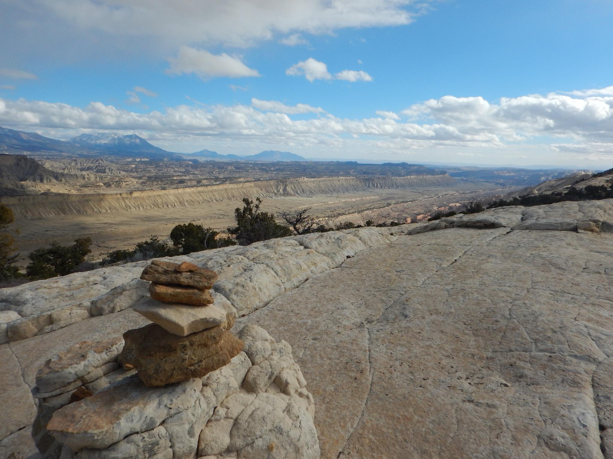
Rim Route Views
Getting There
Via Notom
Travel east out of Capitol Reef National Park on Highway 24. Just past the park, 0.25 miles, is the well signed Notom road. Head south on the Notom road 32.6 miles to the Cedar Mesa Campground on the right (west) side of the road. Along the way, at 13.6 miles, is the Sandy Creek Junction. Stay right on the Notom road here. At 32.6 is a junction and well signed Burr Trail.
Go right on the Burr Trail. It quickly climbs switchbacks behind the reef. Follow it for 3.1 miles to the signed Upper Muley Twist road on the right.
Via Boulder
If coming from Boulder, UT, turn onto the Burr Trail on the south side of town. Follow the Burr Trail road 32.8 miles to a junction with a lesser used side road to the Upper Muley Twist trailhead. If you reach the Lower Muley Twist trailhead or the road drops steeply down switchbacks, you have gone too far.
From the Burr Trail Road
From the Burr Trail Road, follow the 2-track dirt road north. Immediately to the east on the skyline is Peek-a-boo rock, which has an arch near the top that is visible from certain angles. After 0.4 miles a small parking area and trail register are reached. If you are in a 2wd and have gotten this far, this is likely the best place to stop. From here the road descends steeply into the wash and begins following the wash upstream.
After 2.4 miles of wash walking, Double Arch is visible on the left.
Continue to the end of the road at 2.9 miles. There is a small parking area here, and the Strike Valley Overlook trail leaves the parking area heading due east.
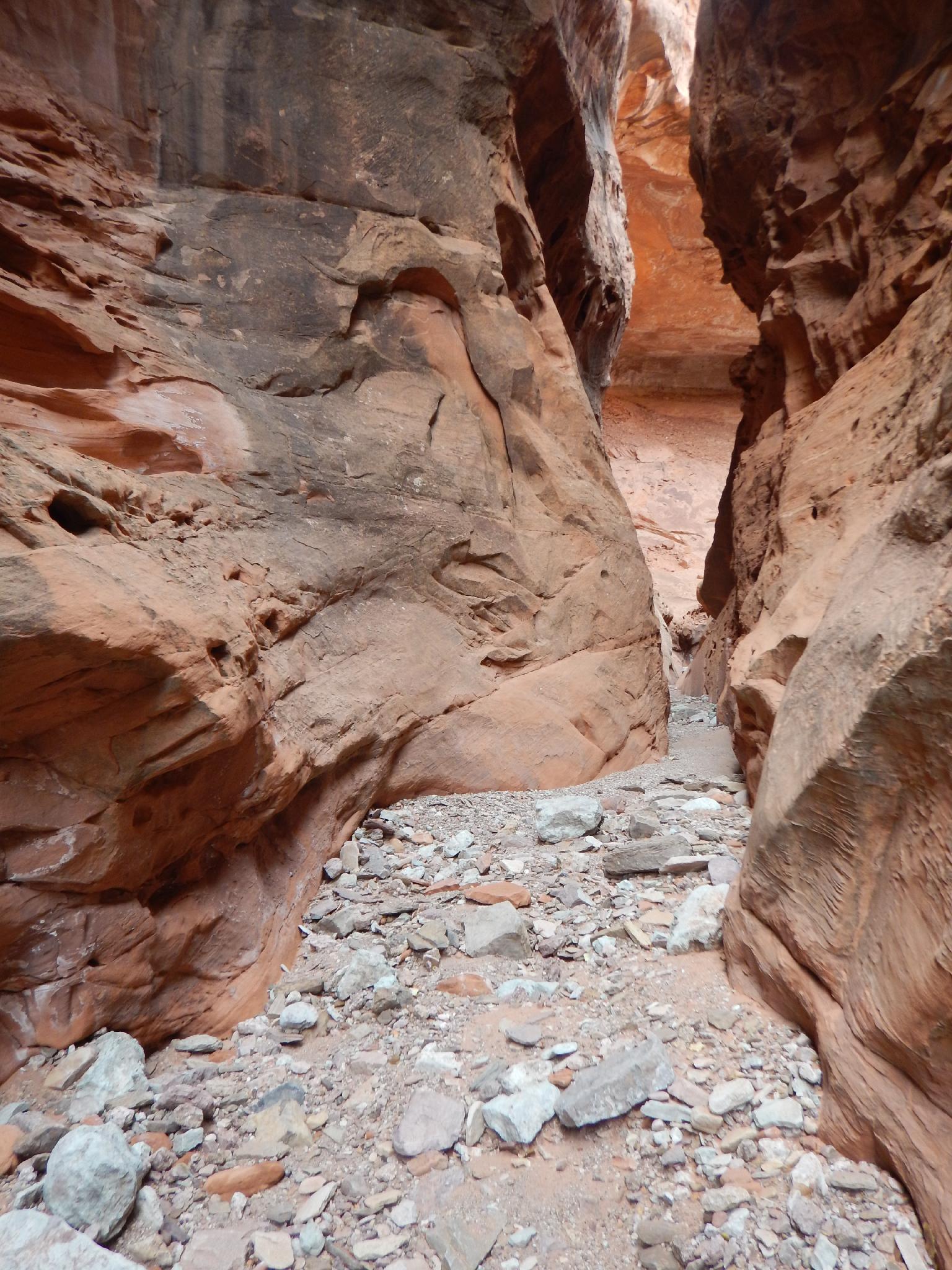
The narrows in Upper Muley Twist
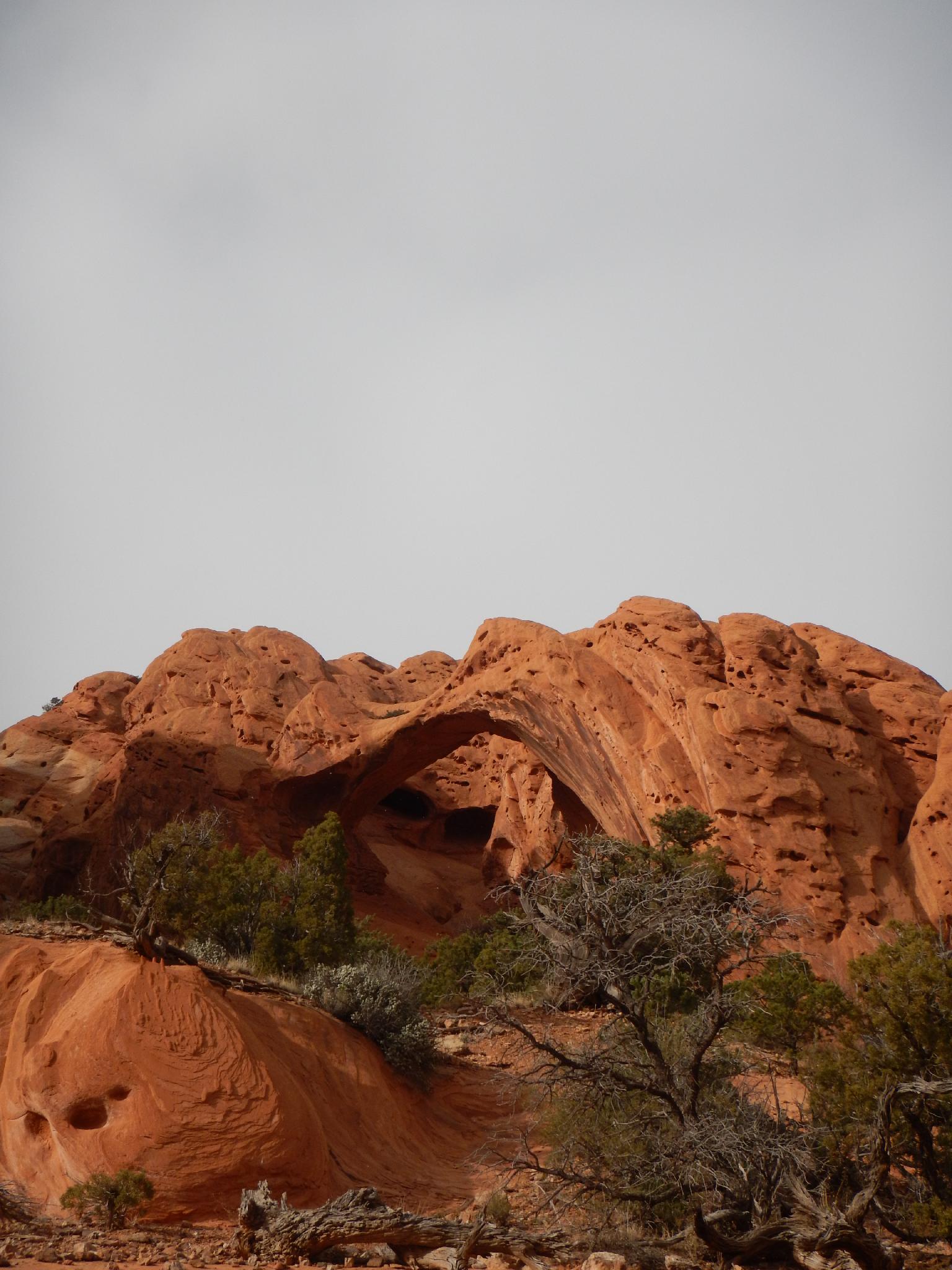
Saddle Arch in Upper Muley Twist
Route
From the trailhead, follow the wash north. It is well travelled as easy to follow. It branches 10 or so minutes from the trailhead. Be sure to go right here, as the wash heads into a slickrock canyon. Not far past this junction the first arch is encountered on the left. It is impressive, but seemingly unnamed. Continuing up the canyon it is not far to the named Saddle Arch on the left. Saddle Arch is an important landmark, as the loop trail rejoins the approach trail here on the exit.
The colors and canyon keep getting better and better. Stay in the bottom of the wash and continue hiking up Upper Muley Twist. Three more arches present themselves though I saw at least one more arch high on the slopes as well. A side canyon comes in on the left with an arch at its mouth at ground level. This side canyon is an important landmark. A few minutes up the main drainage, the slot bypass leaves on the right and is decently cairned. If you miss it, you will end up in a deep dark slot. Reverse to where the slot opens to find the bypass on the east (right looking up canyon) side.
Hiking into the slot it quickly deepens and becomes well sculpted, dark, and extremely photogenic. Continue up a few minutes to a dryfall with a pool at the bottom. This dryfall is a good turnaround spot for most groups.
Climbers and very experienced desert rats can get around this dryfall via a set of moki steps on the right (looking up canyon) just before the dryfall. These are quite shallow and tricky. Not recommended except for the very experienced. BE SURE YOU CAN REVERSE ANYTHING YOU GO UP!
Above the moki steps, re-enter the canyon bottom and continue up. The canyon widens and comes to a junction. Go right, passing by another set of moki steps on the right shortly. (These provide a very difficult and exposed exit. NOT RECOMMENDED.) Continue up a few more minutes to another slot section. Just up from the entrance of this second slot is a dryfall that will stop all upward progress, and a bit of graffiti painted on the right wall. Return the same way.
The bypass is well cairned and climbs a fair bit before traversing up along the rim of Upper Muley. There are several very exposed sections here, be careful! The bypass eventually re-enters the canyon bottom as Upper Muley Twist Canyon opens. Continue up a few minutes, and the Rim Route is reached. The Rim Route is signed, and relatively hard to miss. The trail leaves Upper Muley Twist Canyon here and heads east, working its way east to the rim and outstanding views of Strike Valley, and the Henry Mountains.
The Rim Route is very well cairned, but be sure not to get caught up in the scenery and forget to look for cairns! The route meanders along the rim before descending and re-entering Upper Muley Twist right at Saddle Arch. Turn left here and retrace your route back down to the trailhead.
Photos
Maps


| Trailhead (2wd) |
12S 496565mE 4190096mN N37° 51' 30" W111° 02' 21" |
| Trailhead (4wd) |
12S 495894mE 4192676mN N37° 52' 54" W111° 02' 48" |
| Right |
12S 495078mE 4194179mN N37° 53' 42" W111° 03' 21" |
| Arch |
12S 494913mE 4194533mN N37° 53' 54" W111° 03' 28" |
| Saddle Arch |
12S 494772mE 4194923mN N37° 54' 07" W111° 03' 34" |
| Arch |
12S 494174mE 4195875mN N37° 54' 37" W111° 03' 59" |
| Arch |
12S 493882mE 4196273mN N37° 54' 50" W111° 04' 11" |
| Arch |
12S 493547mE 4197069mN N37° 55' 16" W111° 04' 24" |
| Bypass |
12S 493541mE 4197205mN N37° 55' 21" W111° 04' 25" |
| Rim Route Junction (North) |
12S 493136mE 4198202mN N37° 55' 53" W111° 04' 41" |
| Canyon Route Sign (North) |
12S 493396mE 4197978mN N37° 55' 46" W111° 04' 31" |
| Canyon Route Sign (South) |
12S 495030mE 4194752mN N37° 54' 01" W111° 03' 23" |
| Rim Route Junction (South) |
12S 494783mE 4194892mN N37° 54' 06" W111° 03' 34" |