 Hiking Upper Escalante River
Escalante
Overview
|
Fri 77 | 48 |
Sat 75 | 47 |
Sun 80 | 48 |
Mon 81 | 50 |
Tue 80 | 48 |
| View Full Weather Details | ||||
|
Fri 77 | 48 |
Sat 75 | 47 |
Sun 80 | 48 |
Mon 81 | 50 |
Tue 80 | 48 |
| View Full Weather Details | ||||
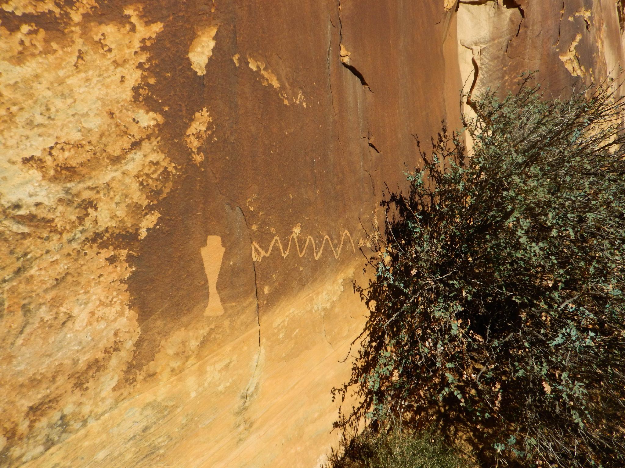
First petroglyph panel
Few hikes off such a bang for their buck as the Upper Escalante River hike. Starting near the town of Escalante, the hike quickly enters a deep Navajo sandstone canyon that it follows for almost 15 miles along the Escalante River to the Highway 12 bridge. En route, 2 petroglyph panels, a pictograph panel, an impressive alcove, and more stunning scenery that you can shake your wading stick at are encountered.
The full hike is about 15 miles, depending on how you cut the bends. This is commonly done as a casual overnight backpack or long day hike. Those looking for a shorter outing or even a family friendly outing can't go wrong just doing an out and back from the Escalante River Trailhead. Visiting the 3 panels and returning makes for a very reasonable 6-mile outing.
The hike can be done spring through fall, though spring runoff will make the river too high to safely cross at times. I would recommend 50 cfs or less. You will be in the river or crossing often, so bring good wading shoes and be sure it is warm enough your feet won't freeze.
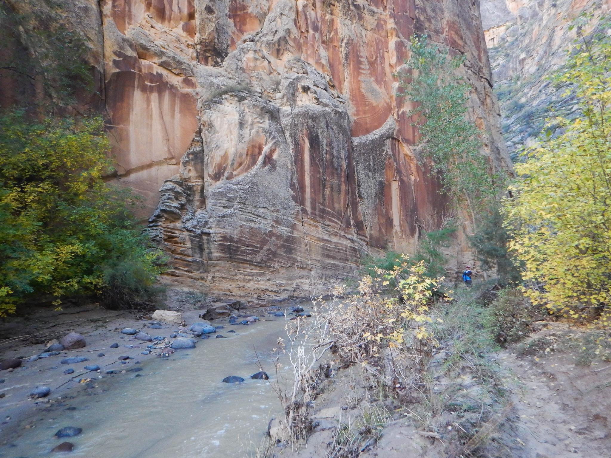
The upper Escalante! Very Zion like in places.
Getting There
Exit Trailhead (Highway 12 Bridge)
From Escalante, go east on highway 12 toward Boulder. About 14 miles out of Escalante, just after crossing the bridge over the Escalante River (MP 73.9), turn left (west) to a parking area and trailhead. This is just a couple of miles BEFORE the Calf Creek campground.
Trailhead (Escalante River Trailhead)
On the east side of the town of Escalante, turn north at the cemetery. Instead of going into the cemetery, go right on the road as it follows the perimeter of the cemetery, then heads east. Take the first left in about 0.4 miles and follow the slightly rougher road 0.6 miles to the trailhead and a parking area on the left.
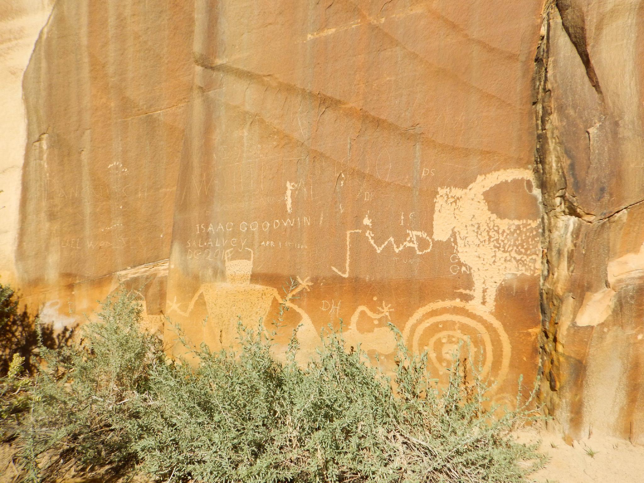
The second petroglyph panel.
Route
Rock art and historic sites are fragile, non-renewable cultural resources that, once damaged, can never be replaced. To ensure they are protected, please:
- Avoid Touching the Petroglyphs: Look and observe, BUT DO NOT TOUCH!
- Stay on the Trails: Stay on the most used trails when visiting sites, and don't create new trails or trample vegetation.
- Photography and Sketching is Allowed: Do not introduce any foreign substance to enhance the carved and pecked images for photographic or drawing purposes. Altering, defacing, or damaging the petroglyphs is against the law -- even if the damage is unintentional.
- Pets: Keep pets on a leash and clean up after them.
- Artifacts: If you happen to come across sherds (broken pottery) or lithics (flakes of stone tools), leave them where you see them. Once they are moved or removed, a piece of the past is forever lost.
Visiting the Panels (3.2 miles one way / 1.5 hours)
From the trailhead, follow the road down the hill to the gate, where it turns into a single track. The trail quickly descends to the Escalante River in a half mile. Once at the river, don't worry about getting your feet wet. It is bound to happen, so just get them wet early! Trails abound on both sides of the river, pick whichever looks best to you and follow it.
Not far down the river, a side drainage comes in, then the gaging station is reached. From the gaging station, the river makes a slight left bend, then a right bend, then a deeper left bend with towering walls. The first petroglyph panel is on the left here, and easy to spot. Stay on the main trail on the north side of the river and you should spot it. (1.6 miles from the trailhead)
The river bends again to the right, then on the next left bend is the second petroglyph panel. Again, easy to spot as long as you stay on the north side trail.
The third panel, a pictograph, skips the next left-hand bend and shows up in the one after. This one is very hard to miss. It is in the back of the grand alcove that could house scores of people. To the alcove is about 3.2 miles from the trailhead.
To Death Hollow (7.7miles from the trailhead)
Continuing down from the alcove, the canyon settles into a rhythm of bends and meanders, ever deepening. The next major landmark is Death Hollow that comes in on the left. This is easy to spot, with its generally clear stream coming in and several excellent campsites. If backpacking, this area is about 1/2 way with good camping and the water in Death Hollow is usually fairly clear to filter. If time allows, exploring up Death Hollow is an excellent afternoon hike or even layover day.
To The Arch (4.6 miles from Death Hollow)
Unfortunately below Death Hollow, the Tamarisk and Russian Olive are very thick. There is an ongoing effort to remove this invasive species from the Escalante, but this stretch is currently very overgrown (2016). Lower in the canyon you will likely see large cut piles where eradication efforts have been focused. In many spots, it is easier to wade in the river than try and fight through the brush along the side. Fortunately, after a mile or two, this lessens and the going gets easier. After 4.6 miles / 2 hours, an arch high on the right wall comes into view.
Just past the arch, look for old ruins above the river on the south side. The social trail visits them.
To The Bridge (2 miles)
From the ruins, the trail becomes better used. It is a short distance to the Escalante Natural Bridge, an impossible to miss natural bridge on the right (south side) of the canyon. A 5-minute side trip visits this from underneath and is highly recommended. Leaving the Escalante Natural Bridge, the trail is wide, well worn, and goes quickly. The highway 12 bridge is reached after a few more river crossings. If you go under a highway bridge, you've gone too far!
Photos
Maps
")
")
| Trailhead |
12S 449097mE 4180224mN N37° 46' 05" W111° 34' 41" |
| Fence |
12S 448964mE 4180624mN N37° 46' 18" W111° 34' 46" |
| Gauge |
12S 449403mE 4181335mN N37° 46' 41" W111° 34' 28" |
| Petroglyph Panel |
12S 449699mE 4181804mN N37° 46' 56" W111° 34' 16" |
| Petroglyph Panel 2 |
12S 449959mE 4181937mN N37° 47' 00" W111° 34' 06" |
| Arch View (High north) |
12S 450588mE 4181680mN N37° 46' 52" W111° 33' 40" |
| Alcove and Pictograph |
12S 450860mE 4181764mN N37° 46' 55" W111° 33' 29" |
| Death Hollow |
12S 455497mE 4181618mN N37° 46' 51" W111° 30' 19" |
| Arch View |
12S 460167mE 4180883mN N37° 46' 28" W111° 27' 08" |
| Ruin and Panel |
12S 460420mE 4180898mN N37° 46' 28" W111° 26' 58" |
| Escalante Natural Bridge |
12S 460839mE 4180668mN N37° 46' 21" W111° 26' 41" |
| Exit Trailhead |
12S 463057mE 4181035mN N37° 46' 33" W111° 25' 10" |