 Climbing Monticello Butte
Moab
Overview
|
Wed 82 | 53 |
Thu 74 | 52 |
Fri 69 | 48 |
Sat 63 | 44 |
Sun 68 | 42 |
| View Full Weather Details | ||||
|
Wed 82 | 53 |
Thu 74 | 52 |
Fri 69 | 48 |
Sat 63 | 44 |
Sun 68 | 42 |
| View Full Weather Details | ||||

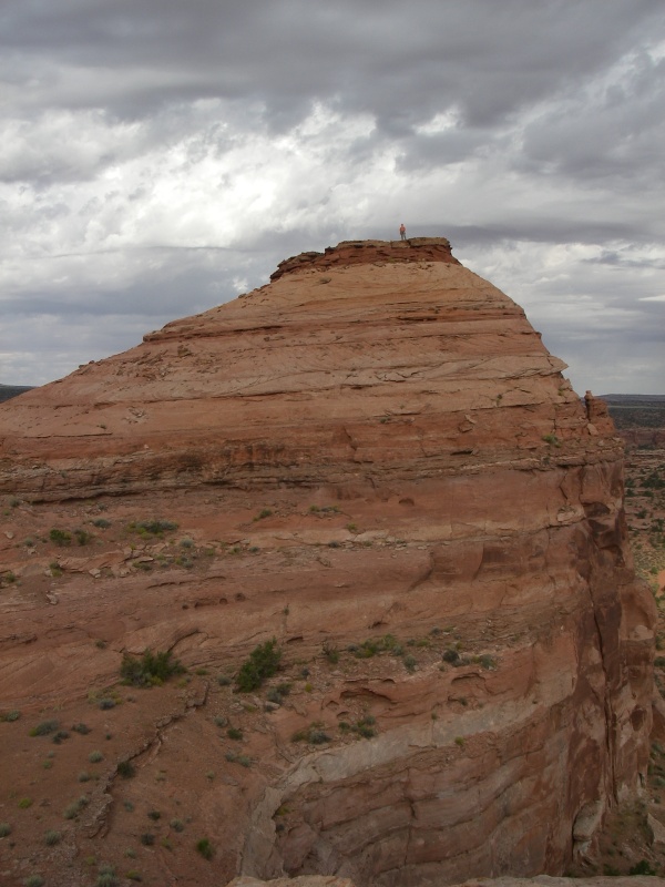
Monticello Butte
Thumbing through Desert Rock 4 toward the end of a climbing weekend in Moab, I spied Monticello Butte. A surprisingly moderate route at 5.7, it had a 4-star rating and seemed perfect for ending the weekend. The climbing didn't seem 4-star to either Jim or I, but the views are pretty incredible.
Summit of Monticello Butte

Monticello Route
Getting There
Getting to Monticello Butte requires a high clearance vehicle. The last mile or so is very rough 4x4 road. We parked within sight of the butte, but didn't make the last 1/2 mile or so drive due to the roughness of the road.
Head North on the highway out of Moab toward I-70. From the Colorado River bridge, reset your odometer.
- About 7 miles from the bridge, turn left (west) onto the signed Gemini Bridges road. ( 12S 615118mE 4279456mN / N38° 39' 22" W109° 40' 37" )
- Stay on the main Gemini Bridges road for 4.7 miles to the signed Gold Bar Rim junction. Right goes up a steep hill and to Gemini Bridges. You go left here instead, following a wash, then exiting up a steep hill. ( 12S 615501mE 4273230mN / N38° 36' 00" W109° 40' 25" )
- Monticello Butte is visible at the top of this hill, and is less than a mile or so from the Gold Bar Rim / Gemini Bridges junction. This stretch of road is very rough, and may need to be walked unless you have a real 4x4 or disregard for your vehicle. ( 12S 616477mE 4273000mN / N38° 35' 52" W109° 39' 45" )
Route
September 16, 2007
Climbers: Ryan Cornia and Jim Schnepal
Written By: Ryan Cornia
Pitch 1:
The climb starts on the west side. It is easily identified as a slot with a bush about half way up. The slot is low angled and easy until you reach a bulge about 3/4 of the way up. This is where I placed gear, chimneyed over the bulge, and then it is easier ground to a crack up high where you can get gear in for a belay.
After this pitch, it is an easy scramble to the west summit. The summit has some amazing views. Reaching the east summit requires a bit of easy, but unprotected lower 5th class climbing (and down climbing).
Getting Down:
The guide book described a long, 2-rope overhanging rappel to get off. While this is an option off the south/west side, we found slings on a tree on the north/east side of the formation. This provides an easy rappel and only requires one rope. The rap is 25 m ( 83 ft. ) or so.
Although I found the climbing uninspiring, the views are well worth it, and it is a truly moderate summit to get on top of in the desert. Enjoy!
Photos
Maps

| Base of Route |
12S 616709mE 4272786mN N38° 35' 45" W109° 39' 35" |