
 Painted Rocks
Yuba Lake State Park
Overview
|
Sun 59 | 33 |
Mon 68 | 35 |
Tue 67 | 34 |
Wed 58 | 36 |
Thu 62 | 31 |
| View Full Weather Details | ||||
|
Sun 59 | 33 |
Mon 68 | 35 |
Tue 67 | 34 |
Wed 58 | 36 |
Thu 62 | 31 |
| View Full Weather Details | ||||
Painted Rocks - Yuba Lake State Park
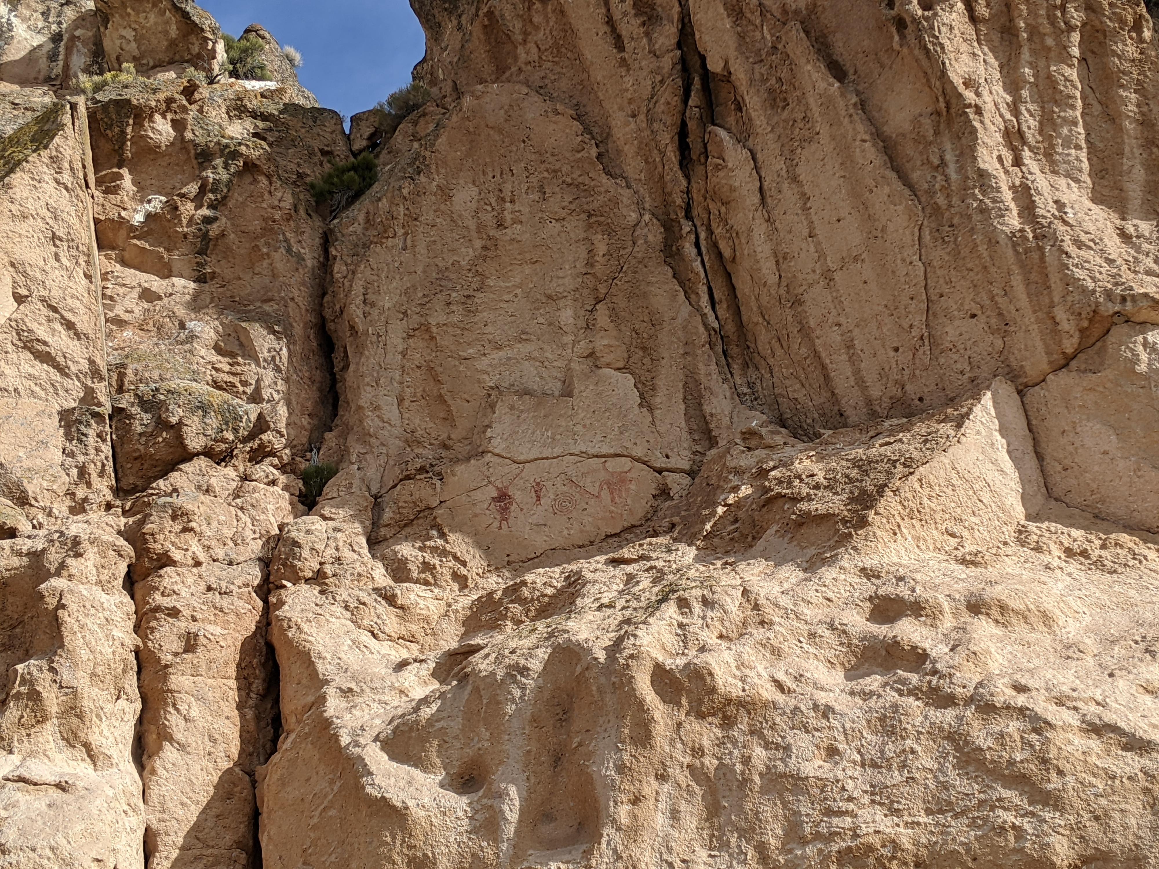
Yuba Lake State Park is popular with anglers, boaters, and many ATV enthusiasts visiting to ride the trails that surround the lake. There are few opportunities for hiking at Yuba Lake, aside from wandering along the seashore. There is a social trail above Painted Rocks that has great views of the lake. At low waters, it is possible to walk out to the base of Painted Rocks and visit a pictograph panel. The panel, on the south face of Painted Rocks, is quite stunning. The difficult to access location of the panel has helped keep it from vandalism.

Interesting hollowed out caves at low water.
Getting There
From Nephi, go south on UT-28 toward Levan. At Levan (about 10 miles south of Nephi) turn left to state on UT-28 signed Gunnison. 14.5 miles south of Levan is Yuba Lake State Park on the right. After entering the park, continue to the end of the road at the Painted Rocks Boat Ramp.
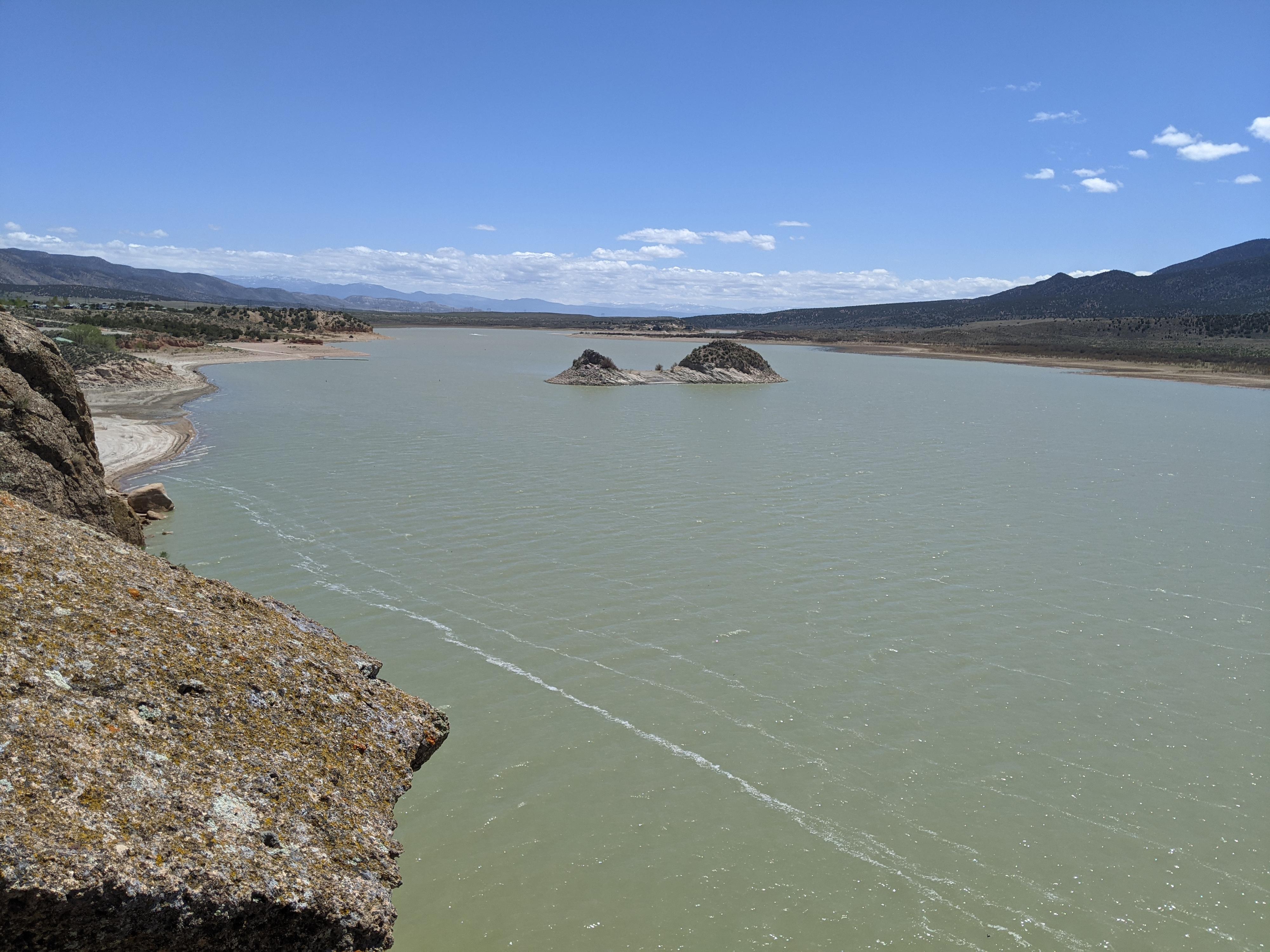
Upper Painted Rocks at higher spring water levels.
Route
Rock art and historic sites are fragile, non-renewable cultural resources that, once damaged, can never be replaced. To ensure they are protected, please:
- Avoid Touching the Petroglyphs: Look and observe, BUT DO NOT TOUCH!
- Stay on the Trails: Stay on the most used trails when visiting sites, and don't create new trails or trample vegetation.
- Photography and Sketching is Allowed: Do not introduce any foreign substance to enhance the carved and pecked images for photographic or drawing purposes. Altering, defacing, or damaging the petroglyphs is against the law -- even if the damage is unintentional.
- Pets: Keep pets on a leash and clean up after them.
- Artifacts: If you happen to come across sherds (broken pottery) or lithics (flakes of stone tools), leave them where you see them. Once they are moved or removed, a piece of the past is forever lost.
Painted Rocks Panel View
In low water, simply follow the shoreline west along the base of Painted Rocks. The initial cliff band has several hollowed-out caves and small passages. Continue along for about 1/3 of a mile from the trailhead. The panels are visible high on the vertical rock face and quite easy to spot once your eye catches them.
Painted Rocks Upper Hike
From the trailhead, cross over the possibly wet area to the base of Painted Rocks. A social trail climbs steeply here. Follow it up a couple of minutes to a few large boulders. Go left at the boulders as the social trail contours west along Painted Rocks using a ledge about halfway between Yuba Lake and the top of Painted Rocks. The social trail meanders along until a prominent junction. The junction is a good turning-round spot or go right and climb up and to a dirt road and overlook.
Photos
Maps

| Panel View |
12S 418017mE 4356893mN N39° 21' 27" W111° 57' 06" |
| Trail |
12S 418189mE 4356823mN N39° 21' 25" W111° 56' 58" |
| Boulders |
12S 418183mE 4356896mN N39° 21' 28" W111° 56' 59" |
| Jct |
12S 417803mE 4357304mN N39° 21' 41" W111° 57' 15" |
| Dirt Road |
12S 417803mE 4357414mN N39° 21' 44" W111° 57' 15" |
| Trailhead |
12S 418393mE 4356625mN N39° 21' 19" W111° 56' 50" |