 Floating
Labyrinth Canyon
Floating
Labyrinth Canyon
Green River
Overview
"There is an exquisite charm in our ride to-day down this beautiful canyon. It gradually grows deeper with every mile of travel; the walls are symmetrically curved and grandly arched, of a beautiful color, and reflected in the quiet waters in many places so as almost to deceive the eye and suggest to the beholder the thought that he is looking into profound depths."
-John Wesley Powell, Canyons of the Colorado
I can think of no better introduction to Labyrinth Canyon than the imagery Powell conjures up in his description of Labyrinth Canyon when he and his men floated the Green River in 1869. He and his men named this picturesque canyon.
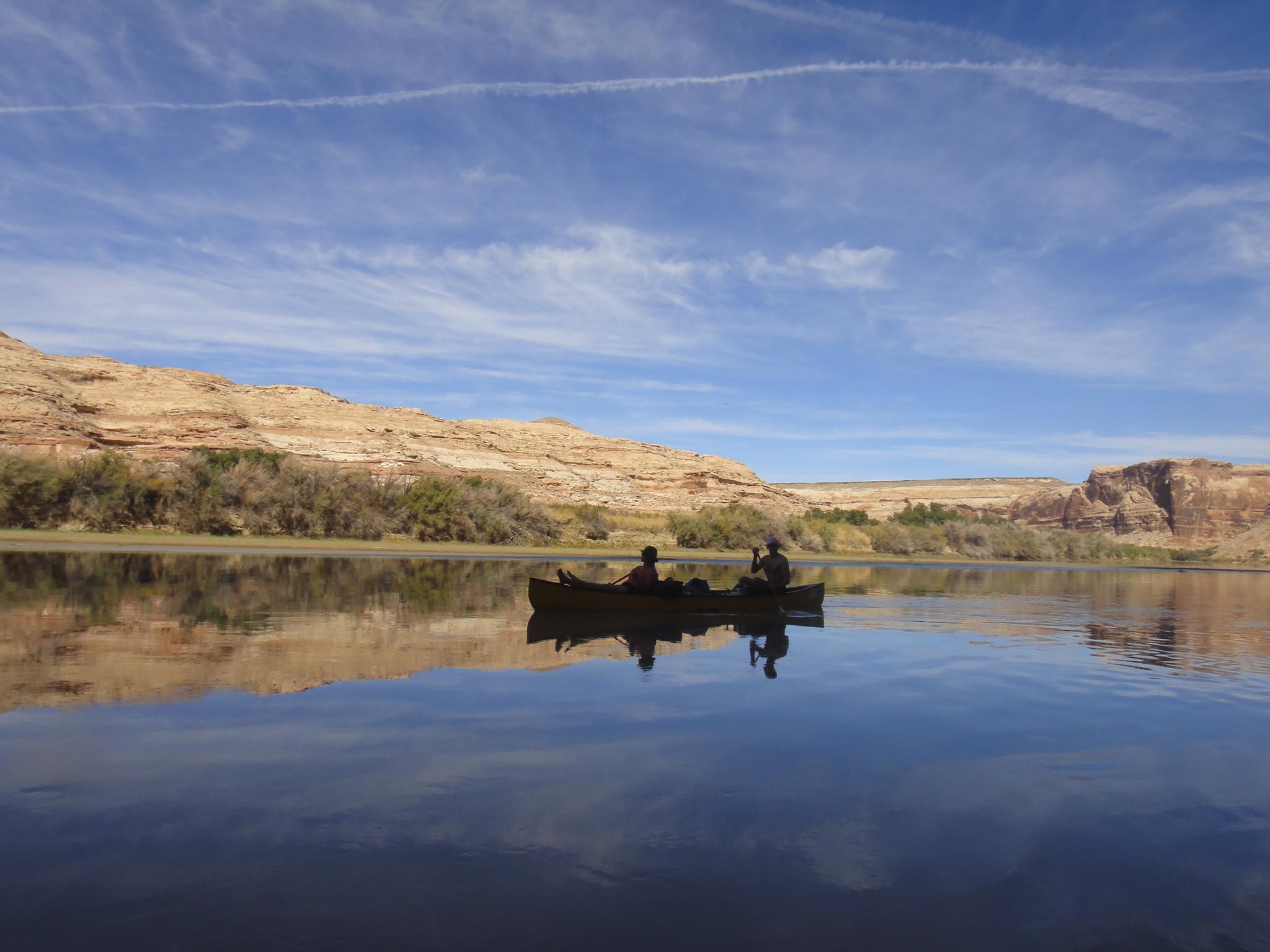
Floating the Green River through Labyrinth Canyon is one of my absolute favorite trips. Though a class I float that more hardcore boaters might consider "boring", the scenery of the float more than makes up for the lack of rapids in my opinion. This may be the best family-friendly river trip in Utah filled with scenery, history, and a lazy meandering river.
The trip is, however, a bit of an endeavor. It is commonly floated from the town of Green River to Mineral Bottom, as a 68-mile trip, or from Ruby Ranch to Mineral Bottom as a 45-mile trip. I would recommend 3 days as a minimum if starting at Ruby Ranch, and 4+ if starting from Green River. The canyon lends itself to lazy afternoons at camp and a leisurely pace.
Season
Spring
Floating in April, May can be pleasant, and usually before the bugs start to come out. Flows often start to rise in mid-May to peak flows by the end of May or the first part of June. In my experience, up canyon winds can be worst in the spring. Once water levels rise, finding paths through the tamarisk for a place to camp is challenging and not fun.
Summer
June, July, and August are my least favorite times to be on the river. Afternoon heat can be a bit miserable if not on the river, but more-so can be the bugs. On my first July trip, the bugs were so bad when not in the middle of the river floating, we paddled from Green River to Mineral Bottom in about 30 hours, stopping when it got dark to sleep, but otherwise trying to stay away from shore and the bugs! Like spring, high flows make finding camping spots harder. By mid to late summer, the flows drop enough to find good sandbars and banks to camp on.
Fall
September and early to mid-October are my preferred season. Nice temps, still fairly long days, and fewer or no bugs make this a charming time to be on the river. The lower river levels mean sandy beaches and islands to camp on, but lower flows can mean for long floating days (or more paddling).
Winter
Not advised to float in winter. At least one group has ended up stranded when they found the river iced completely over mid-way through. The road down to Mineral Bottom can be impassable at times in the winter as well.
Notes
- Canoes are the most common way to float Labyrinth, and what I recommend. Easy, fast, and a great way to experience the canyon.
- Rafts, duckies, and other inflatables are also commonly used, but generally slower than canoes because of resistance in the water. I used a cataraft one spring trip, and enjoyed the extra space, but used canoes on all other trips.
- Motors are allowed in Labyrinth, and I have run into one or two motorized rafts on my trips, but they are pretty uncommon. The group we ran into was struggling in the low water with the motor constantly dragging.
- On all of my trips, float time seems to average about 3 miles an hour if not paddling much. On early spring trips, with higher/faster water, this has also meant stronger winds, slowing down overall mileage. Fall trips I have found a slower river, but less wind. For planning, 3 miles per hour has worked well for me.
- Bugs can be horrendous at certain times. Bring bug spray.
- The river water is very silty. Either bring all you need with you (recommended) or some way to remove silt before filtering (like alum).
- If water is high and sandbar/island camping isn't available, often the best places to get through the tamarisk seems to be at the start or end of the hollows. I have also had good luck landing the boat at the end of a side canyon and walking upstream a ways to find a place out of the tamarisk.
- Pick a campsite well before dark! On a couple of occasions, I left finding a campsite too long and ended up settling for a bad spot in the tamarisk as darkness was fast approaching...
Getting There
Starting Points
The float can be started in Green River (68 mile float) or Ruby Ranch (48 mile float). I have done most of my trips from Green River, and one trip from Ruby Ranch. I generally prefer Green River with the first day floating to just before Labyrinth Canyon and camping on a sandbar.
Green River
Starting in Green River has the pros of the shuttle being a bit easier (with less dirt road), and saving a few bucks on using the private Ruby Ranch Launch. One con of starting in Green River is the extra 20 miles is not particularly scenic compared to the lower 48 miles. The other main con is that before Ruby Ranch the land is mostly private, making finding a place to camp difficult. If starting at Green River, plan on floating at least past Ruby Ranch to find camping the first night.
The Green River launches are either Green River State Park (as of 2019, a $5 day use fee and $5 per night to leave a vehicle at the boat ramp) or putting in at the bridge over the Green River in downtown Green River on the I-70 Business Loop. (free, but no long term parking)
Ruby Ranch
Ruby Ranch is the other common starting point. It requires a bit of good dirt road to reach the ranch, and a fee to park and launch from the private ranch. In 2019, the fee was $10 per boat AND $5 per person. Most start at Ruby Ranch because the river quickly enters Labyrinth Canyon below Ruby Ranch and is all public land once in the canyon.
To reach Ruby Ranch, take exit 175 from I-70 and head south off the highway. This is about 10 miles east of the city of Green River. Once off the highway, head south on the dirt road and reset your odometer:
- 7.4 miles - Turn left. This is BLM #147.
- 12.9 miles - Junction, stay right on Ruby Ranch Road.
- 14.9 miles - After going around a field, the road reaches a junction at the edge of fields. Go right here and follow the road as it curves around the field.
- 15.5 miles - Stay left as the road continues around the field and heads southwest to the river and a parking spot.
- 16 miles - The put-in and parking spot.
Ending Point
Most Labyrinth Canyon trips end at Mineral Bottom. Just below Mineral Bottom, the river enters Canyonlands National Park. Permits are required for all overnight trips in Canyonlands National Park as well as a jet boat shuttle back up from the confluence to Moab.
Mineral Bottom is reached from Highway 313, the highway to Canyonlands Island In the Sky. From the junction of 191 and 313, go west on 313 about 13 miles to a well signed Mineral Bottom Road on the right. Follow this good gravel road 15 miles. It steeply descends switchbacks to the river. At the bottom of the switchbacks, stay right to reach the put in.
I've done my own shuttle on some of my trips. It is time-consuming to set up, and a hassle. A list of current shuttles is available on Discover Moab. I now use a shuttle on all trips to save time and hassle. It is more enjoyable to spend several hours floating on the Green than driving cars back and forth.
Route Description
Below are the main attractions that I recommend with river mile estimates on the map. River miles (RM) marked on the map are approximate from the confluence of the Green River and Colorado.
- RM 121 - Green River Put-in on the river right.
- RM 120 - State Park Put-In on the river right
- RM 115.5 - Crystal Geyser river left. This geyser is a remnant of an old drilling exploration that hit a pocket of soda. These days the geyser is quite unpredictable. You can stop here but are unlikely to see the geyser erupt, it generally only erupts ever 24+ hours. The area is easy to spot, as colorful flow stone comes down to the edge of the river.
- RM 97.1 - Ruby Ranch on the river left
- RM 97 - San Rafael River enters on the river right
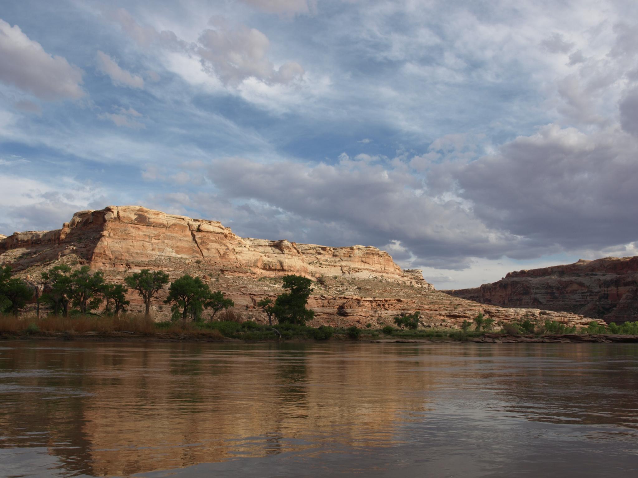
- RM 90 - Three Canyon on the river right. The bend is called Trin Alcove Bend and was named by Powell. Three Canyon is the start of Labyrinth Canyon. Hiking up the bottom of Three as a day hike is an excellent outing. Camping at the mouth is very popular and recommended if a spot is open.
- RM 88.5 - Junes Bottom is on river right. This is a somewhat difficult place to visit because of the tamarisk. On our visit, at the next bend (RM 88) there were a couple of paths through the tamarisks at a sandbar that allowed easy access to Junes Bottom. Once through the tamarisk, cattle and other trails make walking back up to their old place easy.
History: Junes Bottom is named after June Marsing, who, with his wife Edith and their three children, lived in the bottom from 1933 to 1936. There is a spring and some small ruins of their place as shown on the map. They lived in a rather lovely spot to my eye, with big trees and a meadow nearby. There is an old road, shown as a track on the map, that climbs a steep slick rock and dirt slope out of the bottom that they used to reach their place. The track is still easy to find and follow for a bit, and has outstanding views down to the river. If camping at the sandbar near RM88, this is an excellent side hike.
- RM 80.5 - Ten Mile Canyon comes in on the river left. A popular lunch spot on my trips.
- RM 79 - Keg Spring Canyon comes in on the river right. Seldom trod, the bottom of the canyon is easy walking and quite pretty. It is more open than Three Canyon.
- RM 77.5 - River Register on the river left. This is an interesting place for a break. DO NOT ADD YOUR NAME. The old names are historic and fascinating. Your name would just be adding graffiti and it is illegal!
- RM 75.8 - Hey Joe Canyon on the river left. A popular spot to stop for a short hike. Just up canyon from the river is the site of Hey Joe Mine. This is an old Uranium and Vanadium mine.
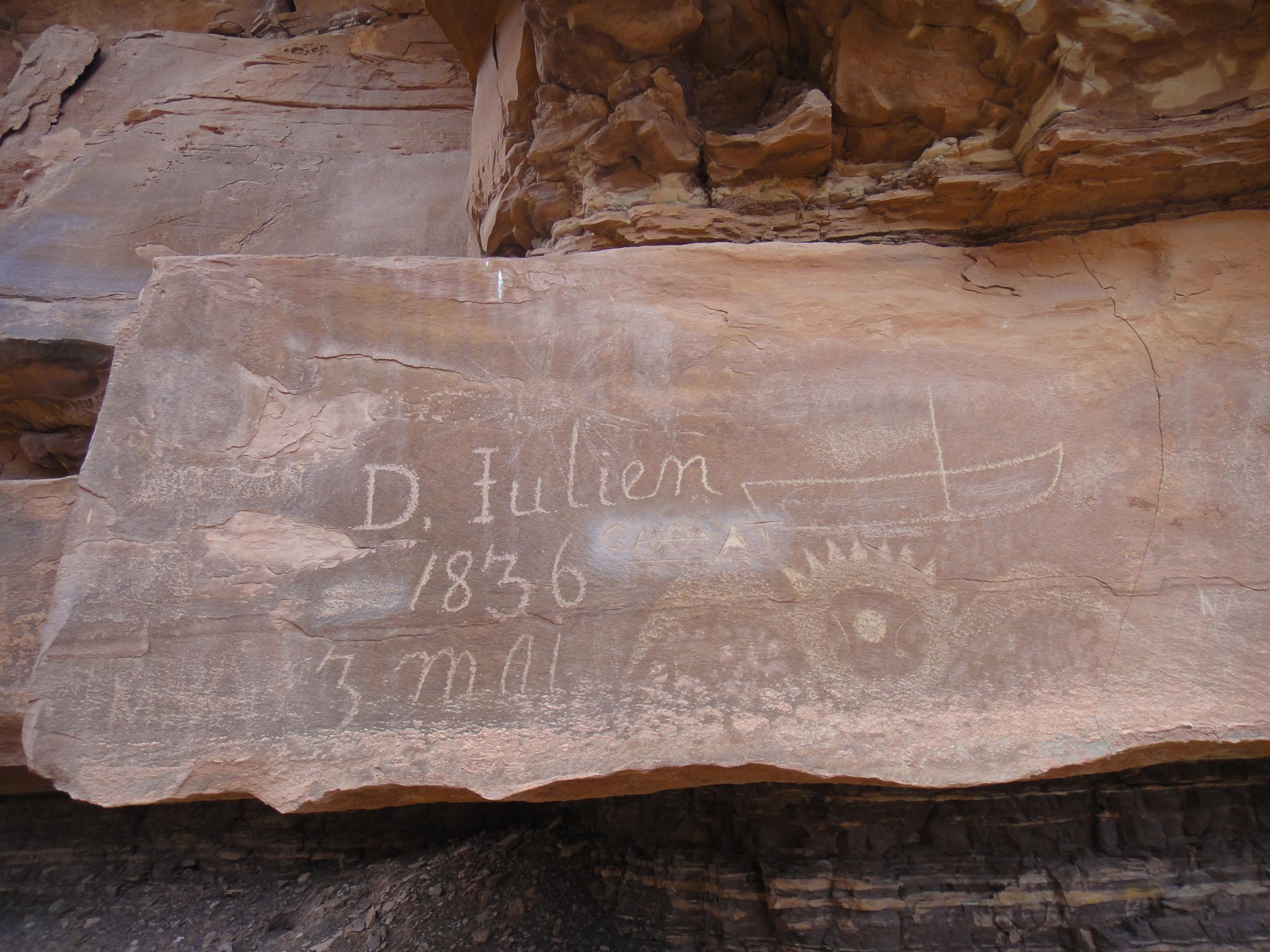
- RM 74.9 - D. Julien Signature on river left. Denis Julien was a fur trapper born in 1772. You can find his inscriptions in several places in Utah and one in Colorado. He would have been one of very few Europeans in the area at that time. Most of his signatures are from the 1830s, making him in his late 50s or early 60s when traveling the area. Some of his inscriptions include the depiction of a sail. It is assumed he used a sail at times when navigating the Green and Colorado Rivers. The inscription is between the river and the old dirt road above it, where the old dirt road goes up and over a small hill.
- RM 73.3 -Launch Marguerite is a prominent sign painted on the rock cliff above the river on the river left.
History: Marguerite was a wooden boat owned by Tom Wimmer, that was about 33 feet long and 7 feet wide. It was named after one of his daughters. Wimmer used the boat on the Green River from 1907 to 1915. Apparently, in 1909, on one of his trips, he decided to leave the inscription.
- RM 69.7 - The beginning of the river's loop around Bowknot Bend. The river makes a sweeping 8-mile bend to arrive less than a half of a mile south.
A social trail goes from the river (river right) to the notch that separates the river and makes a great side trip. It well defined, including some rock steps. Be sure to stay on the trail. The saddle has amazing views of the bend.
You can hike down to the river on the other side as well making a 3/4 mile hike that cuts off 8 miles of floating (if someone in your group will float the boat around the bend!).
History Note: From the saddle, if you go west (away from Bowknot Bend) to the cliff face, there are quite a few historical signatures. A few of the signatures are from the early 1900s. One, Georgie White, is from October 26, 1947. Georgie was the first woman to row Marble and Grand Canyons in 1952. - RM 67.5 - Spring Canyon comes in on the river left. A road comes down Spring Canyon and parallels the river here.
- RM 60.8 - Two Mile Canyon comes in on the river right.
- RM 59.2 - Horseshoe Canyon comes in on the right. The end of the float is only 7 miles away. If camping a final night, decent camping can often be found here. Below Horseshoe, I have not found any good campsites. Horseshoe is a big canyon and makes a great hike if you are motivated.
- RM 55.5 - Hell Roaring Canyon on river left. There is a second D. Julien signature on the rocks a short distance up from the river on the right (north facing) wall.
- RM 52.1 - Mineral Bottom Takeout on river left.
Photos
Maps
")
")
")
")


12S 574159E 4316496N
38°59'40"N 110°08'37"W
12S 573588E 4315863N
38°59'19"N 110°09'01"W
12S 574907E 4310270N
38°56'17"N 110°08'09"W
12S 577733E 4292443N
38°46'38"N 110°06'18"W
12S 577652E 4292297N
38°46'34"N 110°06'22"W
12S 576169E 4284543N
38°42'22"N 110°07'26"W
12S 578056E 4285049N
38°42'38"N 110°06'08"W
12S 581384E 4279551N
38°39'39"N 110°03'53"W
12S 581940E 4277920N
38°38'46"N 110°03'30"W
12S 583205E 4279498N
38°39'37"N 110°02'37"W
12S 583245E 4277362N
38°38'27"N 110°02'36"W
12S 583394E 4275406N
38°37'24"N 110°02'31"W
12S 582128E 4274703N
38°37'01"N 110°03'24"W
12S 584624E 4273747N
38°36'30"N 110°01'41"W
12S 587072E 4275021N
38°37'10"N 109°59'59"W
12S 581906E 4271074N
38°35'04"N 110°03'35"W
12S 583687E 4269690N
38°34'18"N 110°02'22"W
12S 588518E 4268886N
38°33'50"N 109°59'02"W
12S 587779E 4264511N
38°31'29"N 109°59'35"W
12S 584044E 4273496N
38°36'22"N 110°02'05"W
12S 573607E 4315734N
38°59'15"N 110°09'00"W
12S 575029E 4309598N
38°55'56"N 110°08'04"W
12S 572416E 4305877N
38°53'56"N 110°09'54"W
12S 574771E 4301039N
38°51'18"N 110°08'18"W
12S 577648E 4295902N
38°48'30"N 110°06'20"W
12S 579771E 4290059N
38°45'20"N 110°04'55"W
12S 576282E 4284644N
38°42'26"N 110°07'22"W
12S 579146E 4281885N
38°40'55"N 110°05'24"W
12S 582164E 4279516N
38°39'38"N 110°03'20"W
12S 582891E 4276107N
38°37'47"N 110°02'52"W
12S 584168E 4273881N
38°36'34"N 110°01'60"W
12S 586690E 4271505N
38°35'16"N 110°00'17"W
12S 582895E 4270427N
38°34'42"N 110°02'54"W
12S 587910E 4268089N
38°33'25"N 109°59'28"W
12S 587503E 4264396N
38°31'25"N 109°59'46"W