 Roadside Attraction
Mule Canyon Interpretive Site
Roadside Attraction
Mule Canyon Interpretive Site
Highway 95
Overview
If you are passing by on Highway 95 between Hanksville and Blanding, the Mule Canyon Interpretive Site is an excellent stop. The site was studied and stabilized in the 1970s. With its rooms, kiva, and history, it is a very fascinating stop to visit.
From the information signs at the site:
BASKETMAKER II (A.D. 1–500)
The earliest Anasazi are named Basketmakers because they made baskets of extremely high quality. These were often decorated with geometric designs, and some were resin-treated or so tightly woven that they were waterproof.
The earliest habitation and storage structures found in the Southwest were built during this period. These were circular “pithouses” built with log walls over saucer-shaped depressions. They did not contain interior fireplaces. The Basketmaker II stored food by digging pits in cave floors, sometimes lining them with rock slabs. Basketmaker II groups hunted and gathered on the mesas year-round, and farmed corn and squash near the streams during the summer. The spear and atlatl (spear thrower) were used for hunting. Digging sticks were used for farming. Dogs were the only domestic animal.
Clothing consisted of skirts or breechclouts and yucca sandals. In winter they wore robes or blankets made by wrapping strips of rabbit fur around heavy strings made from yucca fiber. The Basketmaker II buried their dead in caves, wrapping the bodies in robes.
BASKETMAKER III (A.D. 500–750)
The Basketmaker III people were more settled and learned to make pottery containers, more useful than baskets for cooking and storage. Pots were made by pinching and scraping clay coils to form smooth vessel walls. Most Basketmaker III pottery was plain grayware, but some bowls had black designs reminiscent of those on the earlier baskets.
Basketmaker III people built deep pithouses with a post-supported roof and interior fireplace having an air deflector and ash pit. The sipapu, a small hole in the pithouse floor, represented the sacred hole where ancestral spirits had emerged from the underworld.
Dryland farming was developed during this period, allowing the location of homesites on the mesa tops, away from the canyon rims. Hunting and gathering continued, and the spear thrower was gradually replaced by the bow and arrow. Arrows were tipped with pointed hardwood or finely chipped stone points.
ANASAZI
The Anasazi, a Navajo word meaning the "ancient ones" or "ancient enemy'', occupied the Four Corners area for over 1300 years. Starting about the time of Christ, they progressed from hunting and gathering to a more settled lifestyle. Several phases marked this change, visible in the architecture, agriculture and implements.
PUEBLO I (A.D. 750-900)
In the Pueblo I period, pottery making improved. Painted orange and red wares were made, and flat clay bands sometimes decorated the necks of gray vessels. By this time, loom weaving and cotton textiles had been introduced, and the Pueblo I people produced cotton ponchos and blankets.
Surface structures for dwelling and storage became common. Villages, some fairly large, were constructed with rectangular rooms of stone masonry, as well as sticks and mud mortar.
The addition of beans as a food crop added protein to their diet and perhaps improved their health. Use of the cradleboard for carrying small children is evident from the skull deformation found on Anasazi skeletons from this period on.
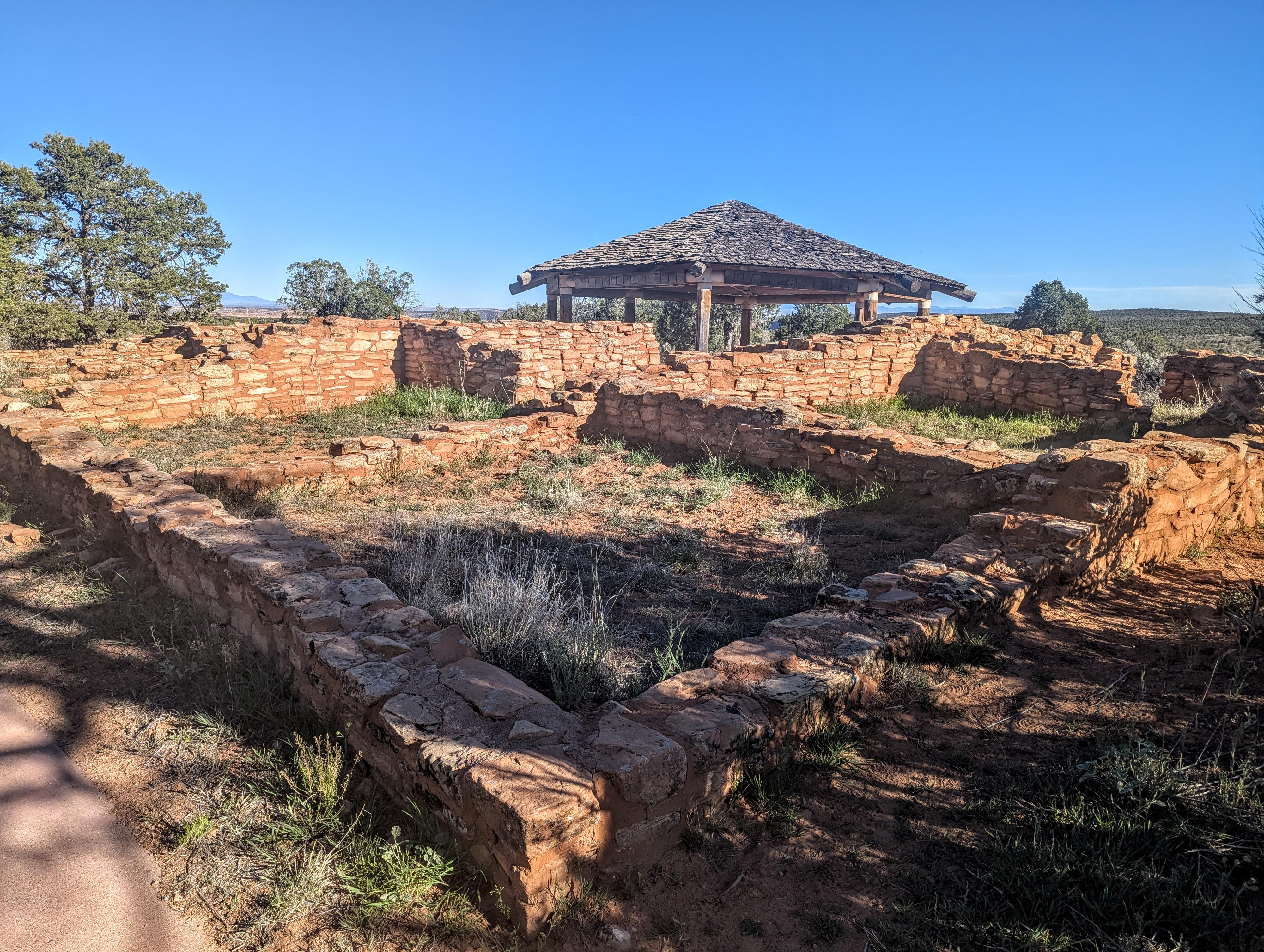
Mule Canyon Ruin
Mule Canyon Ruin is an open Anasazi habitation site consisting of both above- and below-ground structures. This site was first occupied briefly in the Pueblo I time period (about A.D. 750) but the main occupation was during the Pueblo II and Pueblo III transition period (about A.D. 1000 to 1150). The readily visible L-shaped block of 12 rooms and the masonry kiva and tower were connected by two crawlways (tunnels). A subterranean pithouse, dirt-walled kiva, and trash areas were also found.
The room block was used by two or three family groups primarily for sleeping and storage. They entered through roof hatchways with ladders, as well as through doorways. During good weather, cooking and other daily activities took place on the roof or in the plaza.
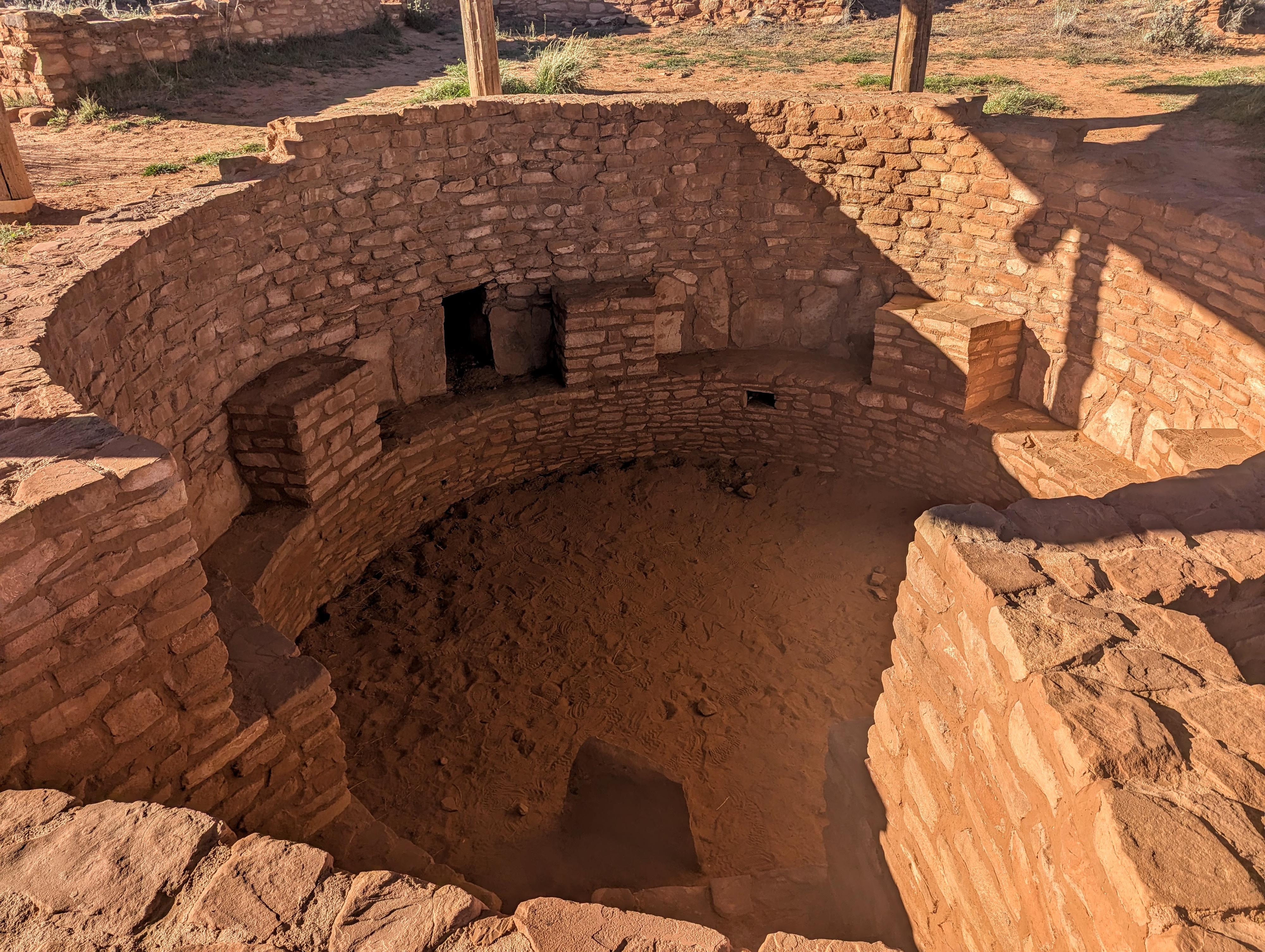
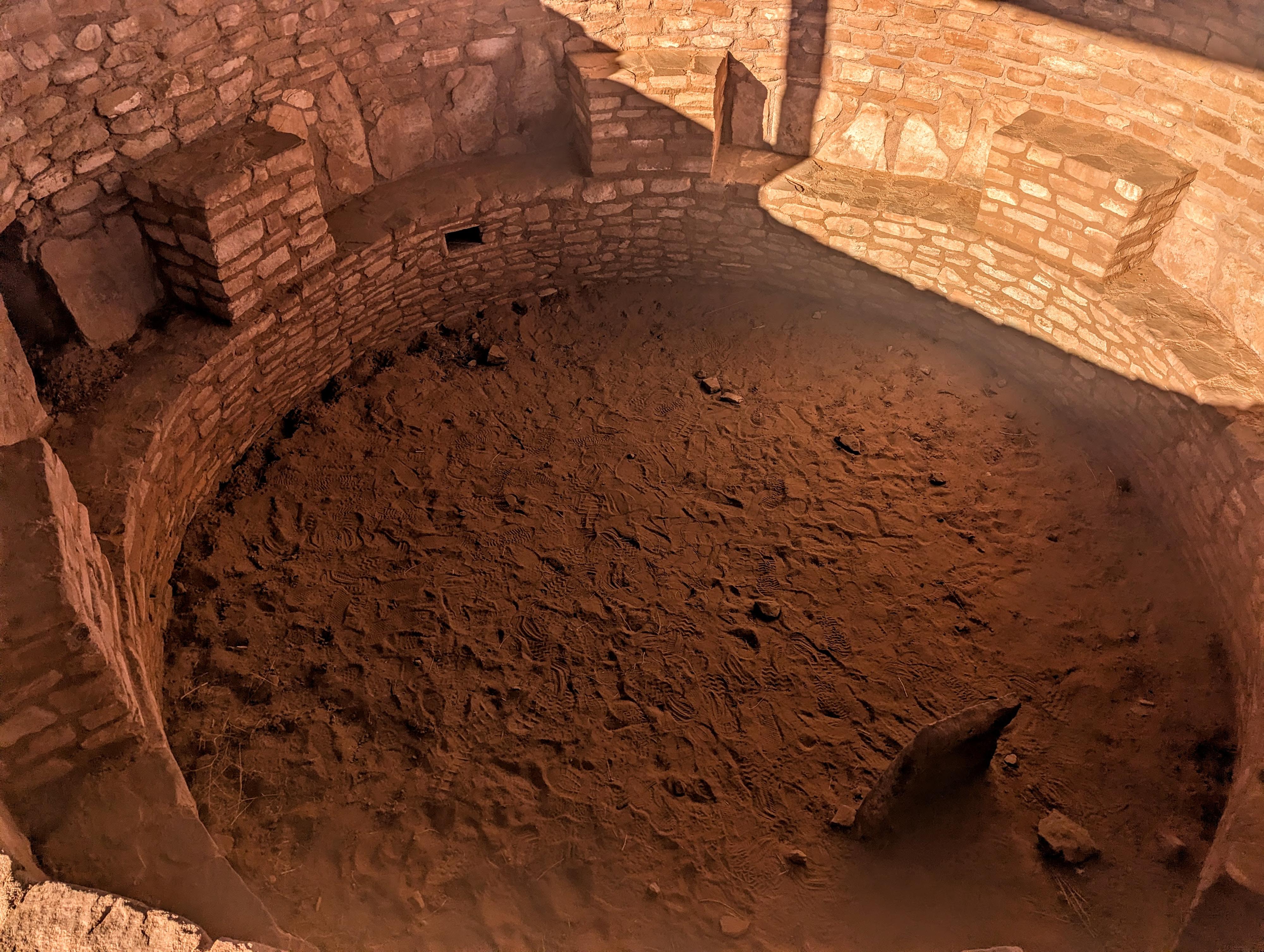
The underground kiva was a focal point for ceremonial activities. From studying contemporary Pueblo Indians, descendents of the Anasazi, archaeologists believe that these ceremonies were reserved primarily for males. The kiva was roofed over with logs (usually juniper), then covered with earth. Access into this kiva was through a hole in the roof using a ladder, as well as by tunnels which are uncommon in the area.
The circular tower was probably two stories high when in use. It's function is unknown, but may have been solar observation, defense, communication, or storage. The linkage of towers to kivas by tunnels may indicate the tower was used for ceremonial practices. Mule Canyon Ruin is in direct line of sight with Cave Towers, one mile to the southeast, which may mean the towers were used for signalling between the two communities.
Botanical studies have shown that corn, beans, and squash were the staple foods. These were supplemented with a variety of wild plant and animal foods. Pottery and architecture from this site indicate a strong influence from the Mesa Verde subculture of the Anasazi from southwest Colorado. However, the Kayenta subculture influence from northwest Arizona is also apparent in numerous pottery fragments. Butler Wash Ruin, located six miles to the east, has a square kiva, which also indicates a Kayenta influence.
Because of its proximity to the highway and its excellent preservation, Mule Canyon Ruin was selected as an interpretive rest stop and developed through the cooperative efforts of county, state and federal governments. In 1973 archaeologists from the University of Utah excavated the site, giving special attention to the structures and the trash areas. The ruin was stabilized by the National Park Service in 1973 & 1974. The Utah Department of Transportation constructed the parking loop, and the Bureau of Land Management built the kiva's protective roof, the trails and the rest rooms. San Juan County helped fund this interpretive display.
We hope you enjoy your visit here; please treat this site with respect so that others can also appreciate it. Remember that archaeological resources such as Mule Canyon Ruin are protected by both Federal and State laws. Please do not deface the site or remove any arti- facts, no matter how small. We need your help to protect and preserve our Southwest heritage.
Getting There
The site is at mile marker 101.4 on UT-95 that runs between Hanksville and Blanding. This is 101.4 miles east of Hanksville, or about 24 miles west of Blanding.
Route Description
From the trailhead, the trail makes a loop of the ruin with informational signs near the kiva.
Maps

12S 611086E 4155519N
37°32'24"N 109°44'33"W
12S 611141E 4155443N
37°32'21"N 109°44'31"W