 Floating
Ruby and Horsethief Canyons
Floating
Ruby and Horsethief Canyons
Colorado River
Overview
Looking for a casual family float trip? Ruby / Horsethief provides a very mellow 25-mile float with one rapid, generally considered class II. This is a good trip for beginners or families. Aside from the one rapid, and short section of turbulent water, the other 24 miles is very easy and relaxing. The scenery is second to none, with ample opportunity for side hikes.
The flow should be BELOW 30,000 CFS for rafts. For those in a canoe, less than 20,000 CFS if experienced, less than 10,000 CFS if inexperienced. For family trips, lower is better. Note that afternoon winds can slow down the trip greatly.
Tips for Camp Selection
If you want to camp among the ancient black metamorphic rock walls, target Black Rocks 1 through 9. They fill up fast on Recreation.gov because they offer incredible swimming and are very scenic. We camped at Black Rock 4 and thought it was exceptional.
For hiking, Rattlesnake (Mile 3.2), Mee Canyon (Mile 13.6), and Knowles (Mile 18.3) are the undisputed kings if your primary goal is to do some hiking. These canyons offer excellent hiking opportunities.
Days on the River
During spring flows, some float the entire section in one long day. In medium to low flows, this would be difficult and require a lot of paddling. I think most do the trip as a two-day, one-night trip. If you want to hike, or if flows are low, I would recommend a 3-day, two-night trip. As always, afternoon winds can greatly slow progress.
Approximate Miles
0.0 Loma Boat Launch
3.2 Rattlesnake (River Left) Right at the mouth of Rattlesnake Canyon; great access for the arch hikes.
3.5 Beaver Tail 1 (River Right) Cobblestone landing, little to no shade. Tricky landing at high water.
3.6 Beaver Tail 2 (River Right) Close neighbor to BT1.
3.7 Bull Draw (River Left) Located just past the Beaver Tail area.
5.6 Banjo Camp (River Left) Sits just above the Cottonwood complex.
5.8 Cottonwood 1 (River Left) The Cottonwood sites share a large bench with mature trees.
5.9 Cottonwood 2 (River Left) Standard bench site; popular for shade.
6.0 Cottonwood 3 (River Left) Part of the main Cottonwood grouping.
6.1 Cottonwood 4 (River Left) Good staging area for smaller or mid-sized rafts.
6.2 Cottonwood 5 (River Left) Nice shade, lots of trees; last of the Cottonwood complex.
7.9 Salt Creek 1 (River Left) Smaller footprint, quieter stretch of the river.
8.0 Salt Creek 2 (River Left) Grassy landing with decent shade.
10.3 Fault Line 1 (River Left) Small site, grass landing. Can be tough to spot/land at high flows.
10.5 Fault Line 2 (River Left) Just downstream from FL1. Near where the train tracks run close.
12.7 Mee Corner (River Left) Cobblestone/sand beach landing; nicely separated from the main Mee sites.
13.1 Mee 1 (River Left) First of the closely grouped Mee Bench sites.
13.2 Mee 2 (River Left) Part of the Mee Bench; great canyon views.
13.3 Mee 3 (River Left) Standard Mee Bench site.
13.4 Mee 4 (River Left) Last numbered Mee site before the main canyon mouth.
13.6 Mee Canyon (River Left) Prime real estate. Best direct access for hiking into the massive Mee Canyon system.
14.7 Dog Island (Island) Good sand landing just below the Mee complex.
15.8 Split Rock (River Left) Sits right above the entrance to the Black Rocks section.
16.0 Black Rocks 1 (River Left) Start of the iconic, deeply sculpted 1.7-billion-year-old Vishnu Schist.
16.1 Black Rocks 2 (River Left) Beautiful dark rock formations, very popular.
16.2 Black Rocks 3 (River Left) Highly sought-after for the unique geology and deep water.
16.4 Black Rocks 4 (River Left) Mid-complex Black Rocks site.
16.5 Black Rocks 5 (River Left) Great for swimming/lounging on the flat black rock shelves.
16.6 Black Rocks 6 (River Left) Excellent scenery and deep river staging.
16.7 Black Rocks 7 (River Left) Lower end of the Black Rocks complex.
16.8 Black Rocks 8 (River Left) Quiet site near the exit of the schist formations.
17.0 Black Rocks 9 (River Left) Last Black Rocks site. Great access to the Moore Canyon/Canyon Rim hikes.
18.1 Island Camp (Island) Just past Black Rocks, easy big-boat landing.
18.3 Knowles (River Left) Excellent access for exploring the long Knowles Canyon side hike.
20.3 May Flats (River Right) Wide open bench on river right; close to the UT/CO border.
25.0 Westwater Ranger Station - Takeout (River Right)
Getting There
Put-In
Take the Loma exit (exit 15) off I-70 just inside Colorado. Go south off the highway, making an immediate left at the T. The boat ramp and parking is less than a mile from this junction.
Take-out
Travel back into Utah on I-70 for about 5 miles to the Westwater exit. (Exit 227). Travel south off the highway for about 9 miles to the ranger station, picnic area, and boat ramp.
The shuttle takes about 45 minutes each way.
Route Description
Rock art and historic sites are fragile, non-renewable cultural resources that, once damaged, can never be replaced. To ensure they are protected, please:
- Avoid Touching the Petroglyphs: Look and observe, BUT DO NOT TOUCH!
- Stay on the Trails: Stay on the most used trails when visiting sites, and don't create new trails or trample vegetation.
- Photography and Sketching is Allowed: Do not introduce any foreign substance to enhance the carved and pecked images for photographic or drawing purposes. Altering, defacing, or damaging the petroglyphs is against the law -- even if the damage is unintentional.
- Pets: Keep pets on a leash and clean up after them.
- Artifacts: If you happen to come across sherds (broken pottery) or lithics (flakes of stone tools), leave them where you see them. Once they are moved or removed, a piece of the past is forever lost.
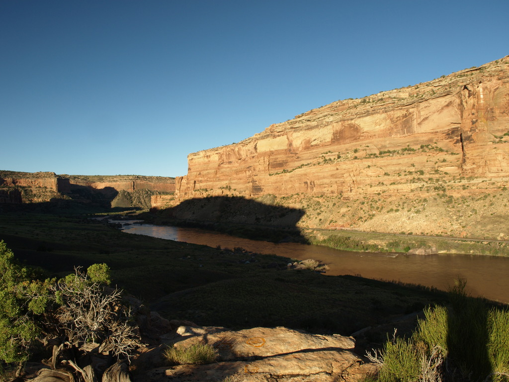
As you head down from the put-in, Ruby Canyon is the first canyon you'll enter. Watch the walls for impressive numbers of swallow nests clinging to the cliff overhangs. Ruby is relatively short, but Rattlesnake Canyon comes in on the left in this stretch. Rattlesnake Canyon has the second largest concentration of arches in the world, after Arches National Park in Utah, although it is a strenuous and long hike to reach them from the river.
Soon Ruby Canyon gives way to Horsethief Canyon. It is easy to recognize the difference, as the railroad begins paralleling the river at the start of Horsethief and follows the river for the rest of the trip.
Mee Canyon on river left at about mile 13 is a great hiking opportunity for the ambitious. Most just go a couple of miles up and back, but the canyon is long if you want to go farther.
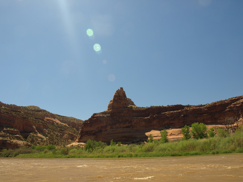
The water is flat, and easy paddling until about half way through, when you reach Black Rock at about mile 16.
Black Rocks is easy to recognize, as it is the place where the river makes an abrupt left turn and black metamorphic rock appears. This is some of the oldest rock in the area and marks the beginning of a mile-long section of turbulent water. About halfway through this mile long section, several large boulders form the obvious rapid. Staying far left will avoid it for the most part. Once past the rapid, the turbulent water quickly eases, and it's back to flat water.
Down from Black Rocks, the first side canyon on the right provides a short hike to pictographs. It is not entirely obvious, but you should pull the boat up under the railroad bridge. The hike is on the east (right side) of the canyon and has a register at the beginning. It is short and will take about 20 minutes round trip to reach the pictograph.
From there down, the canyon opens and becomes somewhat less interesting. Pay attention when the canyon opens fully, as you are nearing the Westwater takeout on river right.
Photos
Maps


12S 689430E 4338424N
39°10'28"N 108°48'26"W
12S 684776E 4337286N
39°09'55"N 108°51'40"W
12S 684665E 4337254N
39°09'54"N 108°51'45"W
12S 684395E 4337528N
39°10'03"N 108°51'56"W
12S 684310E 4337601N
39°10'05"N 108°51'60"W
12S 684072E 4337701N
39°10'09"N 108°52'09"W
12S 682346E 4339829N
39°11'19"N 108°53'19"W
12S 682074E 4339860N
39°11'20"N 108°53'31"W
12S 681966E 4339858N
39°11'20"N 108°53'35"W
12S 681888E 4339865N
39°11'20"N 108°53'38"W
12S 681743E 4339842N
39°11'20"N 108°53'44"W
12S 681625E 4339800N
39°11'19"N 108°53'49"W
12S 679912E 4340776N
39°11'51"N 108°54'60"W
12S 679927E 4340851N
39°11'54"N 108°54'59"W
12S 678599E 4340883N
39°11'56"N 108°55'54"W
12S 678503E 4340499N
39°11'44"N 108°55'59"W
12S 678442E 4339980N
39°11'27"N 108°56'02"W
12S 676533E 4337877N
39°10'20"N 108°57'23"W
12S 676456E 4337408N
39°10'05"N 108°57'27"W
12S 676550E 4337248N
39°09'60"N 108°57'23"W
12S 676601E 4337139N
39°09'56"N 108°57'21"W
12S 676665E 4337018N
39°09'52"N 108°57'18"W
12S 676731E 4336646N
39°09'40"N 108°57'16"W
12S 676823E 4336339N
39°09'30"N 108°57'13"W
12S 674494E 4335972N
39°09'20"N 108°58'50"W
12S 673450E 4335907N
39°09'18"N 108°59'33"W
12S 673241E 4335883N
39°09'18"N 108°59'42"W
12S 673207E 4335827N
39°09'16"N 108°59'44"W
12S 673152E 4335635N
39°09'10"N 108°59'46"W
12S 673108E 4335536N
39°09'07"N 108°59'48"W
12S 673048E 4335141N
39°08'54"N 108°59'51"W
12S 673005E 4335072N
39°08'52"N 108°59'53"W
12S 673036E 4335016N
39°08'50"N 108°59'51"W
12S 672970E 4334887N
39°08'46"N 108°59'54"W
12S 672983E 4334727N
39°08'40"N 108°59'54"W
12S 672923E 4334555N
39°08'35"N 108°59'57"W
12S 672767E 4334466N
39°08'32"N 109°00'03"W
12S 672452E 4334340N
39°08'28"N 109°00'16"W
12S 670933E 4334042N
39°08'20"N 109°01'20"W
12S 670787E 4334295N
39°08'28"N 109°01'26"W
12S 670928E 4333874N
39°08'14"N 109°01'20"W
12S 670846E 4333743N
39°08'10"N 109°01'24"W
12S 670992E 4333315N
39°07'56"N 109°01'18"W
12S 669131E 4331480N
39°06'58"N 109°02'37"W
12S 664242E 4328163N
39°05'14"N 109°06'04"W