 Hiking
Jones Hole
Hiking
Jones Hole
Dinosaur National Monument
Overview
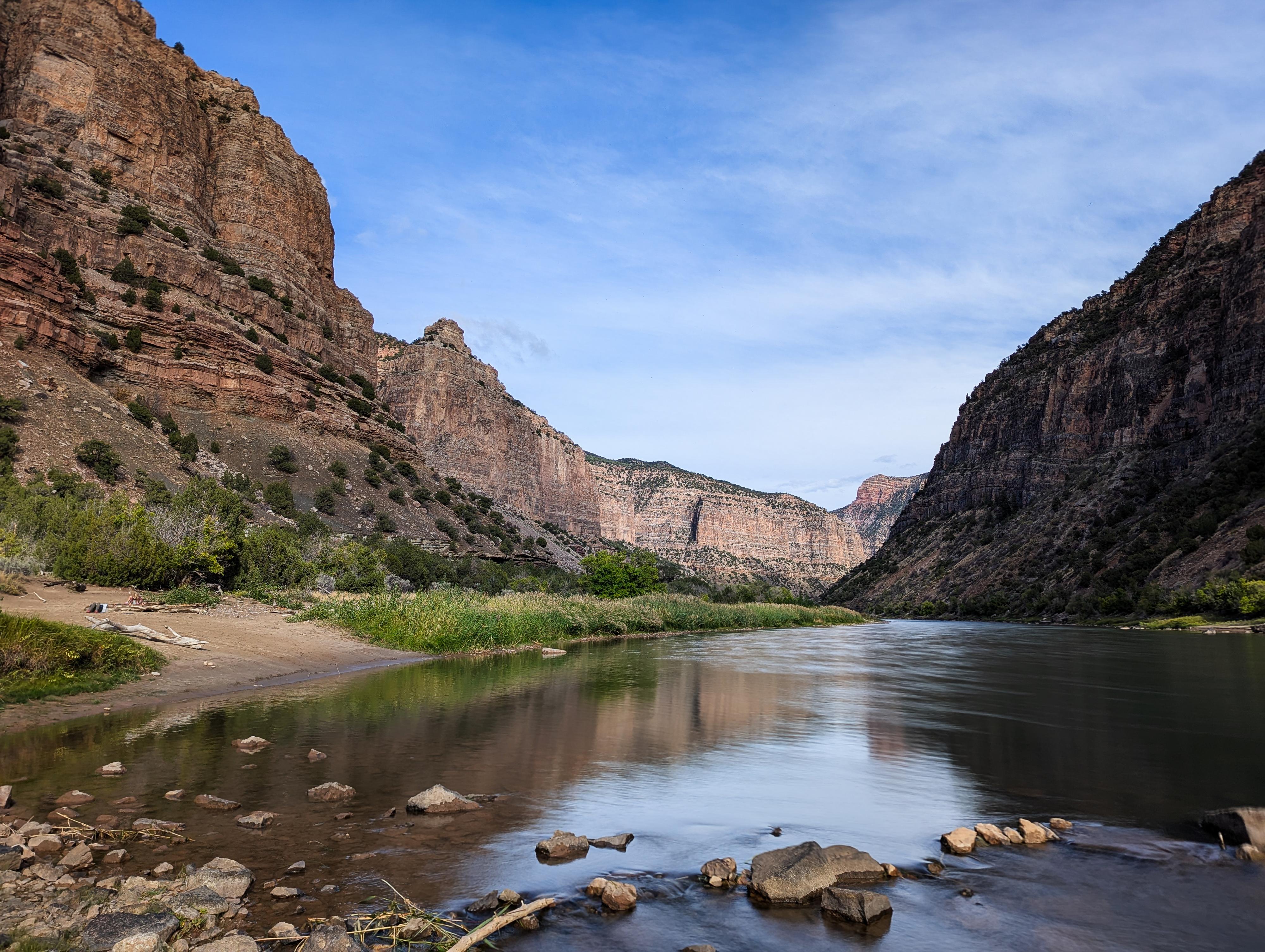
Tucked away in a quiet corner of Dinosaur National Monument, the Jones Hole Trail is one of the most scenic hikes I have done in the monument. Beginning near the Jones Hole National Fish Hatchery, this lush canyon feels like an oasis in the rugged, high-desert landscape. A crystal-clear stream runs the length of the hike, shaded by cottonwoods and flanked by sheer cliffs, creating a striking contrast of greenery against red rock and limestone cliffs. This is a hike both Diane and I had wanted to do for years, and we were even more dazzled by the hike than I expected to be.
The trail follows Jones Hole Creek for nearly four miles to its confluence with the Green River. This entire stretch is very popular with anglers. Along the way, you are very likely to see abundant wildlife, as well as prehistoric rock art panels left behind by the Fremont people nearly a thousand years ago. A short side trail leads to the small Ely Creek Falls, a refreshing cascade that tumbles into a fern-lined grotto.
You are required to have a permit to camp in Jones Hole. There is one site, about 2 miles from the trailhead, at Ely Creek that is reservable through Dinosaur National Monument year-round.
There are 4 sites at the confluence of Jones Hole and the Green River. These are only reservable by hikers during the low-use river season. Green River's high-use season is from the second Monday of May through the second Friday of September. Green River's low-use season is the remaining dates from September through May.
We backpacked the first Saturday it was available in September 2005. If you backpack in the low-use season, I cannot recommend campsite 4 at the Green River enough. All were pretty, but 4 is outstanding. If camping at the Green River, this makes a very pleasant 2-day backpack of about 5 miles a day. We, including our 8-year-old, loved it and thought the hike and camping were top-notch.
Getting There
From downtown Vernal, drive north on South Vernal Avenue for about a half-mile.
Turn right onto 500 North Street and continue for about 3 miles.
Stay straight as the road becomes Diamond Mountain Road. Follow this for about 23 miles as it climbs onto the Diamond Plateau.
Continue onto Jones Hole Road and follow it for about 12.5 miles until you reach the Jones Hole Fish Hatchery and trailhead parking area.
Expect about a 1-hour for the approximately 39 mile drive from Vernal.
Route Description
Rock art and historic sites are fragile, non-renewable cultural resources that, once damaged, can never be replaced. To ensure they are protected, please:
- Avoid Touching the Petroglyphs: Look and observe, BUT DO NOT TOUCH!
- Stay on the Trails: Stay on the most used trails when visiting sites, and don't create new trails or trample vegetation.
- Photography and Sketching is Allowed: Do not introduce any foreign substance to enhance the carved and pecked images for photographic or drawing purposes. Altering, defacing, or damaging the petroglyphs is against the law -- even if the damage is unintentional.
- Pets: Keep pets on a leash and clean up after them.
- Artifacts: If you happen to come across sherds (broken pottery) or lithics (flakes of stone tools), leave them where you see them. Once they are moved or removed, a piece of the past is forever lost.
To The Bridge (1.7-ish miles by my device)
From the Fish Hatchery, follow the signs as the trail goes along the edge of the fenced hatchery. There will be almost constant short side trails along the hike that go to the river for anglers, but the main trail seemed obvious throughout. The first portion of the hike is flanked by towering sandstone cliffs to the west and limestone to the east.
The trail meanders down on the east side of the creek until about mile 1.7 where it crosses the creek via a wood bridge.
Deluge Shelter
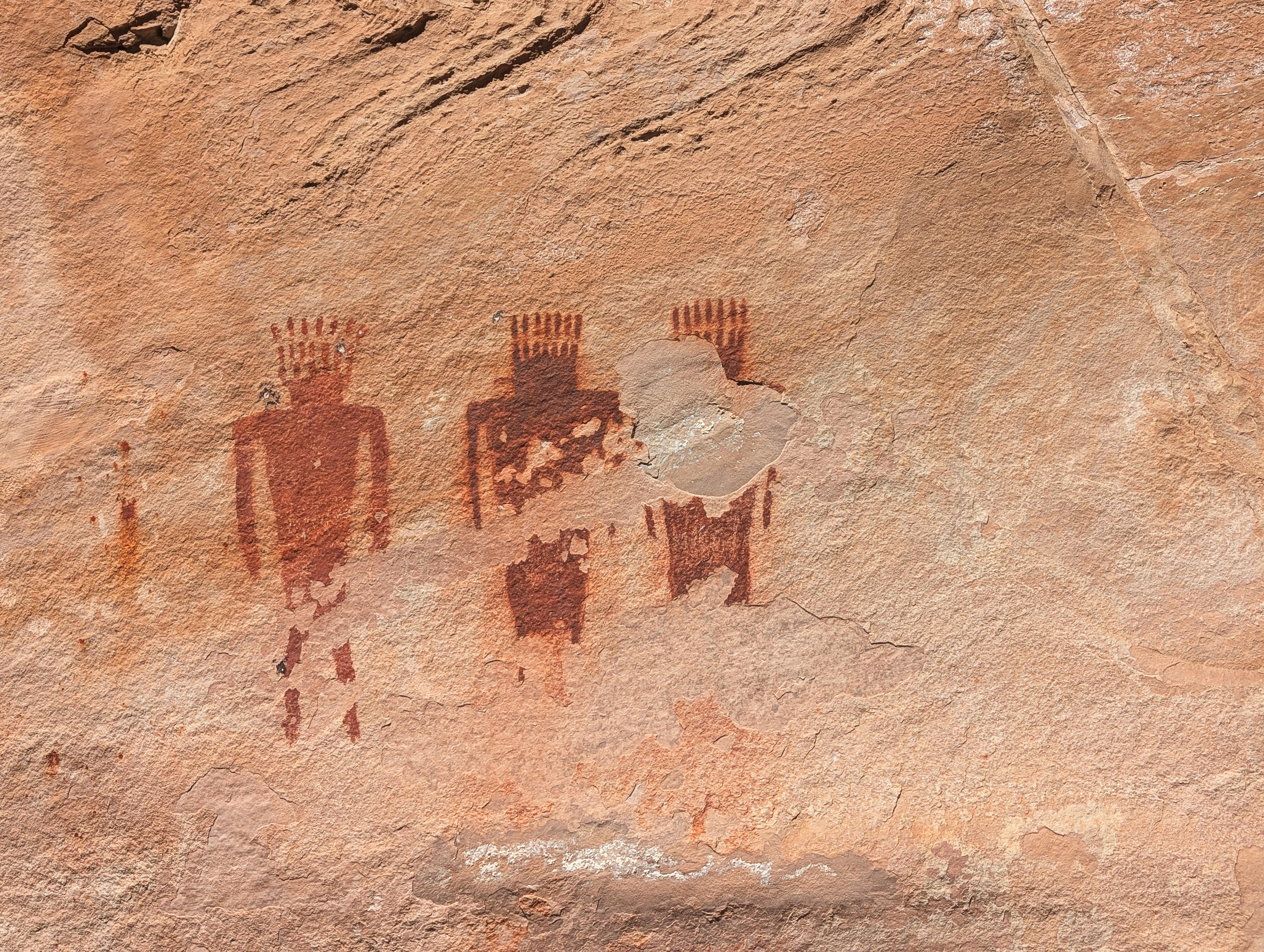
Just past the bridge crossing, on our visit, there was a trail on the right almost immediately. Skip this one, and take the next side trail on the right a short distance to a faded petroglyph panel, then return to the main trail.
Continuing down the main trail, look for another side trail on the right, complete with rock steps. Take this side trail up to the cliff and follow it down along the cliff to see many stunning pictographs and a couple of petroglyphs. This area is known as the Deluge Shelter, with the biggest overhang being at the end before the side trail descends rock steps again to rejoin the main trail. There is an informational sign along this trail as well.
From the informational sign:
Sheltering Ancient Images
Between 700 and 1700 years ago this area was home to various groups of indigenous peoples. The variety of petroglyphs they left behind are direct evidence of their attempt to integrate art into their lives. They were not just carving in this cliff face for fun or hobby. How do we know? People who are struggling would not be able to devote the time or energy required to create so many intricate designs. Artistic expression is typically found in cultures and societies where people are living comfortably, are safe, and have their basic physical and emotional needs met.
Why these specific designs? The images along this cliff face may have been related to hunting, clan identification, territorial marking, ceremonial or religious purposes, or way finding, record keeping, or purely for leisure and enjoyment. For further insight and understanding, we can listen to modern native voices. Many of these images live on in the lives and cultures of the Ute and other indigenous peoples connected with this land.
For centuries, this rock overhang has shaded pictographs from the strong sun, wind and rain. This dark and limited exposure to the elements has helped to preserve the vibrant colors in these ancient images.
Not too far from the rock art, at about 2 miles from the trailhead according to my device, is the junction with Ely Creek.
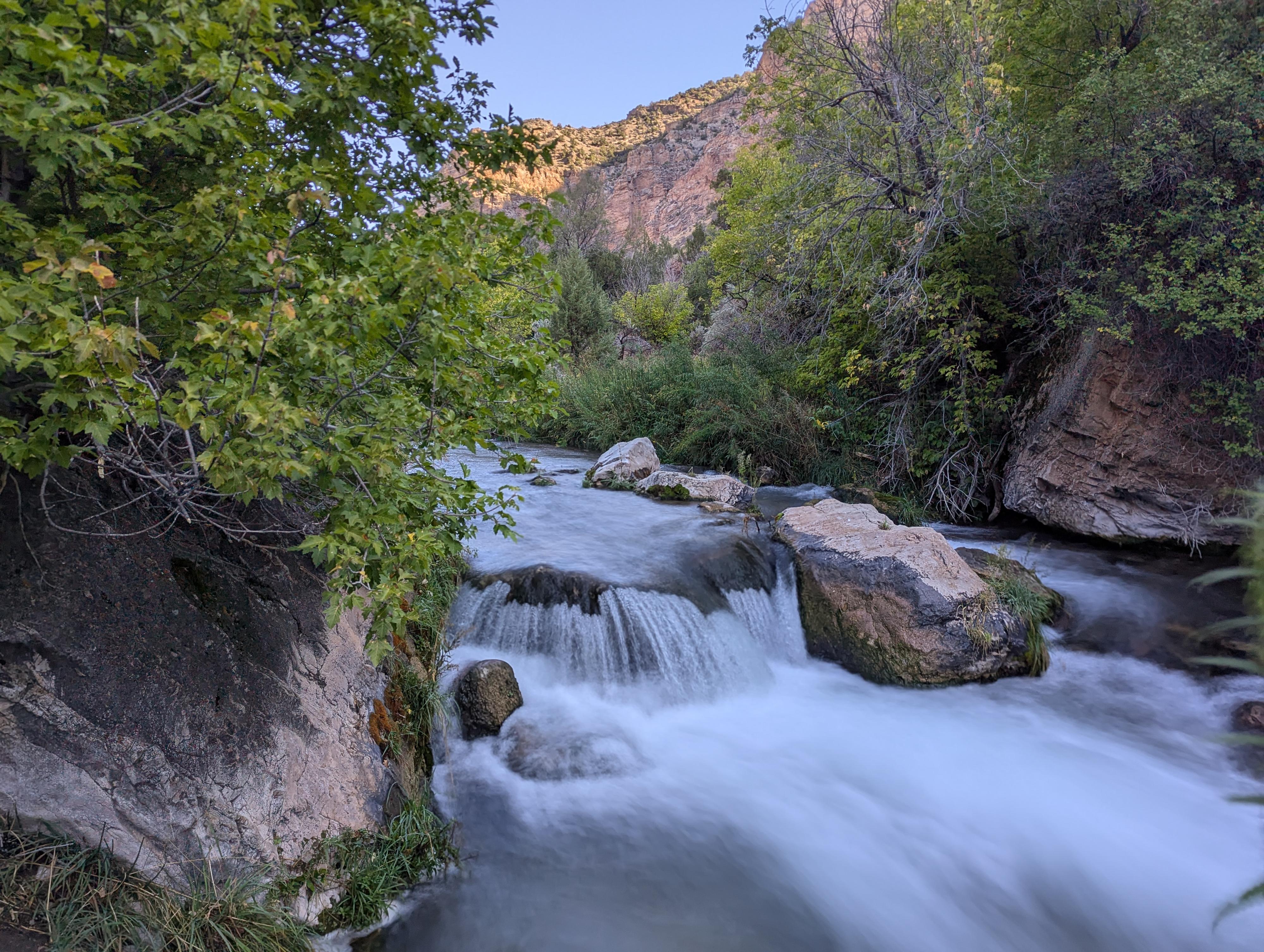
Ely Creek Falls Side Trip (less than 1/2 mile round trip)
Ely Creek Falls is a short distance up the side trail. Maybe about 1/4 of a mile and less than 10 minutes. It is worth the short side trip to see the 4 m falls. The Ely Creek trail continues up past the falls. I only had time to continue another 5 or 10 minutes, but it is shaded and quite pretty.
Just a couple of minutes down from the Ely Creek junction is the Ely Creek campsite. As of 2025, it has a bear box and pit toilet up on the hill behind it.
To The Green River (1.8-ish miles, a bit over 2 miles to campsite 4)
Continuing down from Ely Creek, the trail changes a bit. Both walls are now towering limestone, and the trail begins crossing more open and sunny areas. When you are just about to the confluence with the Green River, the trail begins to split into a bunch of use trail.
Campsite 1 is on the east side of the creek and requires crossing it. For campsites 2-4, follow the social trails to the shore, then walk along the banks of the Green River. Sites are marked by a large wooden post. It is about 0.4 miles to campsite 4, the farthest one east along the river.
Keep an eye out for animals. We had a beaver spend the evening along the shore near our campsite on our visit. It was a treat! In the morning there were 7 bighorn sheep near the creek as we headed out, as well as countless birds. It is an oasis for people and animals alike.
Return the same way.
Photos
Videos
Backpacking Jones Hole - Dinosaur National Monument
Maps

12T 664429E 4494764N
40°35'14"N 109°03'25"W
12T 664551E 4492803N
40°34'11"N 109°03'22"W
12T 664543E 4492751N
40°34'09"N 109°03'22"W
12T 664524E 4492681N
40°34'07"N 109°03'23"W
12T 664493E 4492629N
40°34'05"N 109°03'24"W
12T 664506E 4492600N
40°34'04"N 109°03'24"W
12T 664472E 4492341N
40°33'56"N 109°03'26"W
12T 664257E 4492230N
40°33'52"N 109°03'35"W
12T 664471E 4492309N
40°33'55"N 109°03'26"W
12T 664466E 4492280N
40°33'54"N 109°03'26"W
12T 664367E 4489615N
40°32'28"N 109°03'33"W
12T 664219E 4489546N
40°32'25"N 109°03'39"W
12T 664129E 4489513N
40°32'24"N 109°03'43"W
12T 664008E 4489518N
40°32'25"N 109°03'48"W
12T 663741E 4489546N
40°32'26"N 109°03'59"W