 Hiking
Coyote Gulch
Hiking
Coyote Gulch
Hole In The Rock
Overview
Packable human waste bags (WAG Bags) are required in Coyote Gulch.
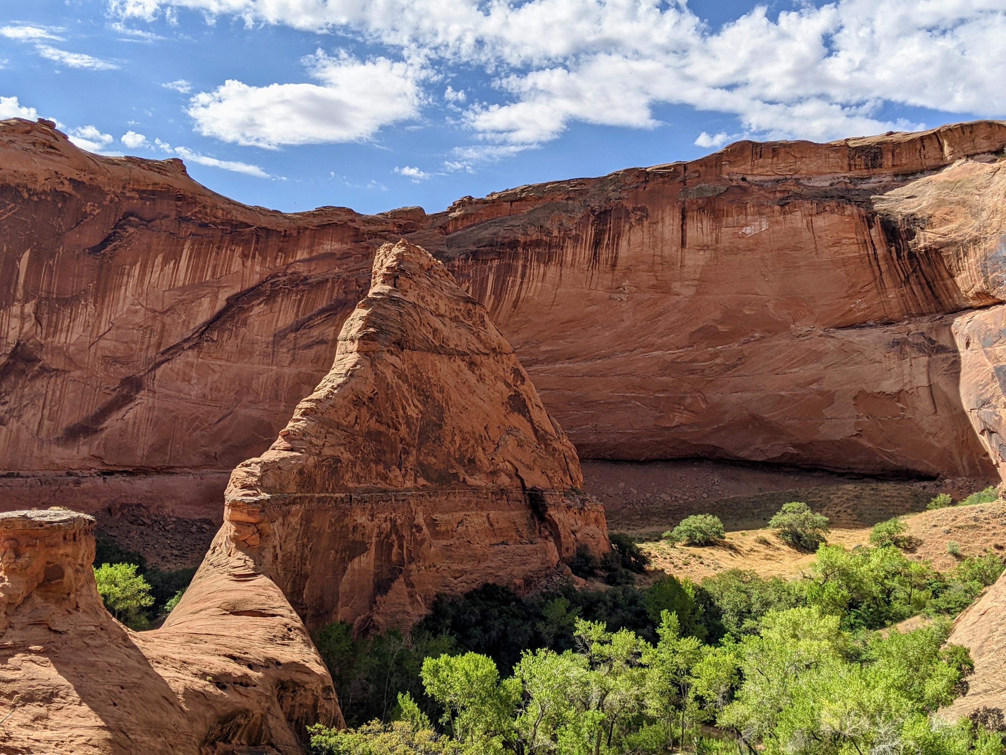
Coyote Gulch is one of, if not thee, premier canyon in Grand Staircase Escalante National Monument. The canyon, emblematic of the beauty of the Escalante region, is often near the top of desert hikers and backpackers bucket lists. This is a canyon that has astounding beauty and charm, with seemingly each bend of the canyon revealing a scene to marvel at. Arches, waterfalls, cavernous alcoves, rock art, and a plethora of color make this an amazing journey.
Because of its iconic status, the canyon sees many visitors and is not necessarily the best place to visit if looking for solitude or an adventure off the beaten path.
There are many ways to do Coyote Gulch. I’ll discuss what I think are the two best options here:
Backpacking
Backpacking is the way to see all of Coyote Gulch and get a more deep sense of the canyon. If backpacking, many come in from Hurricane Wash, Red Well, or Chimney Rock trailhead and out Crack in the Wall trailhead. Most will want 1-2 nights (2-3 days) for the trip. These options require a car shuttle. Since I rarely have a car shuttle, the description below goes from Crack In The Wall Trailhead, cross-country to Hurricane Wash, then down Coyote Gulch and out Crack In The Wall. This route is about 20 miles and sees all of Coyote Gulch with no backtracking, and moderate route finding.
Day Hike
More and more, visitors are visiting Coyote Gulch via the steep access ridge just east of Jacob Hamblin Arch. This is a quick way into Coyote Gulch, about 2 miles from the trailhead to the bottom of the gulch. Though a short access route, it should be emphasized that the ridge descent is very steep. MOST WILL WANT A ROPE. If doing this “shortcut” route in, be sure to bring a 50 m ( 165 ft. ) rope and have the skills to safely descend/ascend the rope. Also, keep in mind going up or down is more challenging with a heavy pack. Often you will find a rope in place. The NPS does not maintain these, be sure to inspect carefully before deciding to trust them. The anchor at the top is a small arch/solution pocket that should be rigged with care to avoid any unnecessary rubbing.
Some do the day hike via the shortcut route into the canyon, then exiting Crack In The Wall (or vice-versa). This is an excellent, though strenuous, loop.
A few more notes I think are important to keep in mind regardless if how you visit:
- Coyote Gulch can be visited in the spring, summer, or fall. It sees more visitors in the summer than I would have expected. On a 95 degree summer trip, I saw a few dozen people in the canyon. If visiting in hot times of the year, be sure to have plenty of water for the approach and exit and plan them for cooler times of the day. The route out Crack In The Wall is strenuous and brutal on a hot day. Spring brings more crowds, while fall has amazing colors.
- The Crack In The Wall exit is exactly that, a crack in the cliff wall. It is quite narrow. If you have a large pack, bring a 15 m ( 50 ft. ) rope that can be used to hoist the pack up (outside of the crack) after ascending it. I had to turn sideways to fit up the crack. With a 42-inch chest, it was not a tight fight. If, however, you are a larger hiker/backpacker, the crack may be a squeeze. Probably not fun if you are claustrophobic.
- Bring a trash bag and pickup and trash you find in the canyon. There was a disappointingly large amount on my trip that I packed out.
- Be sure to have a good filter.
- Before heading out, check with the National Park Service for current regulations. They are available on their Coyote Gulch page. As of 2022, backpacking in Coyote Gulch requires a free backpacking permit that is available at the trailhead. Given the popularity of the area, rules and regulations are likely to change.

Getting There
Head east out of the town of Escalante about 5 miles on highway 12 until the well signed Hole in the Rock road on the south side of highway 12. Reset the odometer as you turn onto this road.
Route Description
Rock art and historic sites are fragile, non-renewable cultural resources that, once damaged, can never be replaced. To ensure they are protected, please:
- Avoid Touching the Petroglyphs: Look and observe, BUT DO NOT TOUCH!
- Stay on the Trails: Stay on the most used trails when visiting sites, and don't create new trails or trample vegetation.
- Photography and Sketching is Allowed: Do not introduce any foreign substance to enhance the carved and pecked images for photographic or drawing purposes. Altering, defacing, or damaging the petroglyphs is against the law -- even if the damage is unintentional.
- Pets: Keep pets on a leash and clean up after them.
- Artifacts: If you happen to come across sherds (broken pottery) or lithics (flakes of stone tools), leave them where you see them. Once they are moved or removed, a piece of the past is forever lost.
Day Hike
From the Water Tank trailhead, look north. The cairned trail goes to the left, west, of the large dome visible from the trailhead. The trail is well used, well cairned, and easy to follow. After passing the dome, the trail crosses the sandy plain for just a few minutes before reaching slickrock. Keep a sharp eye, the cairns are easy to find and follow, but could be missed if being unattentive. The cairns take you to the steep ridge that descends into Coyote Gulch. I recommend a rope for descent.
Upstream From the Jacob Hamblin Entrance
Once in the bottom of Coyote Gulch, going upstream reaches Jacob Hamblin Arch in just a few minutes at the next bend. It is about 1.7 miles one way from where you entered Coyote Gulch to Hurricane Wash upstream. This section is lovely, with deep overhangs and high navajo walls. I high recommend going as far as the confluence Hurricane Wash if possible. It is easily recognizable as the first side canyon coming in on the left.
Downstream From the Jacob Hamblin Entrance
From the bottom of the Jacob Hamblin Entrance, it is about 1.7 miles one way downstream to Coyote Natural Bridge. This section is lovely, though a bit more open than the area above Jacob Hamblin Arch. See the backpacking section below for specifics on this section.
--
Backpacking From the Crack In The Wall Trailhead
From Crack In The Wall Trailhead to Hurricane Wash (6.1 miles)
From the trailhead, start on the trail that heads towards Crack In The Wall, then almost immediately west on an old two-track road. This can be hard to spot, and if it has been windy recently, you may not see other footprints. Follow the two-track to its end in about 0.5 miles at the first patch of slickrock breaking up the sandy plain. Route finding is tricky from here, keep an eye on the map.
Continue west and a touch north, staying at about the same elevation. In just a few minutes you will reach slickrock and easier hiking. Once on slickrock, continue west, staying far enough from the rim of the slickrock that the path is easy, but not getting too far north. Views to the north of Coyote Gulch and the slickrock expanse north of it are excellent.
It is about 2.5 miles (60-75 minutes) from the Crack In The Wall trailhead to where you will intersect the Jacob Hamblin Arch shortcut route. Watch closely for cairns as you are heading west. The cairned shortcut trail was easy to find on my visit, but you have to be looking for cairns. Once you find the cairns, head south, following the shortcut trail until on the west side of the large dome.
From the west side of the large dome, Chimney Rock is visible to the west. Head straight to it, or just a little south of it. The route dips down into a shallow valley before climbing back up. Persist in heading west, the terrain becomes more slickrock with towers and small canyons. If you intersect a canyon, paralleling the route, stay to the north of it. The big dome to Hurricane Wash is about 2.7 miles. You should intersect Hurricane Wash right about where the side canyon mentioned above enters. Several easy routes lead to the bottom of Hurricane Wash.
Hurricane Wash to Coyote Gulch (2.7 miles)
During the drought of 2022, I didn’t find water in Hurricane Wash until about 1.6 miles down from where this route entered. There are good camping spots in the lower section. It is about 2.7 miles from where the route entered Hurricane Wash to Coyote Gulch.
Coyote Gulch (8 miles)
Heading down Coyote Gulch, the Navajo Sandstone walls rise and the iconic deep overhangs and curvaceous bends begin. Keep an eye on both sides of the canyon for Moki steps carved up the ridges by native peoples for entries/exits. There are said to be many. I marked one on the map below. They can be hard to spot unless you have a good eye.
It is about 1.7 miles from Hurricane Wash to Jacob Hamblin Arch. This section has the biggest overhangs of Coyote Gulch. Jacob Hamblin Arch is impressive, as is the bend in the stream that goes around it. The ridge on the south (right) side of Coyote Gulch just down stream from Jacob Hamblin Arch is the shortcut route that people climb in/out of. You are likely to encounter more people in this section here than the rest of the hike. There is good camping throughout Coyote, but I would recommend not camping very close to this entrance/exit as it tends to be busy and noisy at times.
From the bottom of the Jacob Hamblin Entrance, it is about 1.7 miles one way downstream to Coyote Natural Bridge. The canyon opens a bit here. Coyote Natural Bridge, at over 60 feet high, is quite the opening to pass through.
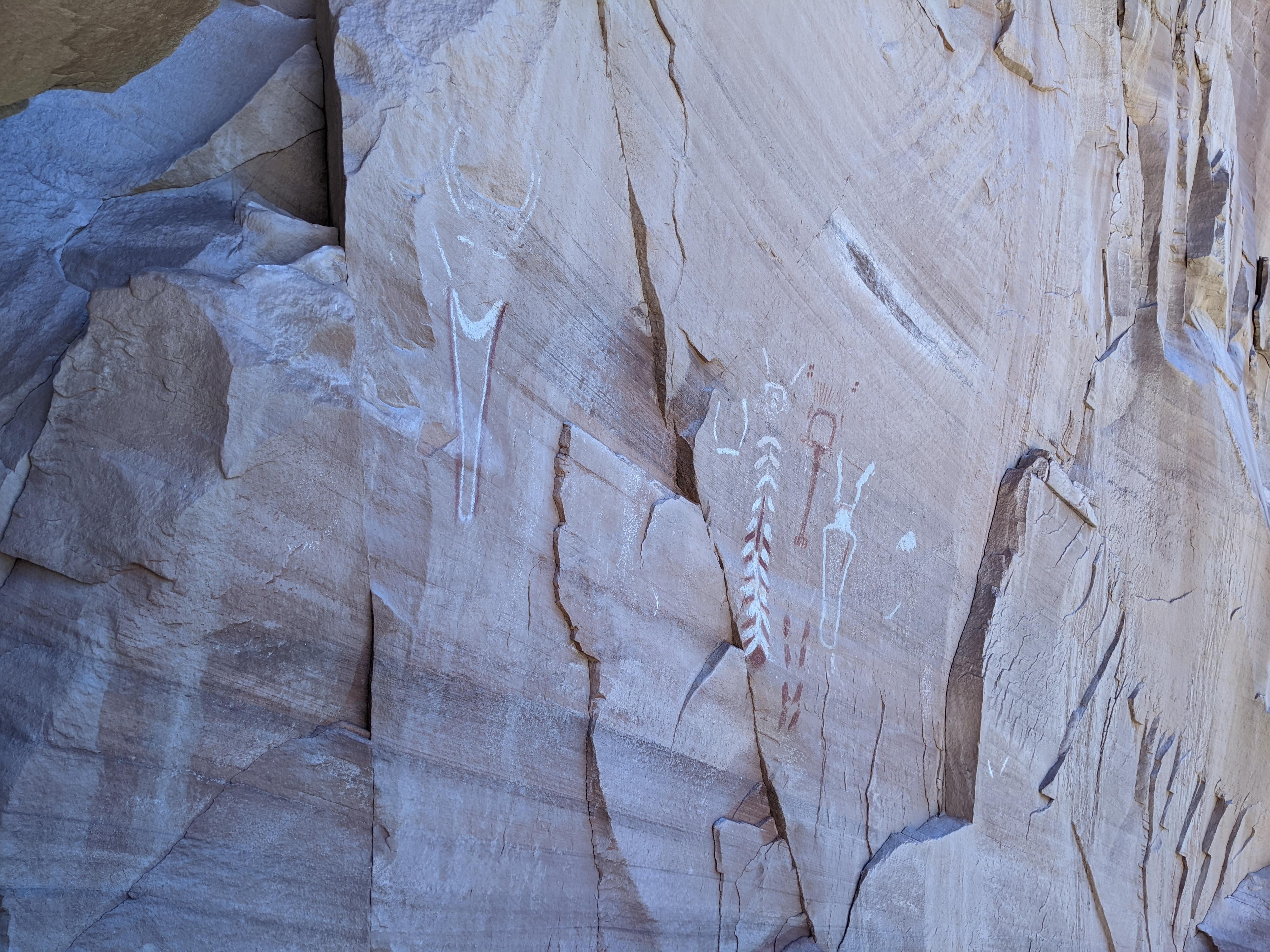
About 3/4 of a mile below Coyote Natural Bridge, right after a bend where you head north, is a large sand hill with a social trail heading up it. The top of the sand hill is an alcove of archeological finds and a pictograph panel.
From the panel alcove, the canyon continues to widen and change character as it transitions into the Kayenta sandstone layer. Small idyllic waterfalls become commonplace and the walls take on deep, rich colors.
About 1.7 miles down from the alcove panel, just past a small waterfall, Cliff Arch is on the left. It, originally, was known as Jug Handle Arch. A half mile beyond Cliff Arch is a waterfall that is passed on the right. There is a short trail on the left of these falls that goes to a spring that drips from above. If wanting to purify cleaner water than the stream, this is an excellent place to fill up.
The final 1.5 miles to the exit is full of cascades, waterfalls and vibrant colors. When the streambed becomes choked with large boulders, and there is a steep sand bank on the right with a trail, you have reached the exit.
Exit (2.7 miles)
Fill up on water before the exit, there won’t be any more sources available. If it is a hot day, consider waiting until the day cools. Or, do like I did, and lay in the stream to make sure everything is fully soaked before starting the big climb up in the sun.
The trail climbs steeply up the sand bank. The first part is the steepest, and once up a level, the cliff band that holds the Crack In The Wall is visible. To the northeast, the impressive Stevens Arch is also visible above the river. Large enough that stunt pilots are said to have flow through it.
From the river to the exit is a gain of about 700 vertical feet in soft sand. Social trails leave the main trail a time or two, but follow the most used trail up. From below, Crack In The Wall just looks like a low spot on the cliff band with a trail heading up to it.
Once the trail reaches the cliff band, the Crack In The Wall is clear. It is truly a crack. Squeeze up through the first section, with a small boulder to overcome near the top. The crack opens for a moment, then narrows again for the second section, that is wider and easier than the first. Pop out on top, triumphant! Rope groves below where you top out show the path people hoist packs up by.
From the top, follow cairns as they head southwest across the slickrock. Soon you will see the Crack In The Wall trailhead on top of the hill. Head toward it, either by trending west then south to stay on slickrock as much as possible, or taking the more direct path that follows an old sandy track.
Photos
Videos
Coyote Gulch - Hole In The Rock
Maps


12S 495688E 4138416N
37°23'33"N 111°02'55"W
12S 499201E 4139652N
37°24'13"N 111°00'32"W
12S 497925E 4140284N
37°24'34"N 111°01'24"W
12S 496128E 4140730N
37°24'48"N 111°02'38"W
12S 495795E 4139435N
37°24'06"N 111°02'51"W
12S 492383E 4139807N
37°24'18"N 111°05'10"W
12S 493489E 4141155N
37°25'02"N 111°04'25"W
12S 493517E 4141208N
37°25'04"N 111°04'24"W
12S 494845E 4141540N
37°25'14"N 111°03'30"W
12S 496001E 4141413N
37°25'10"N 111°02'43"W
12S 496166E 4141358N
37°25'08"N 111°02'36"W
12S 496303E 4141462N
37°25'12"N 111°02'30"W
12S 497507E 4141121N
37°25'01"N 111°01'41"W
12S 497529E 4141069N
37°24'59"N 111°01'41"W
12S 498078E 4140995N
37°24'57"N 111°01'18"W
12S 499345E 4141442N
37°25'11"N 111°00'27"W
12S 499739E 4141617N
37°25'17"N 111°00'11"W
12S 501093E 4142391N
37°25'42"N 110°59'16"W
12S 501268E 4141386N
37°25'09"N 110°59'08"W
12S 500505E 4140653N
37°24'46"N 110°59'39"W