
 Ash Springs Rock Art Site
Ash Springs
Overview
The small ranching community of Ash Springs sits along US-93 in southern Nevada. The area is very sparsely populated, and typical of rural Nevada. Wide open space, distant mountains, and few people. Though Ash Springs is likely best known for its natural hot springs, the Ash Springs rock art site, sitting just off US-93, is a stop all rock art lovers should make if in the area.
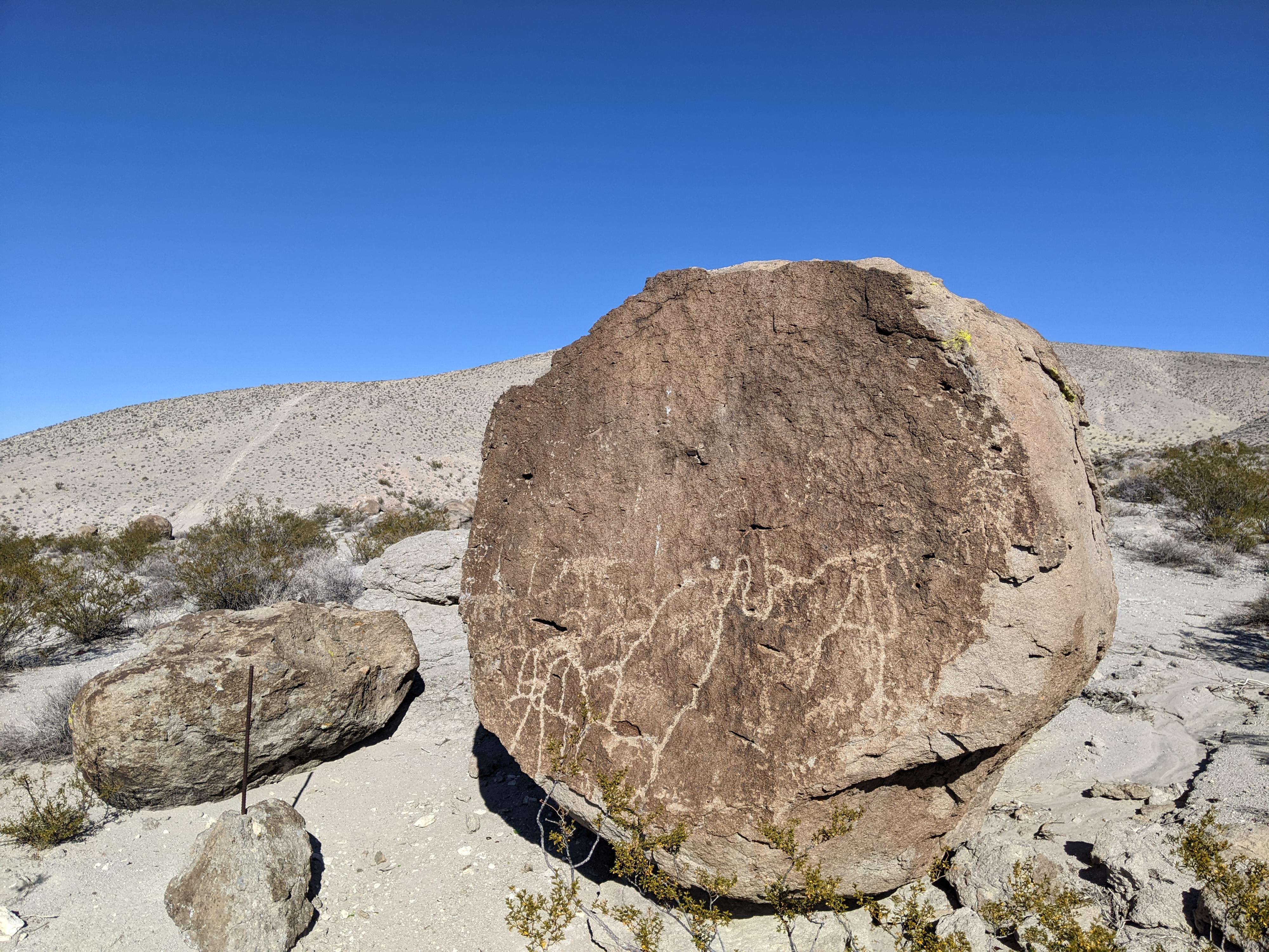
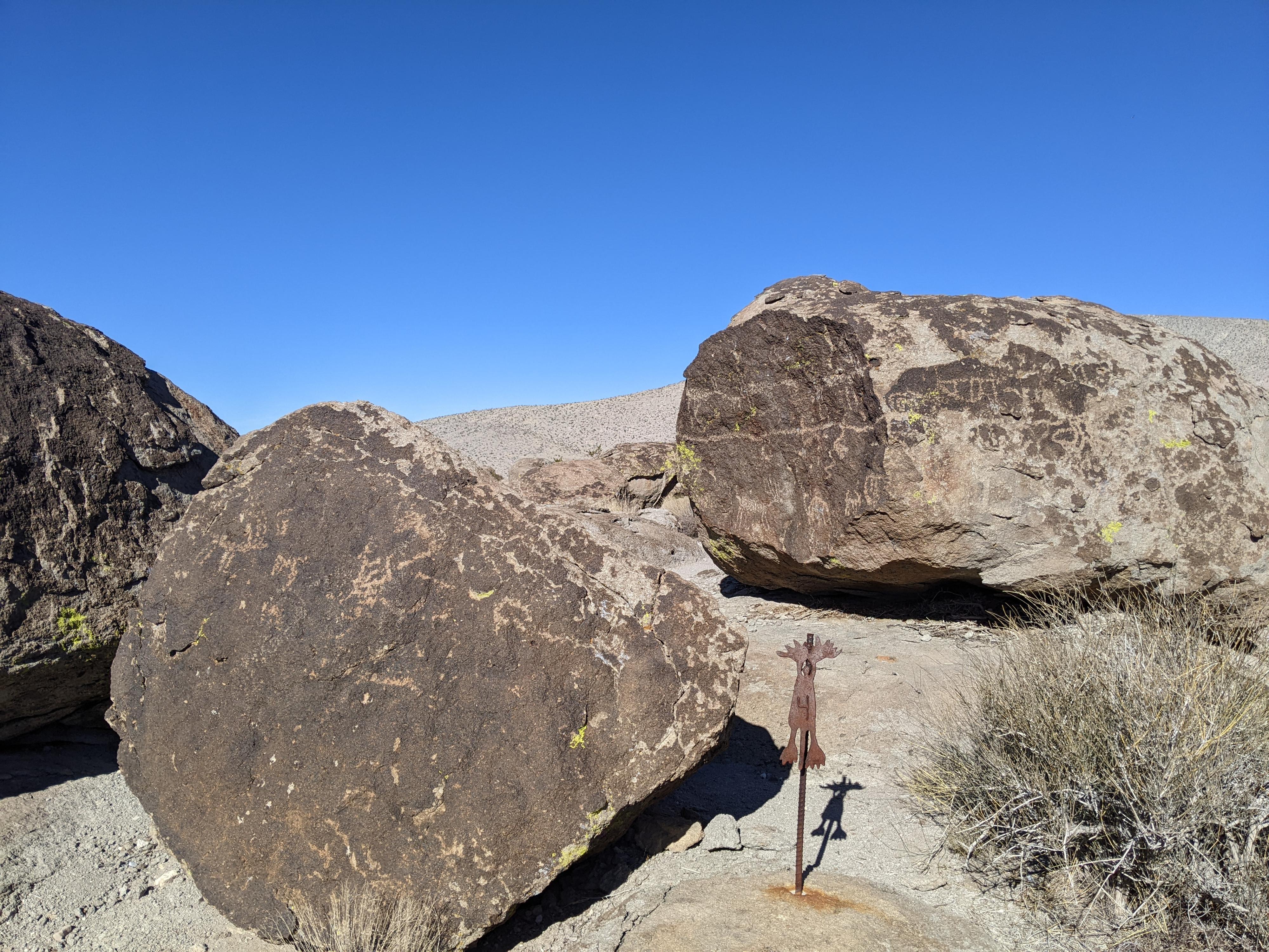
The site sits on a hill, overlooking the valley below. The BLM has created a short trail meandering through the boulders to visit the many panels. There are 18 markers to be found in the jumble of boulders. On our visit, the trail was indefinite in quite a few places. Expect to spend a bit of time searching out the markers. It is worth the effort, however, as the area has quite a large collection of rock art. We found all but number 17 which was either missing or we simply missed it.
Getting There
Surprisingly, the route to the site is not labeled. The easiest way to find it is to go south on US-93 from the junction of US-93 and NV-318 for 5.1 miles toward Alamo. A dirt road on the left (east) side of US-93t climbs a hill. This is just south of the community of Ash Springs.
Follow the dirt road as it climbs the hill heading south. It curves east a bit and reaches a junction with a gate about 1000’ from US-93. Go left here, through the gate. On our visit, the gate was in tatters, but still somewhat easy to open/close. Once through the gate, continue on another 700’ to a parking area on the left that is the trailhead. The road is dirt, but should be passable by most vehicles in most conditions. Easily walked if needed.
Route Description
Rock art and historic sites are fragile, non-renewable cultural resources that, once damaged, can never be replaced. To ensure they are protected, please:
- Avoid Touching the Petroglyphs: Look and observe, BUT DO NOT TOUCH!
- Stay on the Trails: Stay on the most used trails when visiting sites, and don't create new trails or trample vegetation.
- Photography and Sketching is Allowed: Do not introduce any foreign substance to enhance the carved and pecked images for photographic or drawing purposes. Altering, defacing, or damaging the petroglyphs is against the law -- even if the damage is unintentional.
- Pets: Keep pets on a leash and clean up after them.
- Artifacts: If you happen to come across sherds (broken pottery) or lithics (flakes of stone tools), leave them where you see them. Once they are moved or removed, a piece of the past is forever lost.
From the trailhead, follow the path. Small pieces of rebar with a number on top mark the different panels as the path meanders through the boulders. It is not long before you will reach the petroglyph that inspired the signs! The route meanders through and loops back to the trailhead.
Maps

11S 659974E 4147246N
37°27'30"N 115°11'28"W
11S 660125E 4147170N
37°27'27"N 115°11'22"W
11S 660136E 4147180N
37°27'28"N 115°11'22"W
11S 660154E 4147186N
37°27'28"N 115°11'21"W
11S 660151E 4147205N
37°27'28"N 115°11'21"W
11S 660157E 4147212N
37°27'29"N 115°11'21"W
11S 660160E 4147223N
37°27'29"N 115°11'21"W
11S 660155E 4147231N
37°27'29"N 115°11'21"W
11S 660157E 4147247N
37°27'30"N 115°11'21"W
11S 660136E 4147260N
37°27'30"N 115°11'22"W
11S 660094E 4147254N
37°27'30"N 115°11'23"W
11S 660039E 4147250N
37°27'30"N 115°11'26"W
11S 660028E 4147256N
37°27'30"N 115°11'26"W
11S 660063E 4147210N
37°27'29"N 115°11'25"W
11S 660063E 4147206N
37°27'28"N 115°11'25"W
11S 660071E 4147197N
37°27'28"N 115°11'24"W
11S 660057E 4147203N
37°27'28"N 115°11'25"W
11S 660045E 4147183N
37°27'28"N 115°11'26"W