Roadside Attraction Devil’s Throat
Gold Butte National Monument
Overview
Sat 107 | 80 |
Sun 110 | 81 |
Mon 109 | 81 |
Tue 105 | 81 |
Wed 103 | 80 |
View Full Weather Details |
Sat 107 | 80 |
Sun 110 | 81 |
Mon 109 | 81 |
Tue 105 | 81 |
Wed 103 | 80 |
View Full Weather Details |
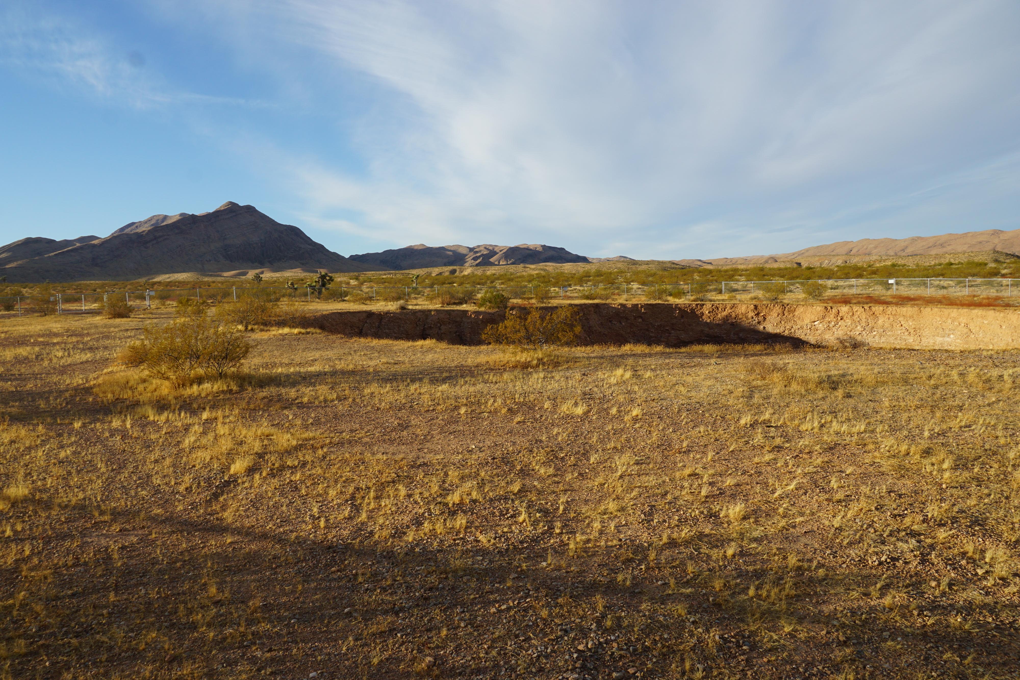
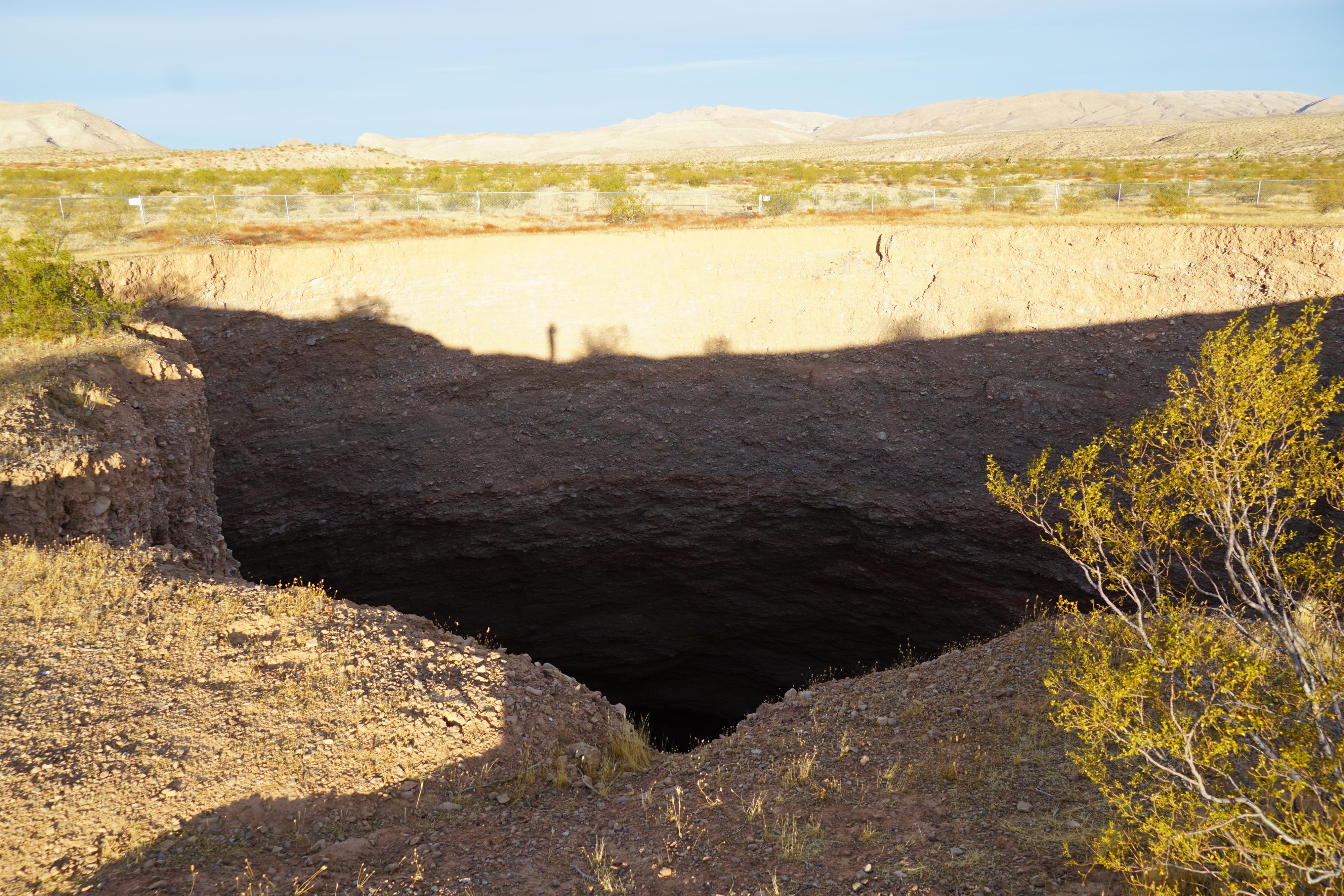
The Devil’s Throat is a great example of geology in action. In the early 1900’s, during the Gold Butte mining boom, cowboys and miners in the area suddenly saw a large cloud of dust off in the distance. Upon investigation, they found a large sinkhole where once had been open desert! The sinkhole, known as the Devil’s Throat, has grown over the years, and is currently between 110-120' across and quite deep. It is immense!
The sinkhole is impressive, but hard to get the scale of when visiting. A safety fence has been put up around the permitter. You can see several old fences near the sinkhole. As the sinkhole has grown, new fences have been built further back. With the last fence, they moved it quite a way back from the edge. This makes seeing into the sinkhole difficult. The edge and area around the sinkhole are unstable, getting very close is definitely not recommended!
I would rate this worth the stop if you are passing nearby, but not worth making a special trip to see.
Getting There
Reaching Gold Butte starts by taking exit 112 off Interstate 15. This is about 70 miles east of Las Vegas, or 10 miles west of Mesquite Nevada. From exit 112, head south for 3.1 miles on NV-170 toward Riverside. Just after the road crosses the Virgin River, turn right onto Gold Butte Road.
- Reset your odometer as you turn west onto Gold Butte Road. This is an old paved road that is a bit rough and gravel in sections, but passable by all vehicles in most conditions. ( 11S 748409E 4068726N / 36°43'54"N 114°13'05"W )
- 19.9 miles - Side road on the right to a couple of good primitive camping spots. ( 11S 754383E 4046395N / 36°31'45"N 114°09'32"W )
- 21.1 miles - Whitney Pocket. Good camping on the right. ( 11S 756034E 4045904N / 36°31'27"N 114°08'26"W )
- 21.15 miles - Major junction. Large parking/camping area on the right. A good road goes left (east) along the base of Whitney Pocket. This is the Whitney Pass Rd. Stay straight and reset your odometer. ( 11S 756076E 4045807N / 36°31'24"N 114°08'24"W )
- From Whitney Pocket - 3.9 miles - North Mud Wash Side Road to Little Finland, Seven Keyholes, etc... If going to Devils Throat, stay left on the main road. There is another side road at Devils Throat that also goes to Little Finland/Seven Keyholes/etc.. (Mud Wash Side Road) ( 11S 754067E 4040421N / 36°28'32"N 114°09'51"W )
- From Whitney Pocket - 7.2 miles - Junction. Right to Devils Throat on the Mud Wash Side Road. ( 11S 756032E 4035725N / 36°25'57"N 114°08'38"W )
- Mud Wash Side Road - 0.3 miles - Straight goes to Devils Throat in 0.2 miles. Right goes toward Little Finland/Seven Keyholes areas. ( 11S 755733E 4035339N / 36°25'45"N 114°08'50"W )
Route
The sinkhole is next to the trailhead. A BLM sign at the site discusses the history as well as geology that has caused the sinkhole.
From Whitney Pocket - 7.2 miles - Junction. Right to Devils Throat. |
11S 756032E 4035725N 36°25'57"N 114°08'38"W |
Mud Wash Side Road - 0.3 miles - Straight goes to Devils Throat in 0.2 miles. |
11S 755733E 4035339N 36°25'45"N 114°08'50"W |
Devil's Throat |
11S 755570E 4035122N 36°25'38"N 114°08'57"W |