 Canyoneering
Smiling Cricket Canyon (Poe Canyon)
Canyoneering
Smiling Cricket Canyon (Poe Canyon)
Waterpocket Fold
Overview
Smiling Cricket Canyon, also known as Poe Canyon and even L Canyon, was first descended by Mike Bogart and Jenny Hall in 1981 (and called Poe). Their bold descent went unrepeated and more or less unknown for almost 30 years. In 2007, Jason Pease wandered the area looking for canyons and re-found Poe, naming it Smiling Cricket. He descended it in the summer of 2008 with Mark Fleck. Of the three canyons in the area (Happy Dog, Laughing Baboon, and Smiling Cricket), Jason and Mark ended up in the biggest of the three. He and Mark took two days to descend Smiling Cricket, and his trip report ignited interest in the area. Having done canyons with Jason, I always appreciate his moxie and bold style, with Smiling Cricket being no exception.
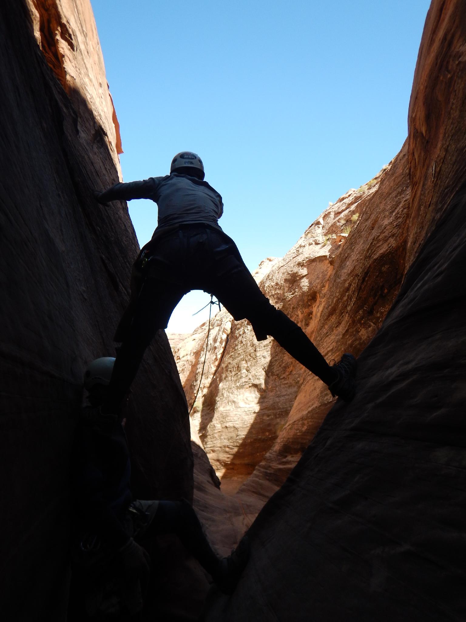
The canyon offers competent groups a chance to work through pothole problems. The problems start easy enough but build to a crescendo at the Pit of Despair. The Pit of Despair is a daunting pothole that requires almost a 50' potshot toss from a very awkward stemming stance. En route, you will be faced with confusing route finding to reach the canyon, difficult anchors, pothole escapes, and a lot of work.
OK, enough with the disclaimer. What's it like? I had heard many a tales of "Hardest canyon on the Colorado Plateau" and "I've done hundreds of canyons and never seen anything so hard!" Steve Ramras, after his descent, recounted the descent in such vivid detail it scared me off! Finally in 2015, I got a group together to do Smiling Cricket. Mark and Tyler Fallentine, Diane Menuz, Della Fixsen, and Taylor Arave. Taylor had done the canyon before, which helped ease some of the problem solving.
We found Smiling Cricket mostly a bit less than half full of water. Full, it would be at its easiest (more or less); in any other condition there will be challenges in different spots. I was surprised at the experience. Most of the potholes are straightforward potshot tosses though the volume of problems require you move quickly if you want to finish in a day. Anchors are mostly either old bolts or you will need to use sandtraps and water anchors. On our trip, we had a water anchor, which helped avoid a couple of old bolts and worked well in a couple of instances. See Taylor's facebook page to check if he is currently selling them ( Atwood Outdoor Gear ).
In short, it is hard and time-consuming with all of the pothole solving problems. Aside from the Pit of the Despair, most of the problems are pretty approachable with time and teamwork. The Pit of Despair is going to be the deciding factor for most groups. I'd recommend practicing throws and having someone who has done it before if possible.
Getting There
The trailhead is off the Burr Trail road. Reach it by going to Ticaboo, Utah near Bullfrog.
From Ticaboo, go south toward Bullfrog on UT-276 for about 7 miles to the signed junction with the Burr Trail / Notom Road. Go right on the Bull Trail/Notom Road, reset your odometer.
- 5.0 miles, the road crosses a wash.
- 6.8 miles, pullout on the left (west) side of the road. This is the trailhead. ( 12S 517759mE 4163249mN )
Route Description
The route described here is the shortest overland approach. The area can also be approached from Halls Creek proper, or from the Lake. The Halls Creek approach is longer but more scenic. The Lake Powell approach requires a boat, and simply hikes up Halls Creek from Lake Powell. I would recommend the approach described here unless it is hot, and then I would recommend the Halls Creek approach. If you have a boat, the Lake Powell approach would be the shortest/fastest.
To Millers Creek (5.5 miles / 3-5 hours)
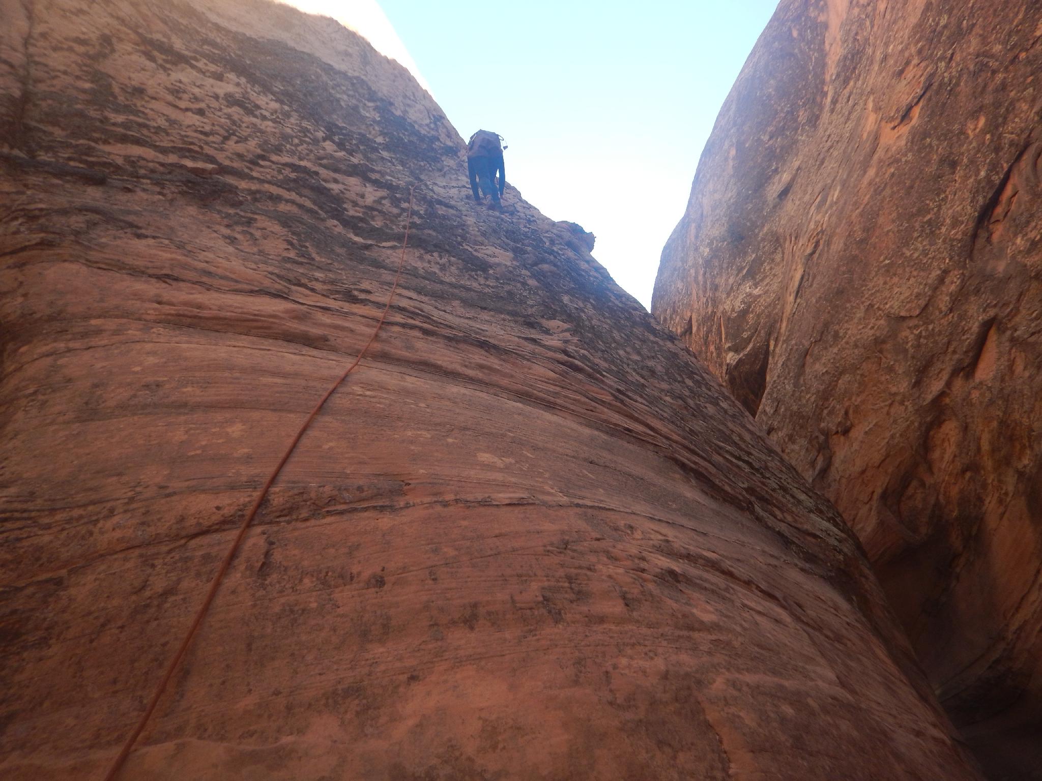
The route from the Burr Trail road is about 5 miles to Halls Creek. En route, there isn't much shade, and the terrain is difficult to navigate. GPS or excellent map and compass skills required to find the top of the Rubble Pile. Though only 5 miles, expect 3-5 hours for the approach/exit. In full heat of the summer, our group suffered mightily! Start early if it's hot!
From the trailhead, hike due west, descending into Long Canyon. Route find out of Long Canyon and continue west to the low point on the ridge above and a large mushroom shaped rock. There are many options here, but crossing Long Canyon may require a bit of route finding. The route marked on the map seemed easiest.
From the ridge, the Waterpocket Fold is visible to the west. The route finding gets a bit trickier here. From the ridge, go in a west/southwest direction and down a shallow drainage that soon coalesces with a more major drainage at a tamarisk surrounded seep. Go down the more major drainage to a small dryfall where the wash changes layers.
At the top of the dryfall, leave the wash and head due west. The route will cross over a ridge, and descend into another drainage, hopefully right across from another drainage with a few trees near the bottom. Go up the drainage and climb out on the left at a reasonable spot. Once out, continue west/southwest to the top of the rubble pile. Two cairns, one on each side of the small saddle, made finding the top of the rubble pile easy once within proximity of it.
From the top of the rubble pile, follow a cairned and emerging trail down. It traverses right (north), descends steeply through a band, then cuts left (south) along a shelf until an easy low angle path is found down to the Halls Creek social trail below. There are no difficult spots, so if you end up finding climbing problems, look around for an easier path.
Once on the Halls Creek social trail, go left (south) to the first major slickrock dome just right of the trail. Leave the trail, skirt around the dome on the west side, and find an easy descent route into Halls Creek. Once in the creek, it is a short distance to Millers Creek coming in on the right.
Approach to Smiling Cricket (1.5-2 hours from Millers Creek)
From Millers Creek, hike down Halls Creek. The first side canyon coming in is Happy Dog; then Halls Creek cuts through a band of sandstone. After this band, work up and west (right) out of Halls Creek on a social/cow trail. The trail crosses Laughing Baboon Canyon, either at a spring or a densely vegetated section. Just after crossing Laughing Baboon, begin route-finding west up the Waterpocket Fold.
The approach is complex. It is very easy to get suckered too far left and have a seemingly endless maze of slickrock to navigate. Stay a bit north (right as you head up). A drainage that runs east/west was our choice for the upper route, and it worked well (shown on the map). Once up, go south, crossing the head of Jiminy Cricket. At this point, a large red dome is visible a fair distance to the west, and a smaller white dome is visible to the south along the canyon rim. Go to the left (east) of the white dome and route find down into Smiling Cricket.
Canyon (9+ hours)
Smiling Cricket is a difficult canyon to give a detailed account of because water levels will change the number of rappels and anchors used. The highlights are given here and provide enough information to keep track of where you are.
Just down canyon from the entrance is the first obstacle, a short drop into a semi-keeper. We had the last man jump on our trip. If the water is not deep enough, an anchor will need to be found.
The obstacles come in quick succession from here.
Rappel 1 - 10 m ( 33 ft. ) off a slung chockstone;
Rappel 2 - A very short 5 m ( 17 ft. ) drop into a likely pool
Rappel 3 - A bigger 12 m ( 40 ft. ) drop, check the anchor carefully.
Rappel 4 - 10 m ( 33 ft. ) to a pothole. Partner assist.
Rappel 5 - 10 m ( 33 ft. ) into a likely pool. Swim under the amazing arch.
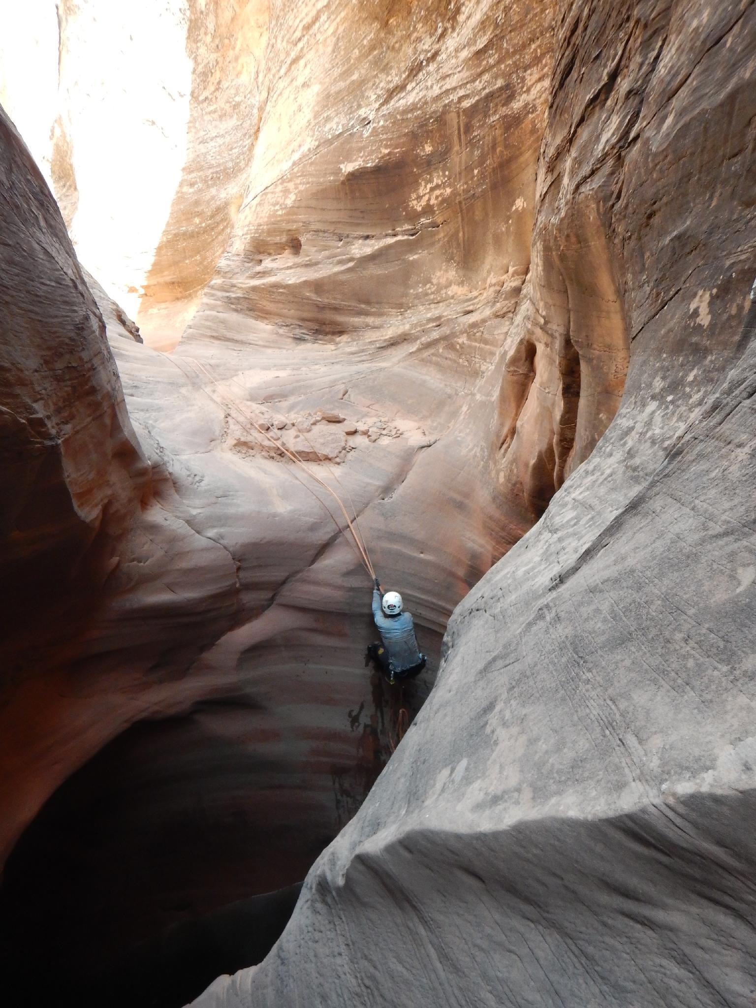
Rappel 6 - A big one, we linked the next two drops off a sandtrap for about a 25 m ( 83 ft. ) rappel. Be mindful of the pull. A Fiddlestick could be used on the arch instead of the sandtrap.
The canyon relents a bit and opens for a short section. Avoid the monster potholes with a little easy 5th class climbing up the left side to get around them. This more open area is a good spot to hydrate and fuel up. I would put the distance in the canyon at maybe close to 1/2 here, but timewise maybe 1/3.
Rappel 7 - Just down from the open area is a 10 m ( 33 ft. ) rappel into a keeper. Potshot toss before entering.
Rappel 8 - 25 m ( 83 ft. ) rappel with a pothole part way down.
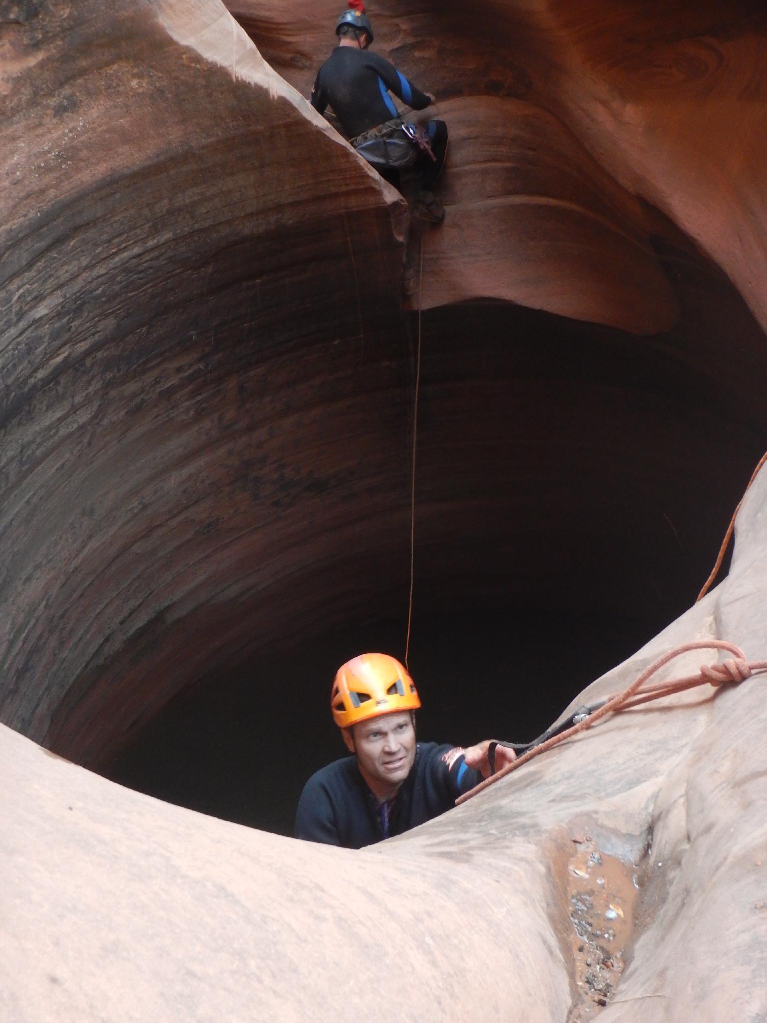
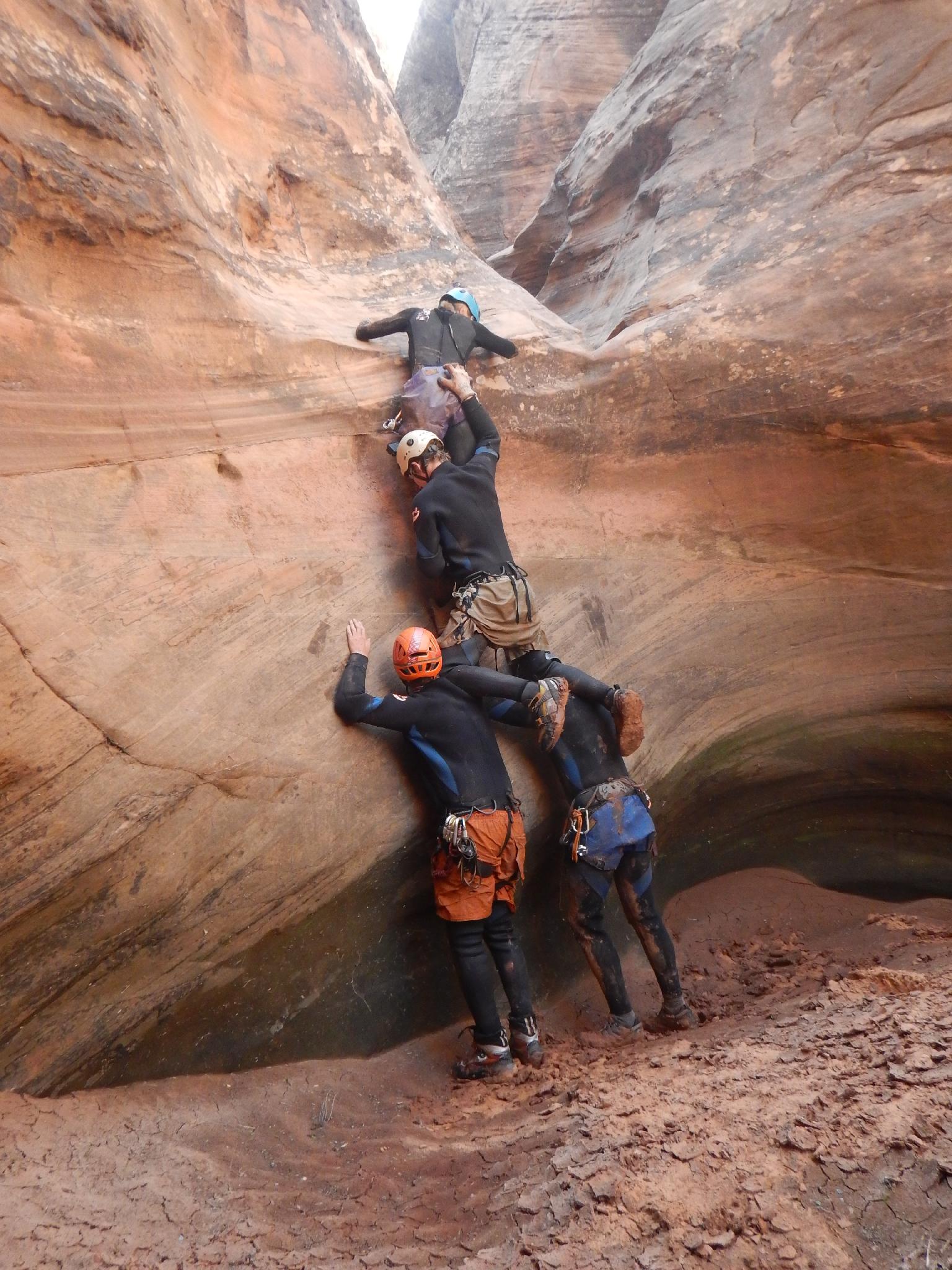
A pothole or two leads to the dramatic Mouse In A Bucket Pothole that is about 10'x10'. In our group, Taylor ran the right side (looking down canyon). Everyone else rapped in and ascended out. Easy potshot toss if needed. A few downclimbs and narrows present themselves after the Mouse In A Bucket Pothole.
You are nearing the Pit of Despair after the Mouse pothole. As soon as the right wall begins to lower, start keeping an eye out for good sand to fill the potshots with.
The Pit of Despair
So, you've finally reached the Pit of Despair. It is an amazing place. You have two options, through the pit, or over the pit.
Through The Pit of Despair
Got a good throwing game? Most people go into the pit, but it requires about a 45-50' potshot toss from a stemming position. Before our trip, I solicited as much input from those that have done it as I could. Here are some tips:
- Bags should be 1/4 to 1/3 full. More than that and they are too heavy to throw far.
- Minimize the arc by throwing flatter. The arc should maybe go slightly above your head, but not much. A bigger arc loses distance to height.
- The thrower should have 1-2' of rope out to throw with so the bag gets more pendulum action.
- The throwing position is awkward; have someone provide a stable spot for the throwers left foot (holding by hand, or chimney up so they can stand on a shoulder).
- 5-6 bags is recommended unless the escape person is very light.
- Bring extra bags in case some explode during the throw.
- Have someone below the thrower with the rope coiled to throw just BEFORE the thrower throws the bag. (like a second or less)
- Be mindful when pulling back failed throws, rope grooves are developing. Pull back from the very edge to minimize further grooving.
Keep in mind, many groups have spent 4-6+ hours and dozens of attempts making these throws. Taylor on our trip nailed about 5 out of 8, and it still took us 2 hours to get everyone through the obstacle. I tried twice to get a feel for it. The first one didn't cross the pit; the second came up about 6' short of the mark. You need to throw across the pit, across the patio, and into the small constriction beyond.
Over The Pit of Despair
Chimney up to the throwing position and look on the right wall (looking down canyon). An initial hook hole isn't too bad; then there is a cluster of hook holes just above where clearly one or two have blown out, followed with 1-2 more. At the top of the hook holes, mandatory free climbing is required to reach the single, old bolt anchor. (total exposure > 25') From the old anchor, lower and pendulum to the anchor farther down the canyon. Next either throw bags from there or lower and pendulum past the pit.
All-in-all, hope you can throw and don't have to take the high road.
If there is enough water, jumping into the pit for the last man on the way down is the way to go. If not, create an anchor to rappel into the pit. It will require potshots or a sandtrap. Be mindful of the pull (rappel 9).
Continuing Down The Canyon
Phew! You can relax a bit! The hardest part is over. Heading down canyon another pothole may require an assist.
Next up is a pothole that will require a rappel into. Throw a bag first and/or use ledges on the right to climb out (rappel 10).
Down the canyon a short distance is a big 23 m ( 76 ft. ) rappel into a pothole (rappel 11). If dry, a partner assist works great to get out. If the water level is uncooperative, you may need to toss potshots from 1/2 down the rappel.
Home stretch! The wormhole/wart are just down canyon a minute from Rappel 11. The Wart is usually defeated by having the first member of your group climb up to the Wart and rappel down past the Wormhole Pothole. They then provide a downstream anchor for a tension traverse across the Wormhole for the rest of the group. The last man rappels into the Wormhole and ascends out the other side. Be very careful with the Wart, it is exposed to get to and looks to be ready to fall off at any moment. If needed, potshots should be thrown instead of having someone do the climb.
The downstream side of the Wormhole is the anchor for the final two rappels. The first is about 20 m ( 66 ft. ) from a single bolt to a bowl with a 2-bolt anchor. It is about 42 m ( 138 ft. ) from the anchor to the ground. None of the bolts inspire much confidence. Using a sandtrap can make these two final rappels into one 60 m ( 197 ft. ) rappel.
Exit (1 hour)
You made it! Bushwhack downstream, avoiding the posion ivy as much as you can. If sensitive, you may want to stay in a wetsuit until you are out the canyon bottom. We stayed on the left side, in the water, then climbed out easy 5th class as soon as possible. Our climb out was just across from black streaks coming down on the right wall. Or, just fight your way down to Halls Creek in the bottom of the drainage. Turn left and wander back up Halls Creek to Millers Creek and your well deserved camp.
Photos
Maps
 Approach")
 Canyon")
12S 517759E 4163248N
37°36'58"N 110°47'56"W
12S 515805E 4162262N
37°36'26"N 110°49'15"W
12S 514933E 4161875N
37°36'14"N 110°49'51"W
12S 513644E 4161024N
37°35'46"N 110°50'44"W
12S 512131E 4160207N
37°35'20"N 110°51'45"W
12S 512080E 4160298N
37°35'23"N 110°51'47"W
12S 512016E 4160303N
37°35'23"N 110°51'50"W
12S 511992E 4159968N
37°35'12"N 110°51'51"W
12S 511826E 4159911N
37°35'10"N 110°51'58"W
12S 511536E 4158844N
37°34'36"N 110°52'10"W
12S 511335E 4158564N
37°34'27"N 110°52'18"W
12S 511412E 4157673N
37°33'58"N 110°52'15"W
12S 511539E 4156994N
37°33'36"N 110°52'10"W
12S 510327E 4157024N
37°33'37"N 110°52'59"W
12S 510248E 4156682N
37°33'26"N 110°53'02"W
12S 510249E 4156658N
37°33'25"N 110°53'02"W
12S 511099E 4157049N
37°33'37"N 110°52'28"W