 Roadside Attraction
Buckhorn Wash Art Panels
Roadside Attraction
Buckhorn Wash Art Panels
San Rafael Swell
Overview
Buckhorn Wash has some phenomenal petroglyphs and pictographs and is one of the most popular roadside attractions in the San Rafael Swell. All panels have easy access, and should be accessible to most. Visiting Buckhorn Wash is a great family outing any time of the year, and one I highly recommend. In addition, the towering walls and vibrant colors that make up the walls of Buckhorn Wash are stunning and worth visiting in their own right.
Getting There
You can access Buckhorn Wash from either the north or south. Either route is passable by car under most conditions.
Route Description
Rock art and historic sites are fragile, non-renewable cultural resources that, once damaged, can never be replaced. To ensure they are protected, please:
- Avoid Touching the Petroglyphs: Look and observe, BUT DO NOT TOUCH!
- Stay on the Trails: Stay on the most used trails when visiting sites, and don't create new trails or trample vegetation.
- Photography and Sketching is Allowed: Do not introduce any foreign substance to enhance the carved and pecked images for photographic or drawing purposes. Altering, defacing, or damaging the petroglyphs is against the law -- even if the damage is unintentional.
- Pets: Keep pets on a leash and clean up after them.
- Artifacts: If you happen to come across sherds (broken pottery) or lithics (flakes of stone tools), leave them where you see them. Once they are moved or removed, a piece of the past is forever lost.
There are many great attractions in Buckhorn Wash. Below is the mileage either from the top of Buckhorn Wash (northern approach) and the bottom of Buckhorn Wash (southern approach).
0.0 From the South / 9.6 From the North
Cattle guard.
3.8 From the South / 5.8 From the North
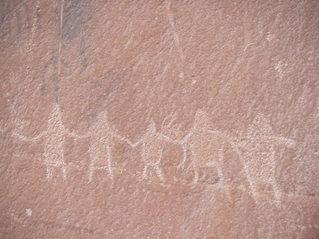
Buckhorn Wash main panel. This area has information signs, a pit toilet and is an excellent place for a picnic lunch. The panel used to be heavily vandalized but has been restored in recent years. Please treat the area with respect, and do not touch the rock art.
4.7 From the South / 4.9 From the North
A pullout and side road on the right. This area has several campsites and a deep alcove/cave you can see from the road. The cave is very soot-covered, but there are no pictographs/petroglyphs around it. The smoke may be from recent campers setting fires in it.
5.3 From the South / 4.3 From the North
Matt Warner inscription on the right high on the cliff. Matt Warner was one of the bandits that roamed the area back in the old days.
7.2 From the South / 2.4 From the North
There used to be a cattle guard here; now there is a signed pullout on the right for a short hike to a fantastic panel. Keeping with history, I'll call it the cattle guard panel. The short walk is accessible to most and recommended.
7.48 From the South / 2.1 From the North
A large angled boulder is easily visible on the west side of the road. Behind this boulder and up the slope is a black rock with several pictographs on it. I have heard there are not authentic, but are a short minute walk from the road to check out either way.
7.52 From the South / 2.05 From the North
A side road on the east side goes down to a camping area. Across Buckhorn Wash from the camping area, near the initials, TKG that were created with gunfire is a petroglyph panel. The panel is a minute walk almost directly across from the camping area.
8.05 From the South / 1.51 From the North
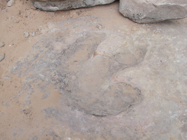
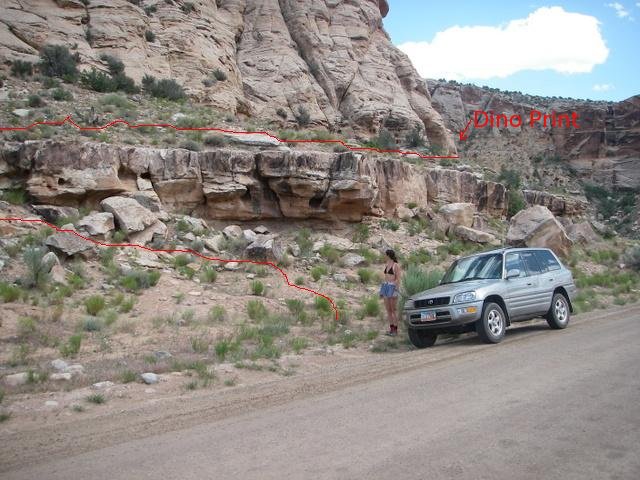
A pullout just up canyon from a bend leads to a trail that ascends a short distance above the road on the east. There is a dinosaur track here on the slickrock floor if you look carefully.
8.54 From the South / 1.03 From the North
Large pullout on the west side of the road with a large informational sign about MK Tunnels. This pullout is also the Ruin Arch trailhead
Morrison Knudsen Tunnels
In 1947, the Department of Defense started a project to construct deep tunnels in the Navajo Sandstone formation in Buckhorn Wash. The company contracted to do the work was the Morrison Knudsen Corporation. It took the company four years, with a sizeable local labor force to construct 4 tunnels in upper Buckhorn Wash.
After completion, the tunnels were detonated with 320,000 pounds of explosives. The ultimate purpose of the project has not been revealed to the public. Given the Cold War era, and fact similar tunnels and testing took place in other areas of the west, it seems safe the assume the DOD was trying to determine the best geology for underground military facilities such as Cheyenne Mountain Complex in Colorado that was built in the late 1950s.
The short hike visits the now gated tunnel that is visible from the parking area.
Ruin Arch
Hidden from all but the very observant, there is an arch and petroglyphs high above Buckhorn Wash near the Morrison Knudsen Tunnels. From the tunnel trailhead, follow the trail across the wash. Where it begins climbing up to the mine, go left, down Buckhorn Wash. Keep on eye out on the right for the first place a dirt slope goes up to what appears to be an alcove.
There is a well worn social trail here, follow it as it climbs the dirt slope, and then slickrock to the arch. There are petroglyphs near the arch, as well as a small wall that I would bet was done more recently. The arch has excellent views of Upper Buckhorn Wash and is very photogenic.
9.6 From the South / 0.0 From the North
Top of Buckhorn Wash.
Photos
Maps
")
")
")
12S 521492E 4335774N
39°10'15"N 110°45'04"W
12S 522864E 4335175N
39°09'56"N 110°44'07"W
12S 522801E 4335018N
39°09'51"N 110°44'10"W
12S 523021E 4334860N
39°09'46"N 110°44'01"W
12S 523394E 4334621N
39°09'38"N 110°43'45"W
12S 524071E 4334208N
39°09'24"N 110°43'17"W
12S 523875E 4334200N
39°09'24"N 110°43'25"W
12S 523907E 4334175N
39°09'23"N 110°43'24"W
12S 524182E 4334103N
39°09'21"N 110°43'12"W
12S 524134E 4333983N
39°09'17"N 110°43'14"W
12S 525631E 4332042N
39°08'14"N 110°42'12"W
12S 526160E 4331641N
39°08'01"N 110°41'50"W
12S 525969E 4331530N
39°07'57"N 110°41'58"W
12S 526450E 4330521N
39°07'24"N 110°41'38"W
12S 529066E 4326048N
39°04'59"N 110°39'50"W