
 Mount Irish Archaeological District
Alamo
Overview
Mount Irish is one of the rock art areas that Lincoln County and the BLM both publish information on. Tucked up near the 8,743 ft high Mt Irish, the site is among boulder outcroppings and washes. It is a large site. If you are interested in rock art, it is easy to spend a day or even more wandering around looking for rock art in the boulders. On my visit, I felt like I had just scratched the surface, yet still saw many fantastic glyphs and panels.
Pay attention to the road directions. For a BLM promoted site, the route there is surprisingly unsigned. I had a somewhat difficult time finding the correct roads! Some of the published information I found has incorrect mileages.
History of the Area:
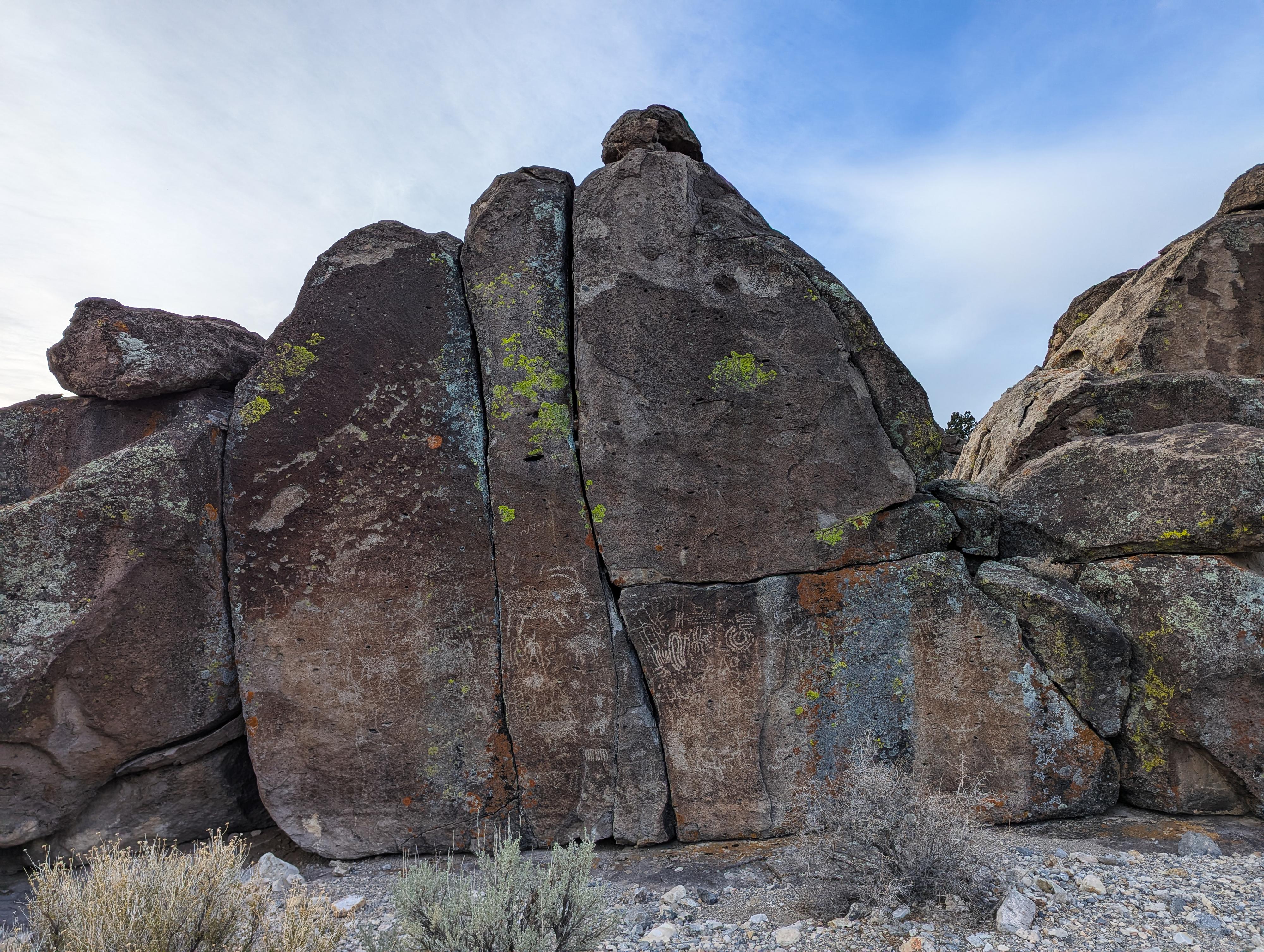
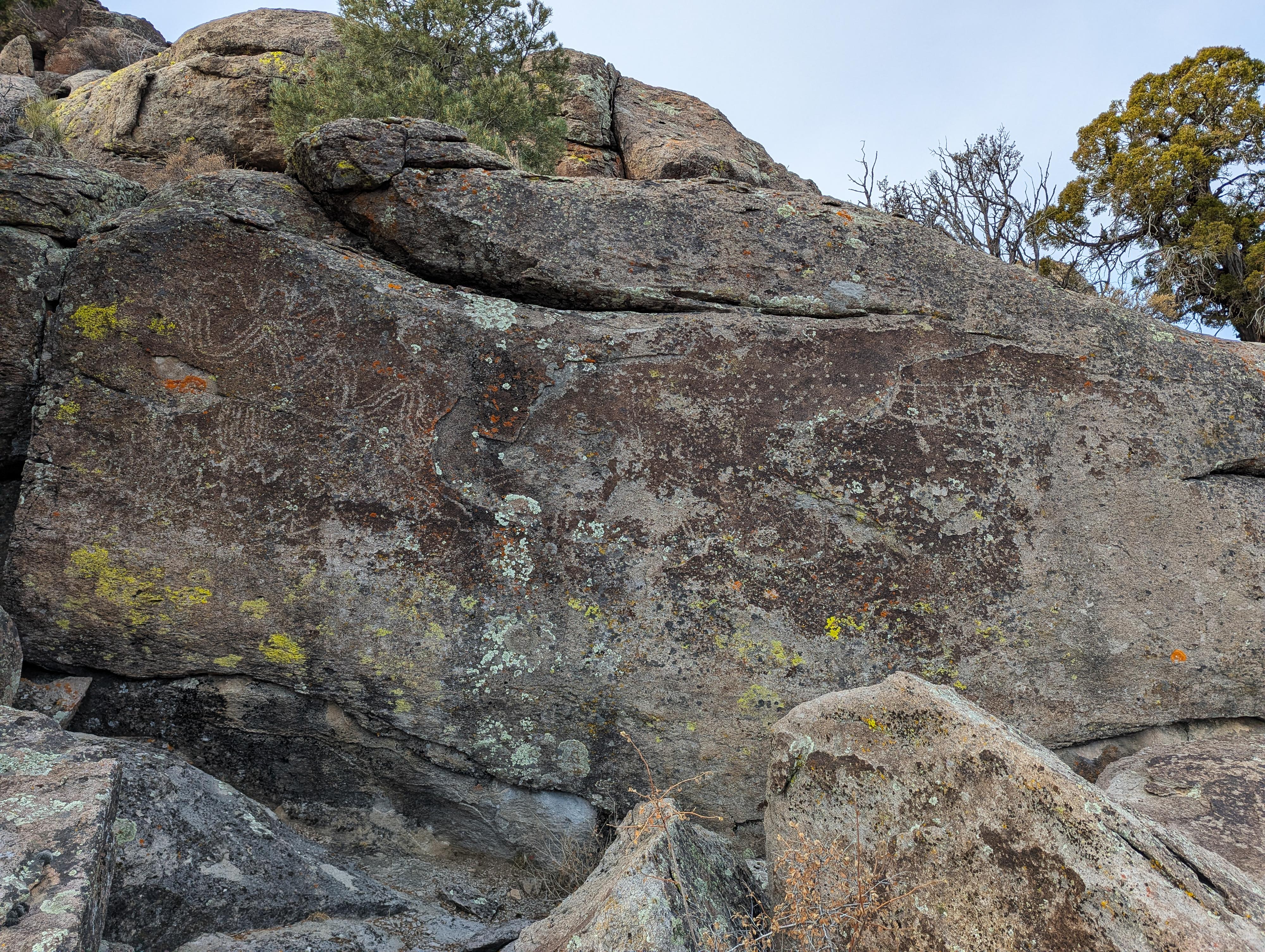
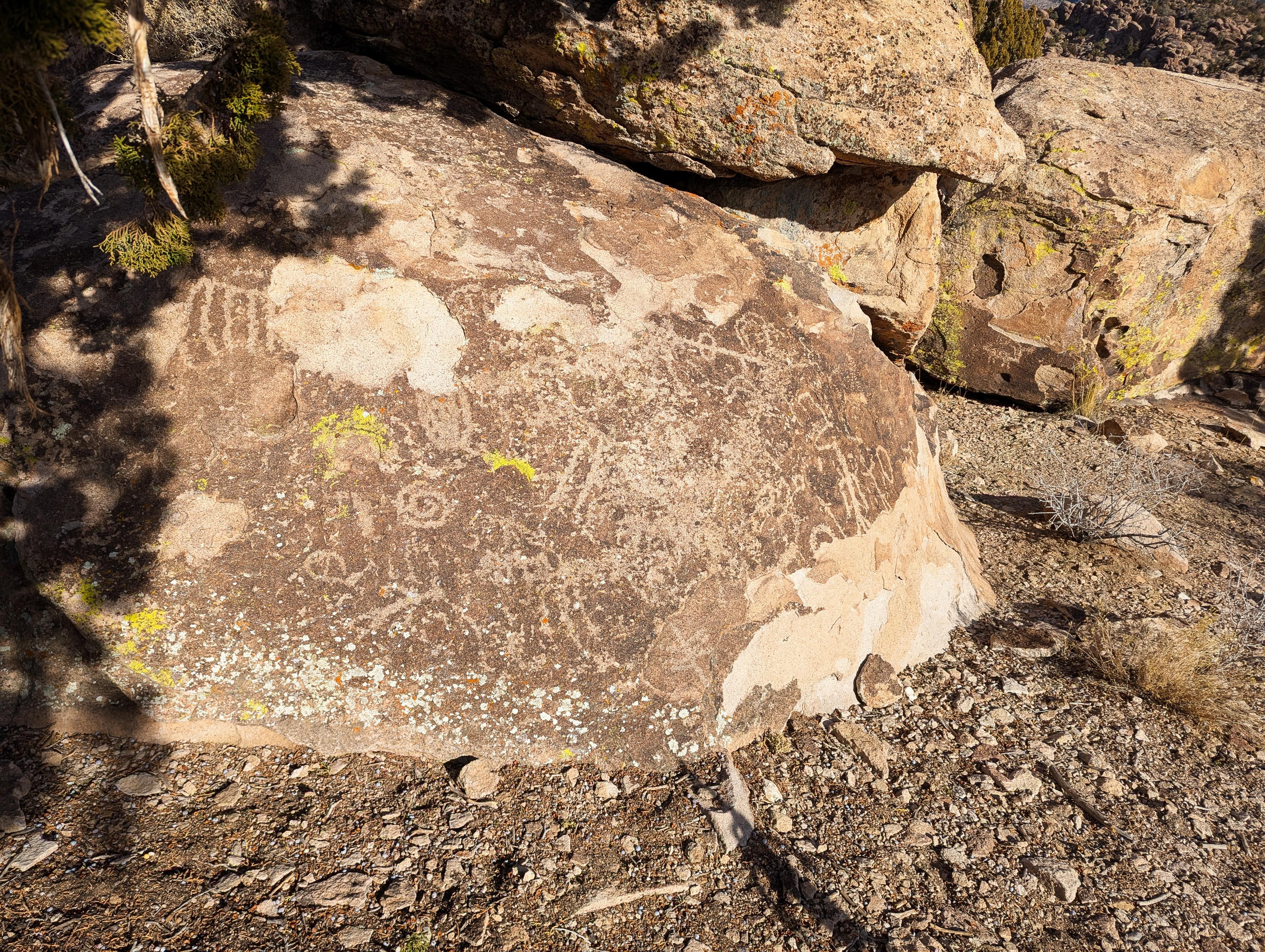
Mt. Irish is recognized as one of the most significant archaeological regions in eastern Nevada. Spanning 640 acres, the area features ancient rock art and historic habitation sites. These sites are believed to be up to 4,000 years old.
Before the arrival of Euro-American settlers in the 19th century, eastern Nevada was home to hunter-gatherer societies who made use of the area’s natural resources. With extensive knowledge of local plants and animals, these groups lived in family units and followed seasonal cycles to collect food and materials. They visited the Mt. Irish area repeatedly over millennia, using it as a base for hunting, gathering, and creating rock art. These visits began around 4,000 years ago, becoming more frequent and intensive between 2,000 and 500 years ago.
At Mt. Irish, artistic expression, habitation, and subsistence practices were closely linked. Many rock art sites are located near the remains of ancient campsites and food-gathering activities. Items such as stone tools, tool fragments, shelters, and middens indicate that food processing often occurred near the rock art itself. It remains a question whether the area's seasonal resources were the main attraction, or if the location held deeper cultural or spiritual significance. While the exact purpose and meaning of the rock art are still unclear, its continued presence underscores its importance to the people who created and used these ancient visual narratives.
Two primary styles of rock art are found at Mt. Irish. One, known as the Pahranagat Style, has unclear cultural origins and is largely confined to Lincoln County. This style represents human figures in two distinct forms: one shows oval or rectangular solidly pecked bodies with large eyes, short lines extending from the head, and long-fingered hands; the other features rectangular bodies filled with geometric shapes or lines, paired with stick-like limbs. Some figures appear to hold tools resembling atlatls (spear throwers), suggesting these images may date to before the widespread use of the bow and arrow roughly 1,500 years ago.
The second style, tied to the Basin and Range tradition, includes more abstract and stylized depictions—such as stick-figure humans and a wide variety of animals, especially bighorn sheep. In fact, the Mt. Irish District holds one of the highest concentrations of bighorn sheep rock art in eastern Nevada, with nearly half located at Mt. Irish VI alone.
Logan City: Logan City is just a couple of miles west of Mt. Irish and is a fascinating place to visit as well. It is described in this trip as well and worth the short side trip.
Getting There
From Alamo, NV, head north on US-93 for about 12 miles to its junction with NV-318 on the left. Turn onto NV-318 and reset your odometer. In about 0.6 miles, NV- 375 leaves on the left and heads west toward Rachel. Stay on NV-318 instead, which bends and heads north. 7.1 miles from the junction of US-93 and NV-318, the Logan Canyon Road leaves on the left, across from Nesbitt Lake. Reset your odometer as you turn onto this good, graded dirt road with a wire gate. The road had a small BLM sign next to it mostlu hidden in the weeds on my visit, but is basically unsigned.
Route Description
Rock art and historic sites are fragile, non-renewable cultural resources that, once damaged, can never be replaced. To ensure they are protected, please:
- Avoid Touching the Petroglyphs: Look and observe, BUT DO NOT TOUCH!
- Stay on the Trails: Stay on the most used trails when visiting sites, and don't create new trails or trample vegetation.
- Photography and Sketching is Allowed: Do not introduce any foreign substance to enhance the carved and pecked images for photographic or drawing purposes. Altering, defacing, or damaging the petroglyphs is against the law -- even if the damage is unintentional.
- Pets: Keep pets on a leash and clean up after them.
- Artifacts: If you happen to come across sherds (broken pottery) or lithics (flakes of stone tools), leave them where you see them. Once they are moved or removed, a piece of the past is forever lost.
Road Junctions, marked on the map, are good landmarks. The descriptions below will use the mileage junctions for breaking up the hikes.
6.5 miles - A rock art site can be visited by walking or driving on this left road to where it crosses the wash, then walking up the wash about a 1/4 of a mile (5 minutes). The site is on the left side of the wash. The road is fairly rough and the walking short, so I would recommend walking.
6.85 miles - To the south, about 150 feet from the road across the wide wash, is a large monolith of stone. This has an exceptional panel, one of my favorites in the area.
7.6 miles - Side Road. From the parking spot 0.6 miles down the side road from the main road, there is a large rock outcropping to the north. There are several sites here. On the east and northeast side of the rocks, I found several good panels, but they can take a bit of looking around to find.
8.15 miles - Campground - In addition to a campground and pit toilet, there is a signed trail that leaves the campground on the south side. It may still be under construction, but in December 2024, the trail when down to the wash, then appeared to follow the wash upstream. I went about 1/2 mile up the wash before turning around. It could easily be followed up to Shaman Knob. I didn't see any rock art in this area.
8.6 miles - A large Mount Irish Petroglyph site is on the right, with a small parking area. From the parking area, there are numerous numbered rock art panels around the large rock outcropping just east of the parking area.
8.9 miles - Shaman Knob. The side road on the left goes about 800 feet to Shaman Knob. This can be walked if too rough, but it is generally in good shape. At the parking area, Shaman Knob is to the southeast, and has rock art on it. In addition, be sure to explore the side of the road opposite Shaman Knob. There are several petroglyphs there as well.
9.6 miles - Logan City Junction - Go left here for about 1/3 of a mile to a couple of old building and some old foundation and rubble piles. This is Logan City.
Logan City was the largest of four mining camps established in the Pahranagat Mining District. In 1865, Logan Spring was home to the first official meeting for the District. Logan City quickly grew and by 1867, there was a post office, store, hotel, stable, and a population speculated to be about 300. The boom was short-lived. Given the relatively poor silver production in the District, and promising discoveries found elsewhere, the town was abandoned by 1871.
Spring
Logan Spring has attracted Native Americans, miners, and ranchers for thousands of years and continued to be used long after the mining camp was abandoned. The most prominent individual at post-boom Logan City may have been Adin W. Geer, a rancher, farmer, and independent miner from Pahranagat Valley, Betten 1889 and 1911, he developed a land patent on the area surrounding Logan Spring and used the water for mining, domestic purposes, and watering between 10 and 100 animals (probably cattle) year-round.
Springtime runoff flows through the Mt. Irish Archaeological District, and local ranchers still water their cattle at the spring.
Where are all the buildings?
Due to the continual reuse of materials at Logan City by later miners and ranchers, the original camp structures are unrecognizable today.
By 1970, the only buildings standing at Logan City were part of the Schofield home. These buildings were constructed with re-purposed materials and plywood. The Schofields started mining aluminum silicate deposits in the banded rhyolite bluff overlooking Logan City in 1955.
There are rock piles and walls scattered across the area that outline the locations of previous structures but their actual dates of use are unknown.
Pahranagat Mining District
Logan City was part of the Pahranagat Mining District. The District was established in 1865 after a local Native American confirmed that silver ore could be found at Mt. Irish. Between 1866 and early 1867 the District peaked in silver production and had a population of approximately 500. By 1868, it was estimated that nearly a million dollars had been spent in the district but only $20,000 in bullion had been shipped. With resources drying up and new strikes made in nearby Panaca and Pioche, the Pahranagat Mining District population dwindled. In 1869, William Raymond and his partner John Ely, who had owned the largest mines in the district, dismantled their stamp mill at Hiko and moved it to Bullionville near Pioche. In 1871, the county seat moved from Hiko to Pioche punctuating the end of the Pahranagat Mining District.
After the bust, prospectors continued to try their luck by collecting small pockets of ore overlooked by earlier developments, but the Pahranagat Mining District never experienced a true revival.
Photos
Maps

11S 646760E 4163134N
37°36'13"N 115°20'15"W
11S 646619E 4162934N
37°36'07"N 115°20'20"W
11S 646268E 4163313N
37°36'19"N 115°20'35"W
11S 646153E 4163270N
37°36'18"N 115°20'39"W
11S 645034E 4163060N
37°36'12"N 115°21'25"W
11S 644218E 4162625N
37°35'58"N 115°21'59"W
11S 644209E 4162637N
37°35'58"N 115°21'59"W
11S 644199E 4162642N
37°35'58"N 115°21'59"W
11S 644196E 4163028N
37°36'11"N 115°21'59"W
11S 643598E 4163359N
37°36'22"N 115°22'23"W
11S 643207E 4163583N
37°36'30"N 115°22'39"W
11S 643152E 4163414N
37°36'24"N 115°22'41"W
11S 642132E 4163881N
37°36'40"N 115°23'23"W
11S 641806E 4163659N
37°36'33"N 115°23'36"W