 Canyoneering
Munra Creek
Canyoneering
Munra Creek
Columbia River Gorge Oregon
Overview
This is a short tributary of Tanner Creek recommended as a good early season canyon. No mandatory swims, and relatively short, it also seemed like an overall good introduction to the area when we visited in late May of 2015. The canyon didn't disappoint! A casual approach and exit, coupled with an absolutely stunning section of canyon, make for a great day out, in what feels like deep in the backcountry. The final rappel over Lower Munra Falls drops you down to a wooden bridge on the trail that visits Wahclella Falls. This is a VERY popular trail and you are almost guaranteed to have throngs of hikers passing by as you show off your skill and prowess making the rappel. Like Mystery Canyon in Zion, the falls are slippery, which makes for a good spectacle for those passing by.
This is one not to be missed in the Columbia River Gorge, and an adventure I would highly recommend. Though only 1/2 mile in length and with 7 rappels, the going is very slow in the densely overgrown bottom of the canyon. Expect at least a 4-5 hour round trip, and most groups likely 5-6 hours. Though it MAY be possible to descend the canyon without a wetsuit on a very hot day, I would highly NOT RECOMMEND IT. Most of the rappels are near the edge of the falls and will be cold and wet no matter how hot the day is.
Getting There
The trailhead is reached from exit 40 on I-84 in the Columbia River Gorge. This is about 35 miles east of Portland. Take exit 40, and go south. Just after the highway, the road forks. Right goes into the Yeon State Park / Wahclella Falls trailhead. This is the exit trailhead; if you have 2 cars, you can leave one here, though you will have to pay the state park entrance fee.
To reach the trailhead, go left on the south side of the highway instead of into the Wahclella Falls trailhead. Follow the road 0.4 miles as it climbs up a hill and reaches a trailhead and larger parking area for Toothrock Tunnel, where there is no parking fee.
Route Description
Approach (2.1 miles / 1 hour)
From the parking lot, follow the paved road back a minute or two to the gravel road and water tank on the left (looking down the road). The gravel road is trail 401. Take the good gravel road, staying on it past several side trails and minor roads. It heads north, then bends back to the south. After about 2 miles, an old sign and bench are reached where trail #401 goes off on the left and the road continues. The creek that crosses the road here (the first creek you have seen since leaving the parking area) is Munra Creek. Check the culvert to make sure the flow is reasonable and something your group feels comfortable with.
Side Trip: Heading up trail #401 offers a few waterfalls within about 5 minutes. They are interesting and worth the short side trip.
Canyon (0.5 miles / 3-4 hours)
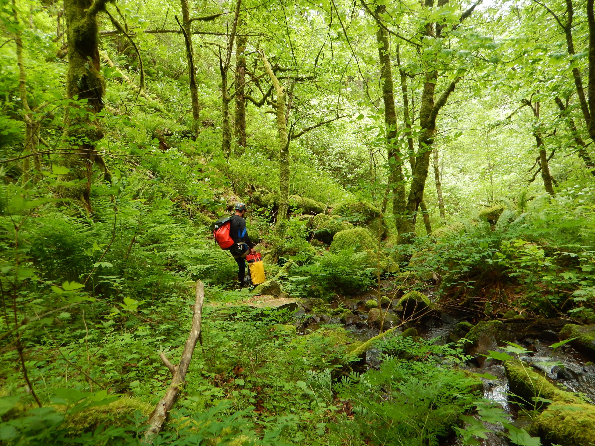
A faint social trail heads down canyon near the culvert. You will be crossing and in and out of the stream from here on out. Some groups may want to change into wetsuits here where it is easy and a bench is provided. It is 20 or so minutes to the first rappel. We opted to change here.
Splash and head downstream, crossing the stream many times. The path is lush and overgrown, making for slow going and requiring constant vigilance to avoid tripping. The canyon drops precipitously at the large first rappel.
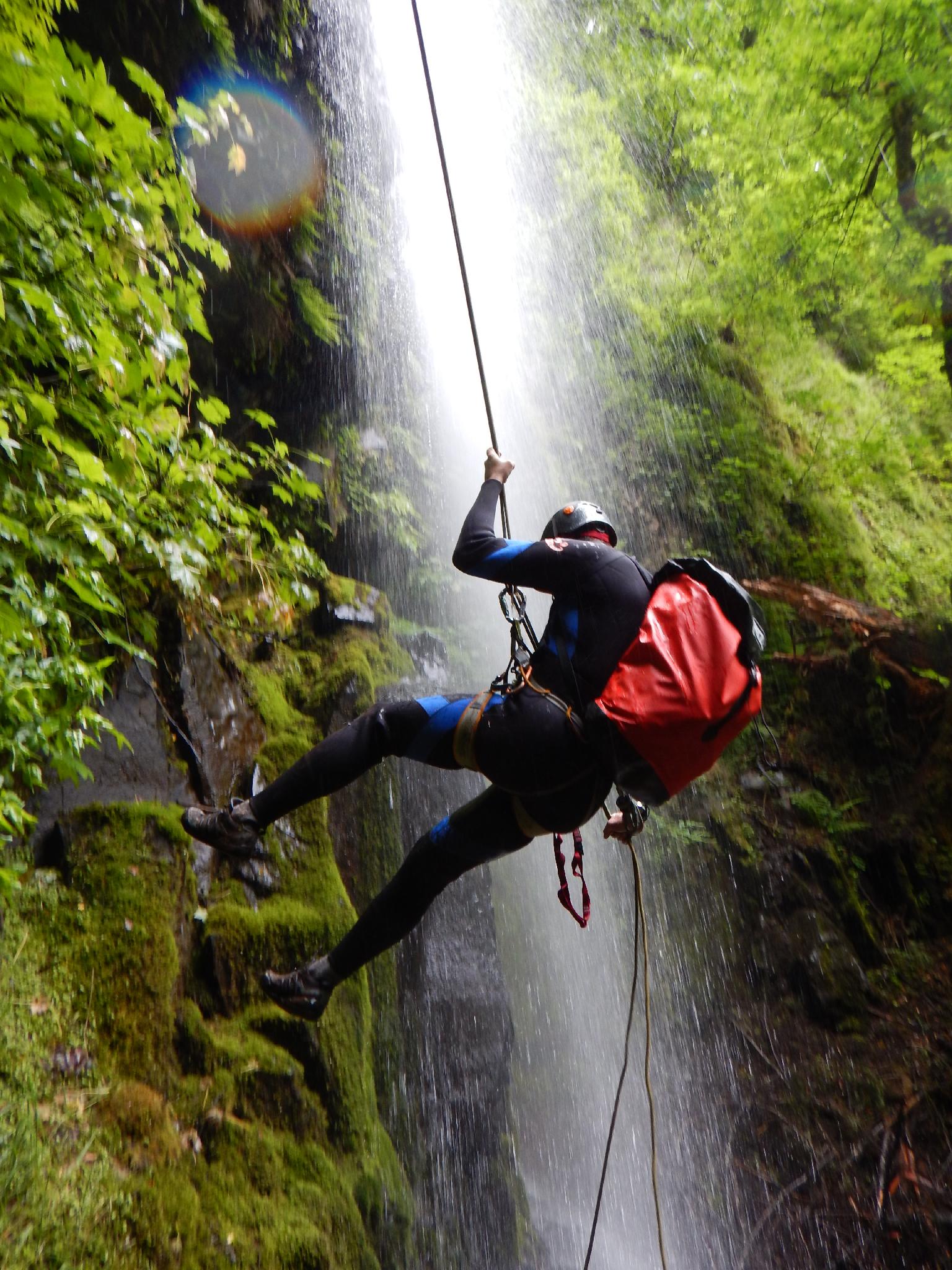
Rappel 1 - 33 m ( 109 ft. ) (Upper Munra Falls)
The first rappel feels big, and is off a tree on the right looking down canyon. Squeeze off the rappel below several tree branches. Ugg! From here on out, the canyon is a mix of walking and rappels.
Rappel 2 - 45 m ( 148 ft. )
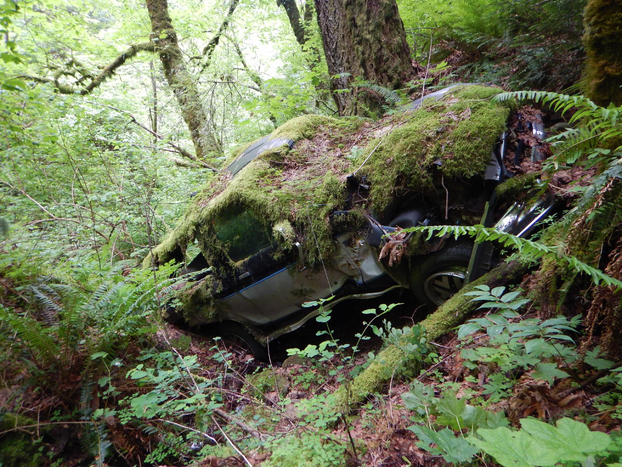
The canyon is easy going to the second rappel, passing an old wrecked car along the way. The second rappel is also big, and off a tree on the left, looking down canyon.
Rappel 3 - 20 m ( 66 ft. )
A tree a ways back on the left is the anchor here.
Rappel 4 - 12 m ( 40 ft. )
Immediately below rappel 3, this drop is anchored off a dead tree and bolt (in the watercourse?!?!). It deposits you in an exquisite short narrows section with a log downclimb immediately below. The canyon just gets better and better.
Rappel 5 - 15 m ( 50 ft. )
Currently this anchor is quite a ways back from the edge. You may want to extend it or rig something closer.
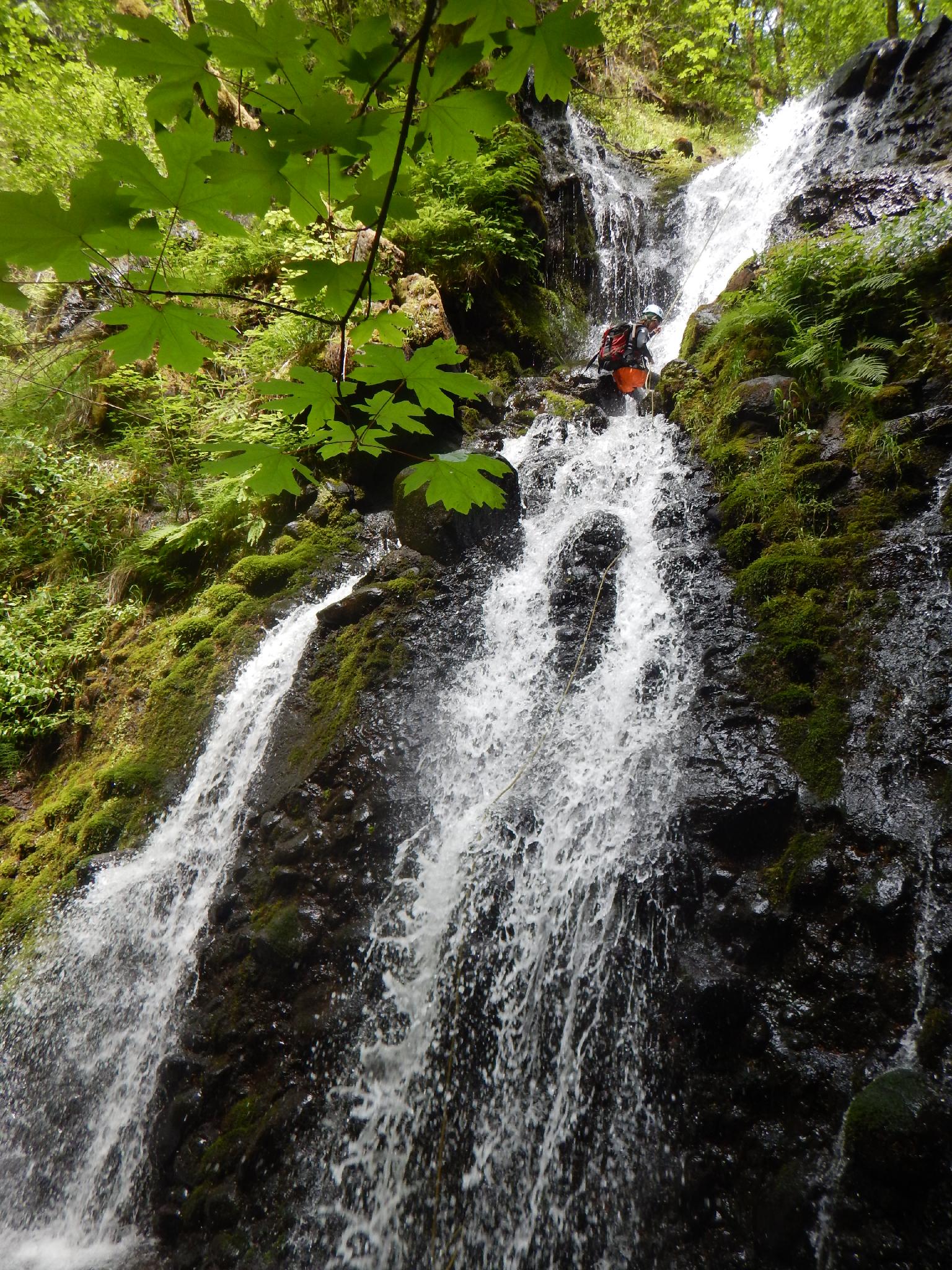
Rappel 6 - 20 m ( 66 ft. )
A stunning rappel down a two-tiered falls with a great area to get splashed in about 1/2 way.
Rappel 7 - 30 m ( 99 ft. ) (Lower Munra Falls)
All too soon, the canyon makes its final drop into Tanner Creek. The rappel is about 30 m from the current anchor. DO NOT THROW YOUR ROPE HERE! There are likely to be spectators below in the toss zone.
Exit (0.3 miles / 10 minutes)
Once down, take a bow, coil your ropes, and head down canyon to the exit trailhead. Or head up canyon to visit Wahclella Fall before heading down (0.75 miles up canyon one way).
Photos
Maps

10T 581969E 5053971N
45°38'04"N 121°56'54"W
10T 581846E 5053842N
45°37'60"N 121°56'60"W
10T 582375E 5053040N
45°37'34"N 121°56'36"W
10T 581579E 5053057N
45°37'35"N 121°57'12"W
10T 581527E 5053505N
45°37'49"N 121°57'15"W