
 Natural Bridges National Monument
Cedar Mesa
Overview
Natural Bridges is probably my favorite National Monument in Utah. It is famous for its three large natural bridges: Sipapu Bridge, Kachina Bridge, and Owachomo Bridge. All three bridges are viewable from view points along the scenic drive. I would strongly recommend at least making the short hikes down to visit each bridge up close. Doing one or several of the out and backs to a bridge is a good, family-friendly excursion. Even better, is to do a loop hike visiting 2 or all 3 bridges on the same hike and makes for an amazing day.
Also, several ruins and petroglyphs in the park give lots to explore and visit. On my last trip, I did the same hike two days in a row and felt like I saw very different things both days. Though many visitors simply drive the scenic drive, the short hikes and side attractions are what make Natural Bridges an amazing experience.
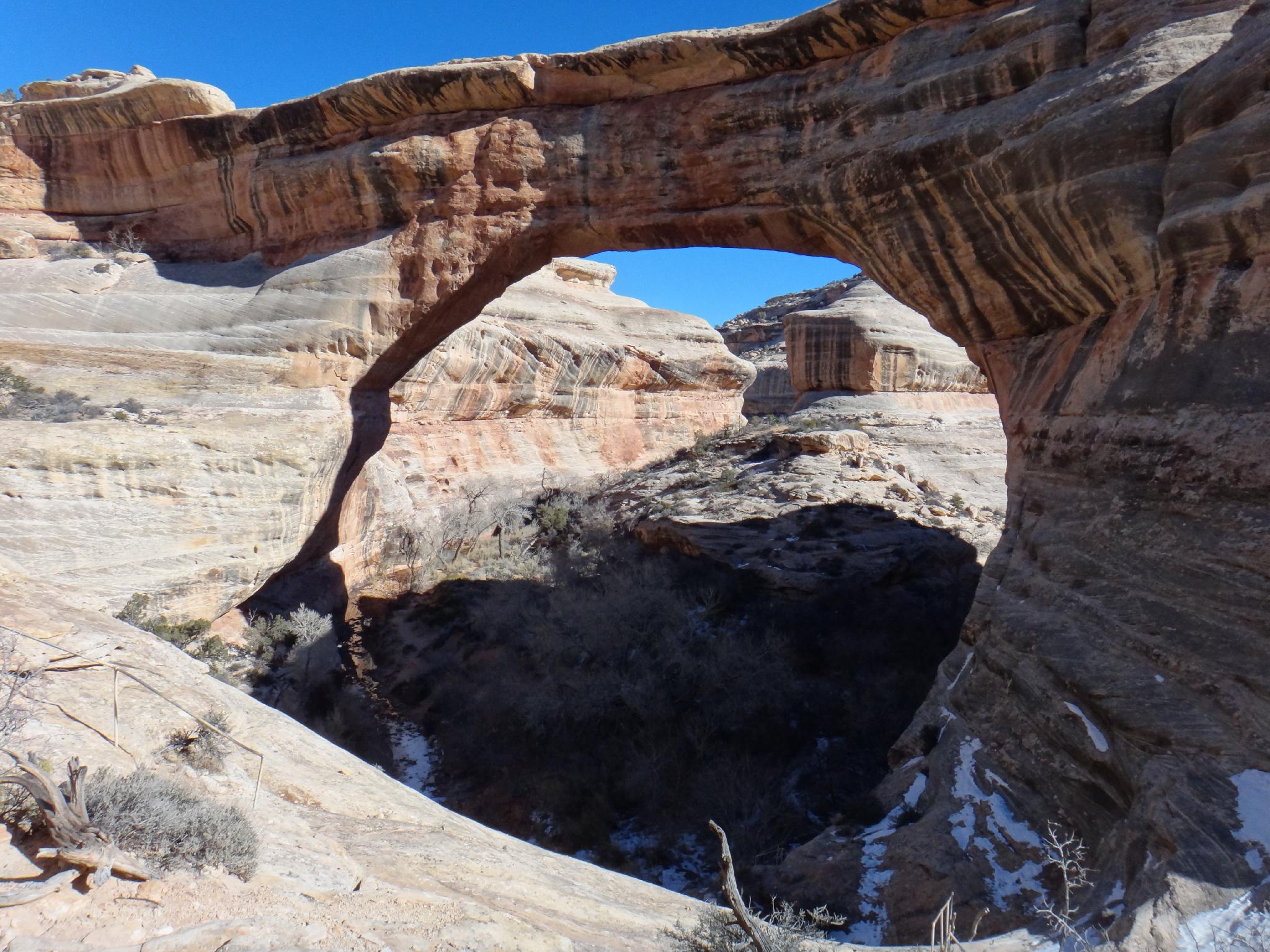
Sipapu Bridge
Though it used to lay claim to the fourth longest natural arch in the world, Sipapu was re-measured in 2007 and now is ranked seventh in the world at an impressive 225 feet. The hike to Sipapu goes down a short log ladder and longer metal ladder to an amazing and exposed viewpoint, before finally descending to the bridge proper. Sipapu is my favorite of the bridges, and the first part of the hike to the exposed viewpoint is well worth the effort.
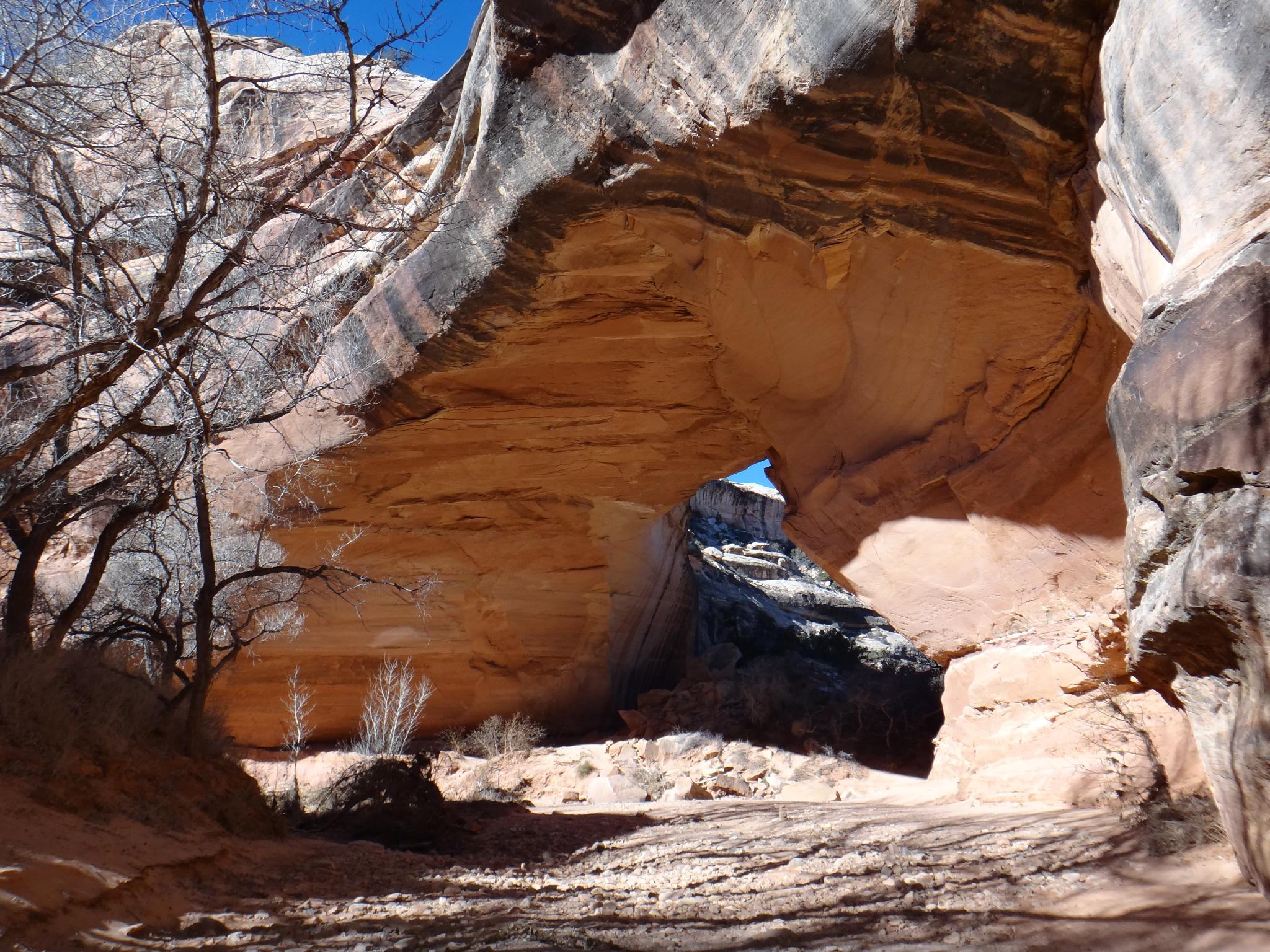
Kachina Bridge
Kachina Bridge is in between Sipapu and Owachomo both in terms of size and location. It is likely the least impressive bridge to visit, but that is more than made up for by several ruins and petroglyphs at the bridges base. A loop hike from Sipapu and out Owachomo is my recommendation for those wanting a 2-4 hour short hike.
Owachomo Bridge
Owachomo is the last of the bridges. Unlike the other two, which span White Canyon, Owachomo spans Armstrong Canyon. Owachomo means "rock mound" in Hopi. It is the easiest bridge to visit and used to be the entry point into Natural Bridges. From the base of the bridge, you can see the remains of the old trail in on the opposite side of the canyon from the current trail. This is named "Zeke's" trail after Ezekial "Zeke" Johnson, the first custodian of Natural Bridges. Visitors used to come from UT-95 and hike in here.
If doing a loop hike from Owachomo to Kachina, I would recommend doing it starting at Owachomo. There is a good ruin on a ledge that is easy to miss if coming from Kachina.
Getting There
From Blanding, go south on US-191 about 4 miles to it's junction with UT-95. Go west on UT-95 about 30 miles to the signed Natural Bridges road on the right. The monument is about 4.5 miles off UT-95.
From Hanksville, go south on UT-95 about 96 miles to the signed Natural Bridges road on the left. The monument is about 4.5 miles off UT-95.
Route Description
Rock art and historic sites are fragile, non-renewable cultural resources that, once damaged, can never be replaced. To ensure they are protected, please:
- Avoid Touching the Petroglyphs: Look and observe, BUT DO NOT TOUCH!
- Stay on the Trails: Stay on the most used trails when visiting sites, and don't create new trails or trample vegetation.
- Photography and Sketching is Allowed: Do not introduce any foreign substance to enhance the carved and pecked images for photographic or drawing purposes. Altering, defacing, or damaging the petroglyphs is against the law -- even if the damage is unintentional.
- Pets: Keep pets on a leash and clean up after them.
- Artifacts: If you happen to come across sherds (broken pottery) or lithics (flakes of stone tools), leave them where you see them. Once they are moved or removed, a piece of the past is forever lost.
The long loop hike visits the three bridges, then crosses back to the starting point via the Mesa Trail. If you have two cars or a mountain bike, you can avoid the Mesa Trail, which, in my opinion, detracts a bit from the outing. If taking that option, leave your shuttle at Sipapu Trailhead and hike the loop described in reverse, starting at Owachomo.
My Recommendation (9-miles / 5-6 hours)
From the Sipapu trailhead, follow the trail down. It descends two staircases before a viewpoint side trail goes off on the left a short distance to a fantastic overlook. Probably the best place for taking photos of Sipapu. Continue down the trail to the base of the bridge.
Go down White Canyon, keeping an eye high on the right for a ruin near the top of the cliff bands. It is not visitable from below. Not far below Sipapu, Deer Canyon comes in on the right. At the confluence of White and Deer is a pictograph panel on the west (right) side of Deer Canyon.
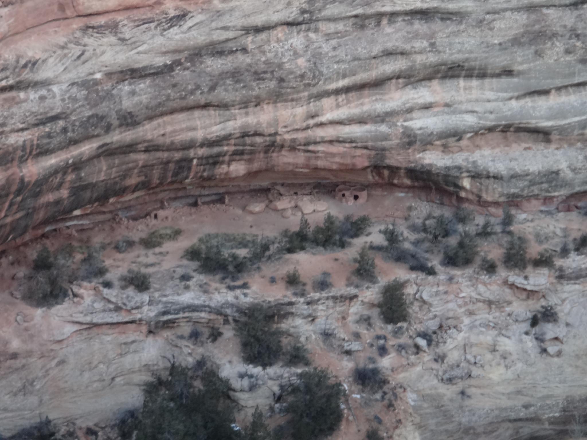
Less than 5 minutes below Deer Canyon is the Horse Collar Ruin on the right, just above the stream bed. It is in good shape and very interesting to visit. There is also an arch high on the left here that is easy to spot. Horse Collar Ruin was abandoned over 700 years ago. It has not been restored and shows the original construction methods. Be respectful when visiting to not cause damage.
From Horse Collar, it is 30 minutes or so to Kachina Bridge. There are petroglyphs on the west (left) side of the bridge as you approach it. More interesting, however, are the petroglyphs and ruins on the downstream side. Be sure not to miss them! Go through Kachina, and then follow a use trail up to the shallow alcove on the right. There are also a few pictographs and petroglyphs here.
From Kachina, the trail takes the left-hand canyon (Armstrong Canyon) and leaves White Canyon. A few minutes from Kachina, the trail climbs out of Armstrong up to a bench on the left. If you want a shorter hike, go left at the junction up to the Kachina Trailhead. For the full loop, got right.
Continuing to Owachomo, the trail stays on the bench until passing the obvious dryfall, then re-enters Armstrong. Going up Armstrong, a side canyon comes in on the left. It is a good landmark, one bend above it is a ruin in an alcove on the right side. The ruin is easy to miss if hiking toward Owachomo, but hard to miss if walking from Owachomo to Kachina. It would be moderately difficult to visit, best admired from below.
Easy passage leads to Owachomo. The old entrance trail is visible on the right, across from Owachomo, but to get to the Owachomo trailhead, go through the bridge and follow the trail up.
If you left a car shuttle, you are done. Otherwise take the Mesa Trail back to Sipapu. The Mesa Trail is uninspiring but goes pretty quickly.
Horse Collar Ruin Overlook
Just past the Sipapu Trailhead is the Horse Collar Ruin Overlook trailhead. This short (0.6 miles round trip) hike offers great views of Horse Collar Ruin from above and is recommended.
Maps

12S 587450E 4163351N
37°36'47"N 110°00'33"W
12S 586325E 4163221N
37°36'43"N 110°01'19"W
12S 585488E 4161849N
37°35'59"N 110°01'54"W
12S 586027E 4161179N
37°35'37"N 110°01'32"W
12S 585944E 4161681N
37°35'54"N 110°01'35"W
12S 586871E 4163186N
37°36'42"N 110°00'57"W
12S 587075E 4160245N
37°35'07"N 110°00'50"W