 Roadside Attraction
Temple Mountain Panels
Roadside Attraction
Temple Mountain Panels
Eastern Reef
Overview
Temple Mountain has a history of Uranium mining and is littered with old mining roads, tunnels, and other artifacts. Also, it has a large pictograph panel that, though weathered, is quite impressive and well worth the short stop.
The area near the panels has two large camping areas, with many dispersed camping areas in the area. This is a must see if visiting Goblin Valley, Little Wild Horse, or any of the other sights in this part of the Swell.
Information about the pictographs from the sign at the site:
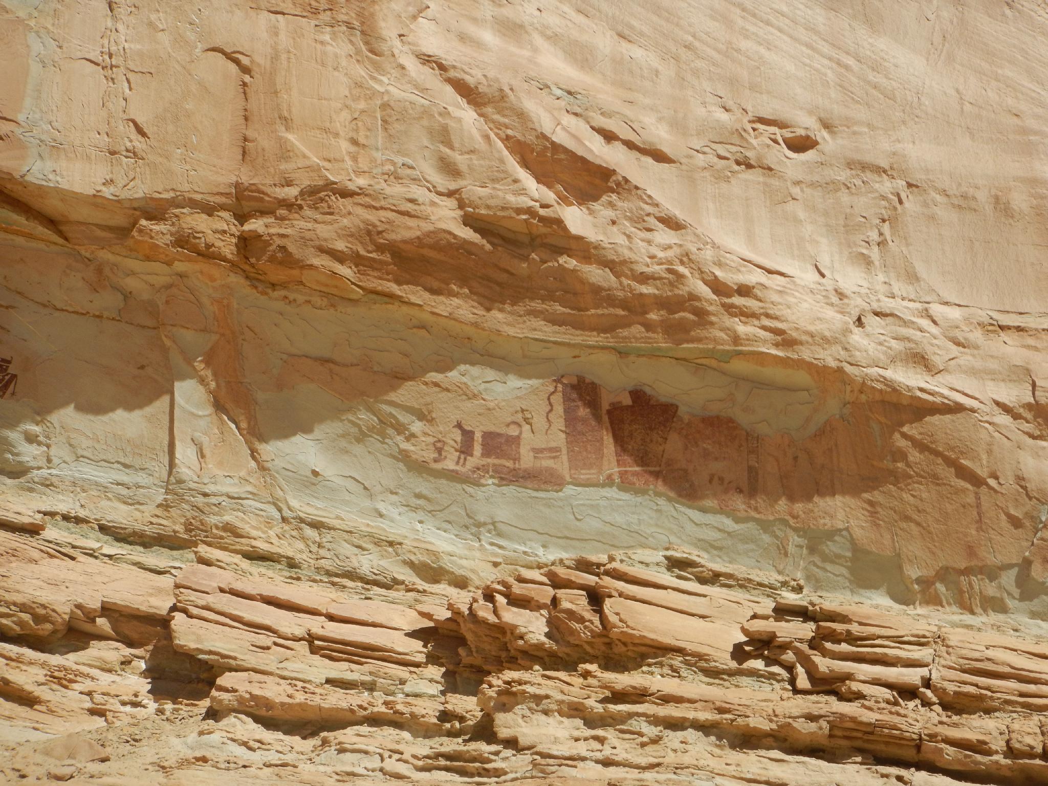
The Temple Mountain Wash Pictograph Panel
by Steve Manning,
Utah Rock Art Research Association
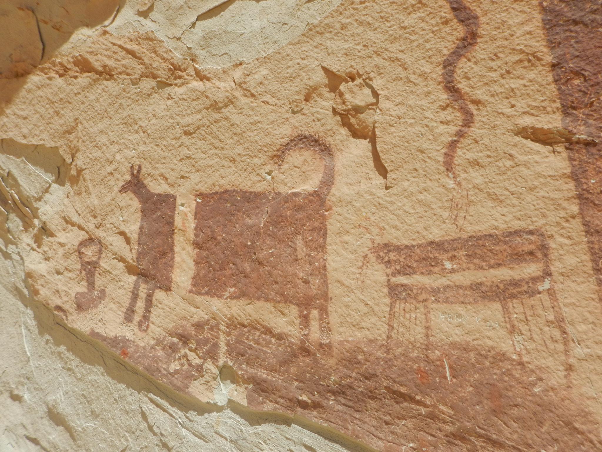
The Temple Mountain Pictograph panel is significant because it contains some of the largest prehistoric painted figures in Utah. The largest image is, at present, about 6 feet tall. It could easily have been 8 feet or more. If you look carefully you will see the backs of two large animals. The sizes of these images seem to suggest that the creators wanted them to be easily seen and to demonstrate that they were of exceptional significance.
It is obvious that a large part of the panel has broken off from the cliff face. This is spalling and it occurs principally because salt crystals grow from mineral-laden water that has penetrated into the stone from above. As the water evaporates near the surface, the crystals grow larger and eventually fracture off the front layer of sandstone.
The presence of several small fragments of pigment in the spalled area between the left side and right side of the panel indicate that the area between them was apparently filled with petroglyphs. The section on the right side of the red figures, where there are streaks of mud, also contains more images. These images are covered over with streaks of mud. When wind blows rain against the cliff face, some of the mud is washed away and the images become more visible; when the rain comes from above, the images are covered with streaks of mud. In total the panel would have been over 100 feet long.
There are two ages of petroglyphs present in this panel. The horned figure on the far left is a Fremont anthropomorphic stylized human figure. The concentric circles are a common element in Fremont Panels. The Fremont existed from about AD 100 to AD 1300 and lived in nearly all of Utah. The other figures are Barrier Canyon Style which have several proposed dates. Some people believe that they date to the Archaic period, which started about 8000 BC and ended about 2000 years ago, others believe that they date to AD 1 to 1100. Other dates have been proposed and there is even some disagreement on what actually constitutes Barrier Canyon Style.
The Fremont figures are placed far to the left because it is likely that the rest of the cliff face was covered with Barrier Canyon Style figures. Why do you think the Fremont placed their pictographs on this panel?
Getting There
Reach the trailhead by going west from Green River Utah on I-70 to the junction with highway 24 that goes to Hanksville. Go toward Hanksville for about 25 miles to Mile Post 135.
Route Description
Rock art and historic sites are fragile, non-renewable cultural resources that, once damaged, can never be replaced. To ensure they are protected, please:
- Avoid Touching the Petroglyphs: Look and observe, BUT DO NOT TOUCH!
- Stay on the Trails: Stay on the most used trails when visiting sites, and don't create new trails or trample vegetation.
- Photography and Sketching is Allowed: Do not introduce any foreign substance to enhance the carved and pecked images for photographic or drawing purposes. Altering, defacing, or damaging the petroglyphs is against the law -- even if the damage is unintentional.
- Pets: Keep pets on a leash and clean up after them.
- Artifacts: If you happen to come across sherds (broken pottery) or lithics (flakes of stone tools), leave them where you see them. Once they are moved or removed, a piece of the past is forever lost.
The initial panel is visible from the road, but small and a bit hard to spot. It is on a vertical section of rock BEFORE reaching the first large campground on the left (south) side of the road. Less than 2 minutes from the fence, park anywhere on the edge of the road.
The main panel is on the right, where several roads go off to an old drill hole. There is a campsite here, however, please refrain from camping at the panel so others can visit without having to traipse through someone's camp. From the drill hole, the panel is big and clearly visible 15 or so feet above the ground. A thin ledge allows for an up close look, but is exposed. Please do not touch or otherwise damage the panels.
Maps

12S 529743E 4278775N
38°39'25"N 110°39'29"W
12S 528799E 4279210N
38°39'40"N 110°40'08"W