Peak 8235 | Torrey

Hiking Peak 8235 - Torrey Hiking Peak 8235

Torrey

Overview

RATING: Easy / Moderate Hike

Tue

Patchy smoke and a chance of showers and thunderstorms after noon. Mostly sunny. High near 83, with temperatures falling to around 77 in the afternoon. West southwest wind 9 to 14 mph. Chance of precipitation is 50%.

83 | 65

Wed

A chance of showers and thunderstorms between noon and 3pm, then a chance of showers and thunderstorms. Sunny, with a high near 81. West wind 14 to 22 mph. Chance of precipitation is 30%.

81 | 62

Thu

A slight chance of showers and thunderstorms after noon. Mostly sunny, with a high near 78.

78 | 59

Fri

A chance of showers and thunderstorms. Partly sunny, with a high near 76.

76 | 61

Sat

A chance of showers and thunderstorms after noon. Mostly sunny, with a high near 76.

76 | 58

View Full Weather Details
SEASON: Fall, Spring (Hot in the summer)
GEAR: Standard Hiking Gear
WATER: None, bring all you need.

Tue

Patchy smoke and a chance of showers and thunderstorms after noon. Mostly sunny. High near 83, with temperatures falling to around 77 in the afternoon. West southwest wind 9 to 14 mph. Chance of precipitation is 50%.

83 | 65

Wed

A chance of showers and thunderstorms between noon and 3pm, then a chance of showers and thunderstorms. Sunny, with a high near 81. West wind 14 to 22 mph. Chance of precipitation is 30%.

81 | 62

Thu

A slight chance of showers and thunderstorms after noon. Mostly sunny, with a high near 78.

78 | 59

Fri

A chance of showers and thunderstorms. Partly sunny, with a high near 76.

76 | 61

Sat

A chance of showers and thunderstorms after noon. Mostly sunny, with a high near 76.

76 | 58

View Full Weather Details
The Henry Mountains and Capitol Reef from the summit.

The Henry Mountains and Capitol Reef from the summit.

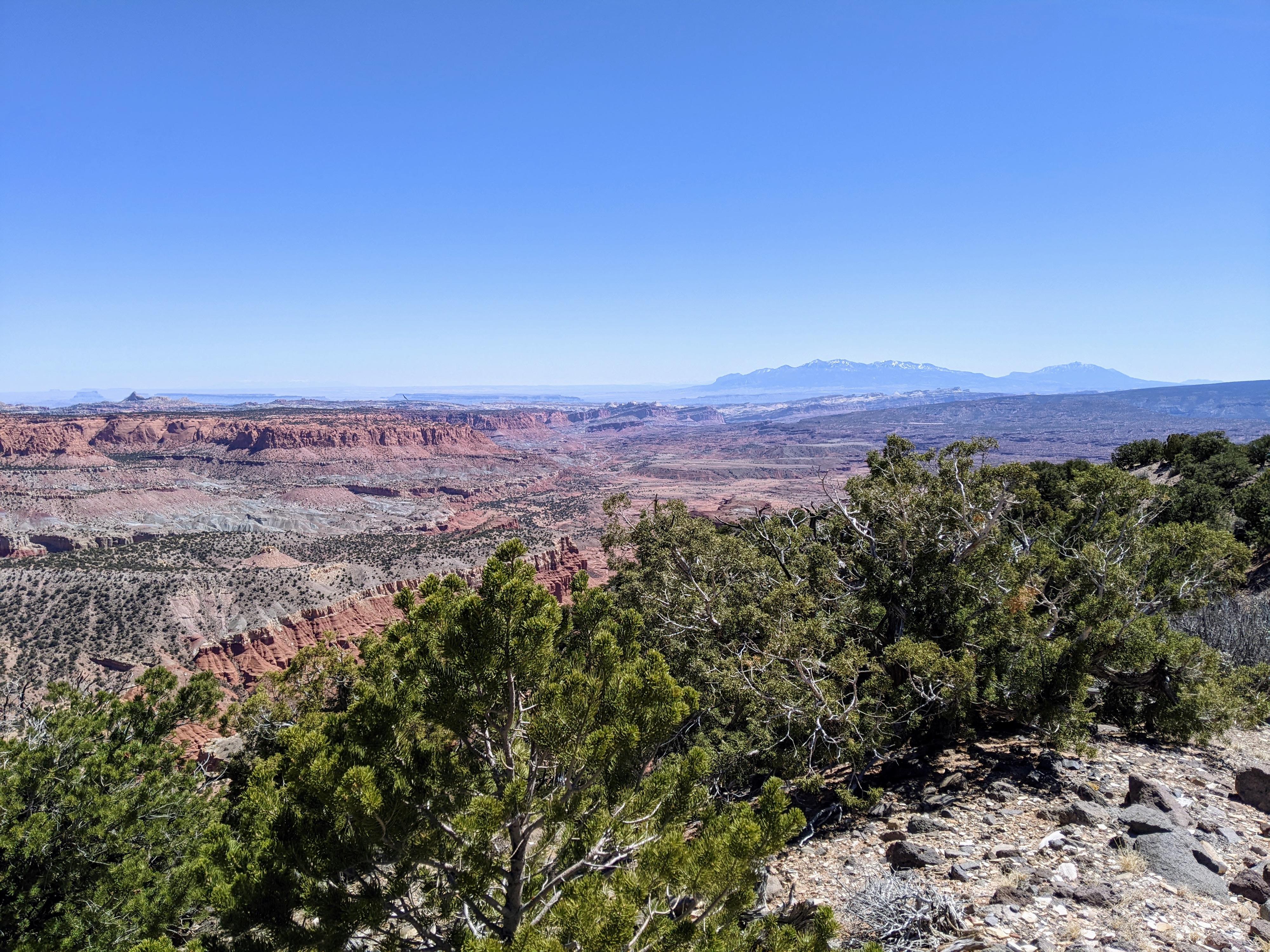
When visiting the Capitol Reef area with a dog, it can be a challenge to find scenic hikes outside of the park. Abby “Wonder Dog” McGee and I decided to visit unnamed peak 8,235’ north of town. This out of the way hike has great red rock views and is outside of the park. The hike follows an old exploratory drill road for most of the route and ends with views of Capitol Reef. It turned out to be a great out-of-the-way outing.

Note: The hike is dog friendly except a couple of short sections of cactus covered flats where dogs will need to be carried briefly or find a circuitous route around the obstacles. Experienced desert dogs should be fine, but less experienced dogs may struggle with cactus. Tweezers recommended if bringing a less experienced dog in case they get a cactus.
Trailhead Note: The hardest part of this adventure is reaching the trailhead. The road requires true high clearance 4-wheel drive. There is one spot, in particular, that requires a narrow passage between a boulder and wash bank. Much of the rest of the road is quite rocky and rough.

I have had a Grand Cherokee and Ford Ranger to the trailhead without issue, but suspect a full-size truck or lower clearance 4x4 would be fairly difficult to get to the trailhead. This is part of the Great Western Trail, and ATVs would be a great option for reaching the trailhead if available.
The view west from the summit. The Ant Hill is the prominent summit on the right.

The view west from the summit. The Ant Hill is the prominent summit on the right.

Getting There

From the west side of the town of Torrey.

  • Turn north on Sand Creek Road and reset your odometer. ( 12S 462189E 4239096N / 38°17'57"N 111°25'57"W )
  • 0.7 miles - Turn left onto Forest Road 146. ( 12S 462196E 4240272N / 38°18'35"N 111°25'57"W )
  • 1.5 miles - After a rough wash crossing, the road splits. Go right. ( 12S 461319E 4241237N / 38°19'06"N 111°26'33"W )
  • 2.3 miles - Junction, stay right toward Sulphur Basin. ( 12S 461494E 4242311N / 38°19'41"N 111°26'26"W )
  • 2.4 miles - Junction on a bend. Go left. The road gets rougher the farther you go. Stay on the obvious main road as it follows near the wash, crosses, then climbs to the mesa above. ( 12S 461590E 4242356N / 38°19'43"N 111°26'22"W )
  • 5.5 miles - Road bends to the left after reaching the hill top. This bend is the trailhead. ( 12S 461505E 4245945N / 38°21'39"N 111°26'26"W )
Abby heading over to the final climb up the peak across the narrow neck of land.

Abby heading over to the final climb up the peak across the narrow neck of land.

Route

From the trailhead, follow the old, very rocky road as it heads southeast. This now impassable road appears to have been used for drilling exploratory wells in the area. It makes for easy walking and route finding. Follow the old road. It heads east, then curves and heads south. At about 1.4 miles (30-ish minutes) from the trailhead, an old drill hole is visible just off the left (east) side of the road. Continue on the main old track. It is generally easy to follow, though becoming less visible with time in spots.

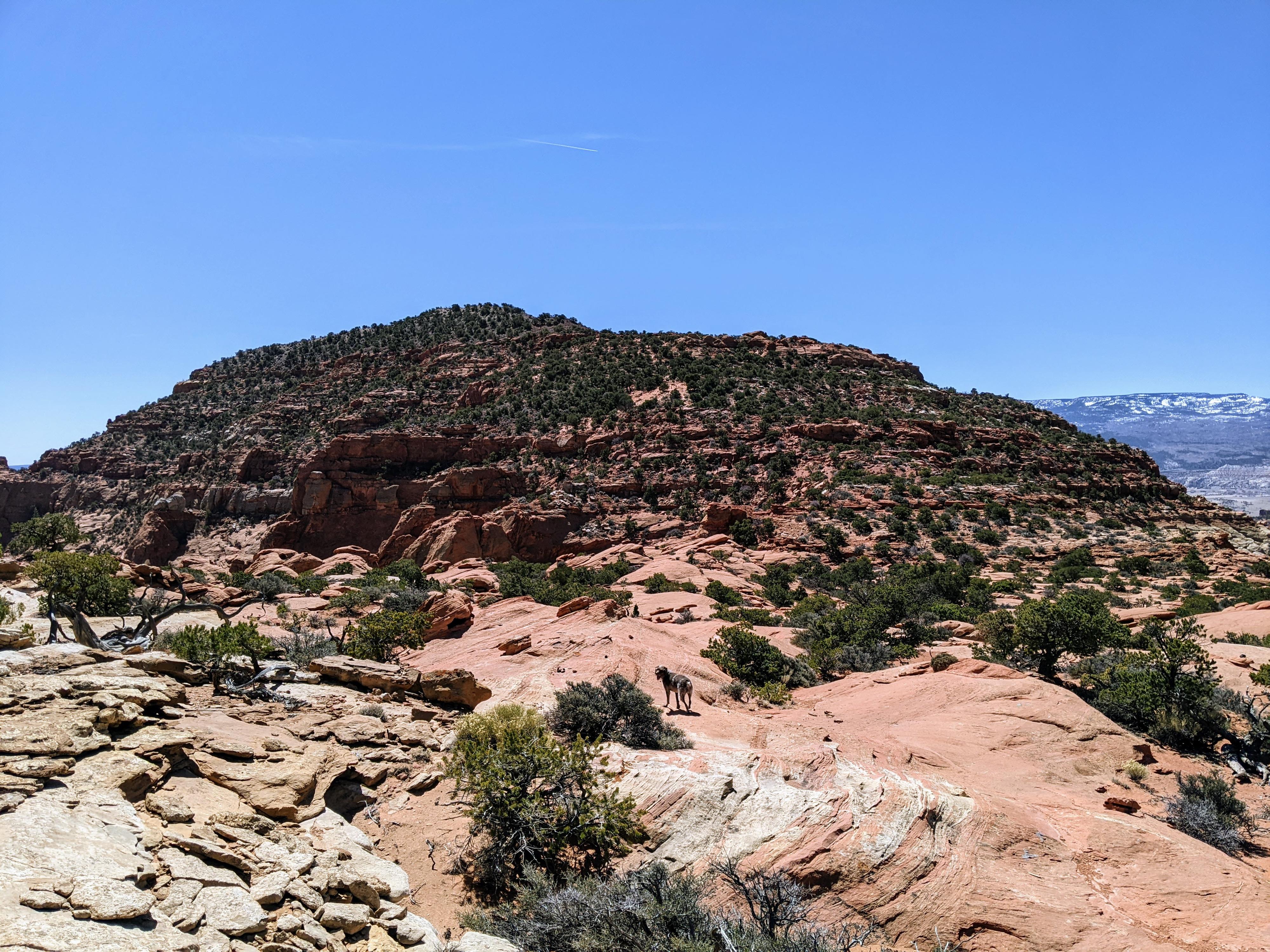
About 1.85 miles, the track becomes faint and turns due east. Where it turns east, you can see the narrow neck of land separating the larger part you have been hiking on, with peak 8,235 to the south. Leave the track wherever is convenient and begin heading directly for the peak.

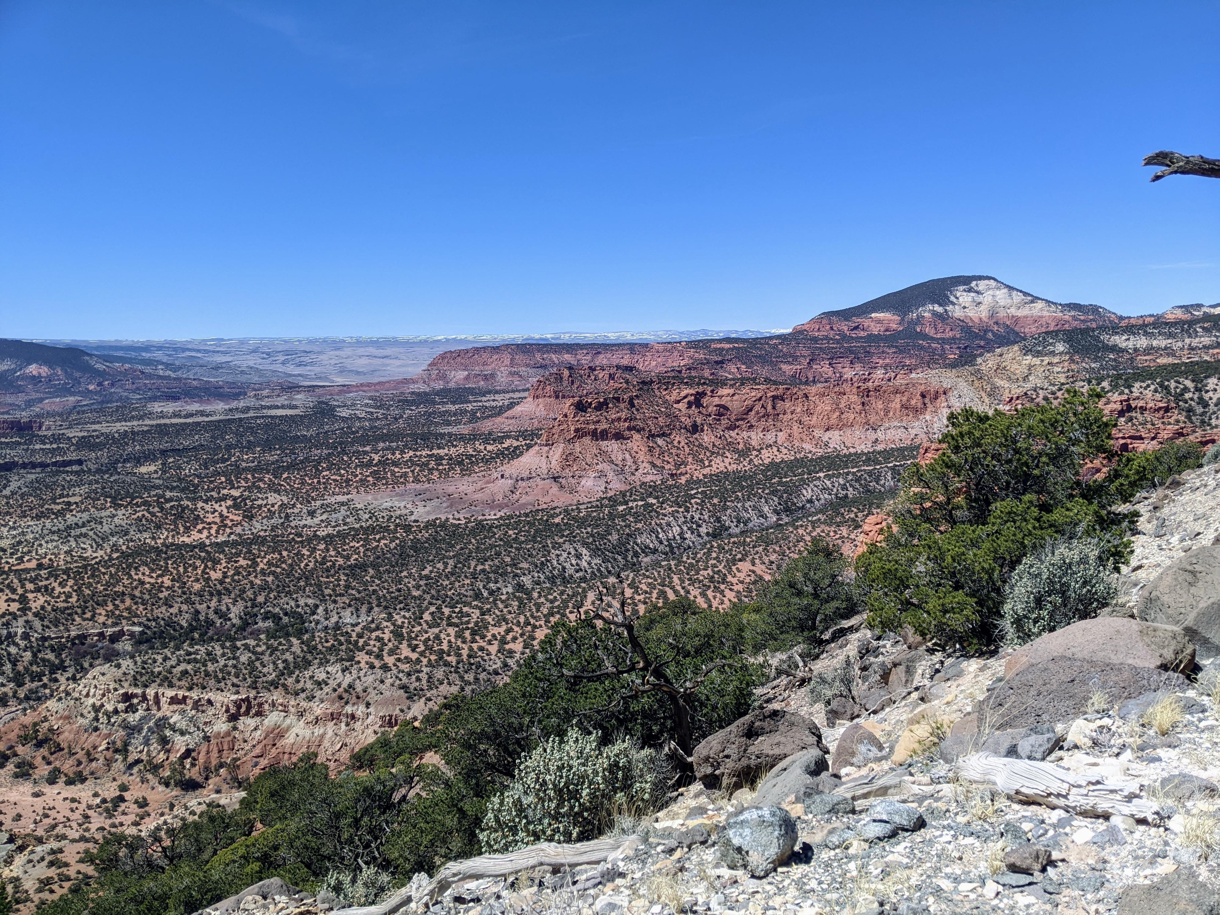
Side Trip: The track continues east for just a minute or two through a cactus patch and ends at an amazing view of Capitol Reef to the east. It is well worth the short side trip, but beware of cacti if travelling with dogs.

Cactus Warning: From leaving the old track and heading south, the major cactus patch that may give dogs trouble is encountered. Staying more south east seems best, but be careful of cactus if you have dogs along.

Cross the land between the mesa and peak, then work your way up the peak. There are many options. The track shown on the map had a few cairns and very faint old foot prints. Good route finding makes reaching the summit easy with no exposure or major difficulties. The summit has excellent views of Capitol Reef to the east, Boulder Mountain to the south, and Thousand Lake Mountain to the north.

Return the same way.


Maps

Route / 5.70 miles / Elevation Range 7,746 - 8,176 ft.
Printable Maps:

Trailhead

12S 461504E 4245936N

38°21'39"N 111°26'26"W

Well Pipe

12S 462621E 4244709N

38°20'59"N 111°25'40"W

Overlook

12S 462870E 4244116N

38°20'40"N 111°25'30"W

Route Up

12S 462667E 4243667N

38°20'25"N 111°25'38"W

Summit

12S 462859E 4243277N

38°20'13"N 111°25'30"W

Leave Track

12S 462740E 4244114N

38°20'40"N 111°25'35"W

Comments

Want to make a comment? Login and let yourself be heard.