
 Lower Comb Wash
Comb Ridge
Overview
Lower Comb Wash is a place with immense history. The spot is at the junction of Comb Ridge and the San Juan River, a natural spot that funnels traffic in the area through a small region.
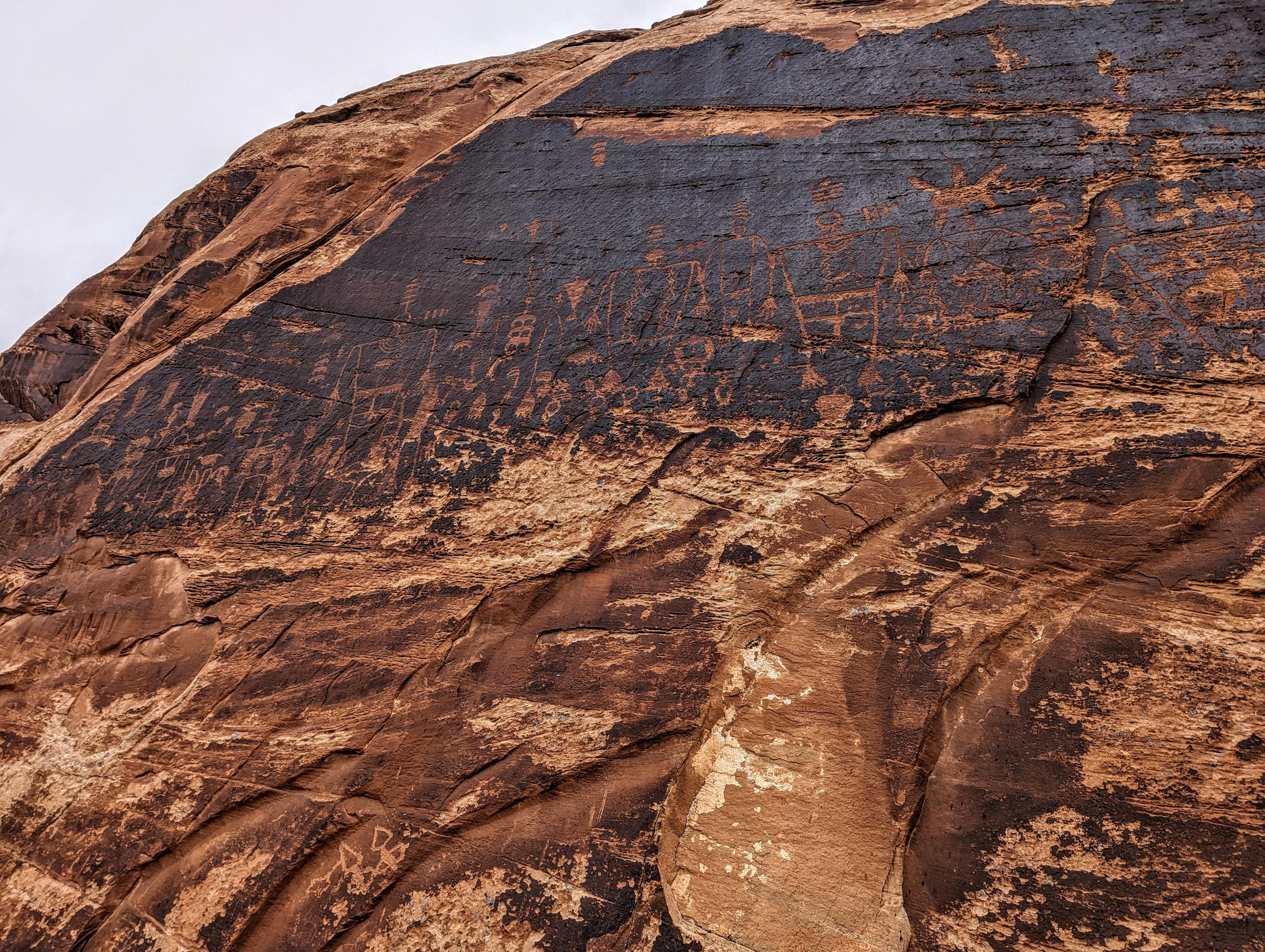
Native American lived and likely grew crops on the fertile banks of the San Juan. River House Ruin, tucked into an alcove on the south end of Comb Ridge, is one of the most impressive ruins in the region and fascinating to visit. East of River House Ruin, the cliffs have numerous petroglyph panels, including the famous Kachina Panel. The Kachina Panel is often considered one of the largest and most impressive panels in the area.
After the Native Americans, the Mormon Pioneers passed through the region in the late 1870s and early 1880s. When their legendary expedition reached Lower Comb Wash in the spring of 1880, Comb Ridge was the last major obstacle they needed to overcome to reach their destination near modern-day Bluff. They crossed Comb Ridge by building a route up and over that was so difficult, many horses were left battered and bloody from the effort to get wagons across. They named the area San Juan Hill, which is just a bit west of River House Ruin. After the pioneers, a trading post was built that became known as Barton's Trading Post after changing hands a few times. It was short-lived, but some relics of its history remain.
Today, the area is very frequently visited by those floating the San Juan River, as well as hikers and tour groups.
Getting There
Reaching the area starts by turning south off US-163 at milepost 38.3. This is a little over 10 miles west of Bluff. Once you turn off the highway, reset your odometer. The road will split and have many side roads. Stay on the most used and best-looking road that goes down Comb Wash. The map shows the path of the road when I drove it, but it may change with floods and use. In general, you will be either near the bottom of Comb Wash or to the east (left) side of it.
At 3.85 miles, the road will have climbed out of Comb Wash and be up on a hill as it nears the bottom of Comb Ridge. A junction in reached here. Go left. The road will begin to curve and head east now.
4.1 miles - Junction with a spur road on the left that goes to San Juan Hill.
4.25 miles - Junction. Go right and right again in just a couple of hundred feet to get to Barton's Trading Post. From the old trading post, continue on the road as it heads east and descends to the San Juan River floodplain. This descent can be rough. Check it before committing.
4.8 miles - A wide spot on the left and River House Ruin Trailhead. The ruin is visible from the trailhead.
From River House Ruin, there are several small rock art sites along the road on the cliff band. Keep a sharp eye out. The road also passes through private property during the next section. It is currently (2024) not signed "no trespassing", but don't camp or hike off the road during this section.
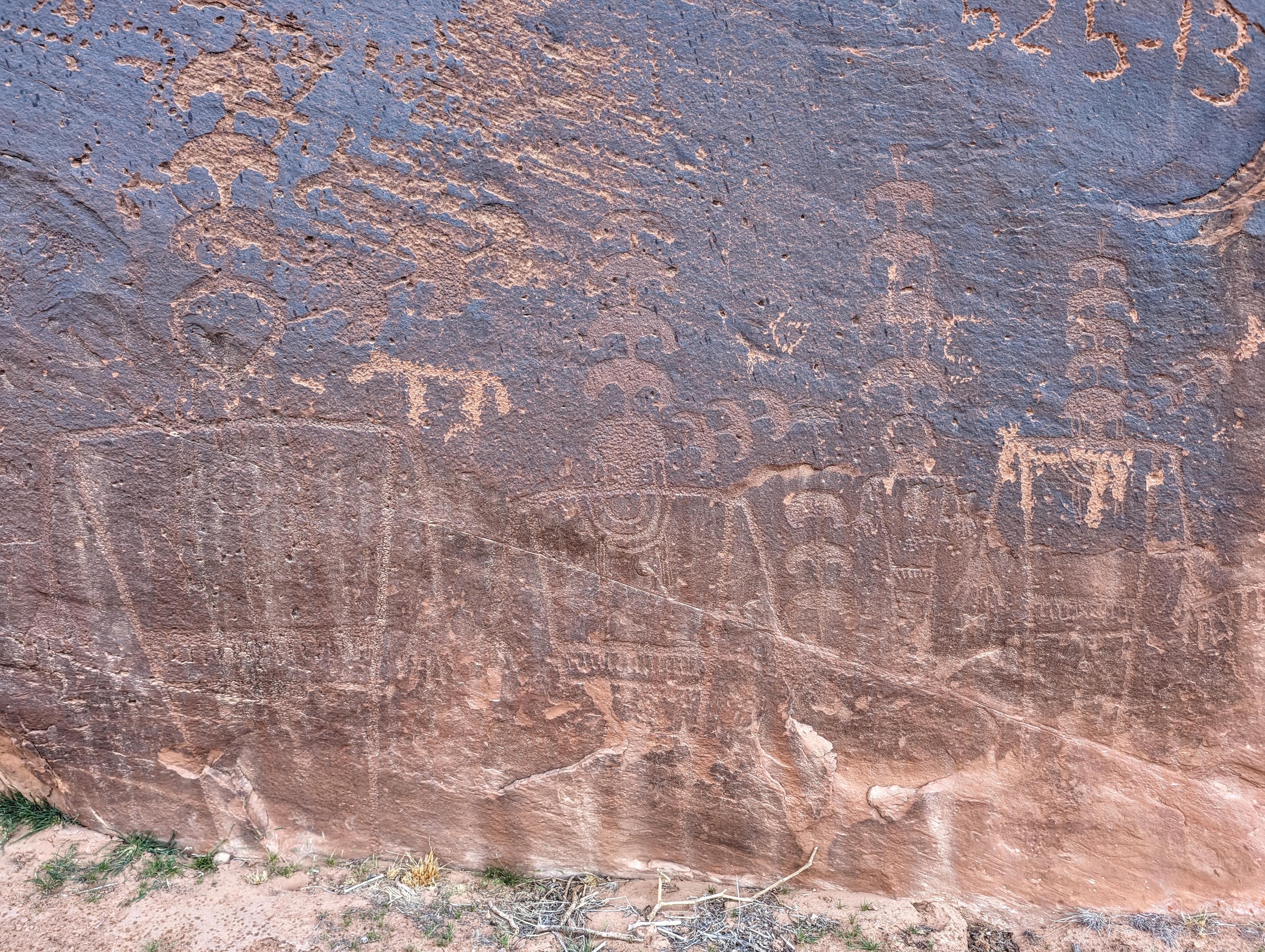
5.5 miles - The road comes close to the cliff. This area is known as Joe's Corral. If you look closely, there are rock art panels here, though some are a bit difficult to see. Just beyond, the road gets quick narrow from brush. You may want to walk from Joe's Corral, particularly if in a full size vehicle.
6.1 miles - Park here before the road climbs a bit and deteriorates. This is the Kachina Panel trailhead.
Route Description
San Juan Hill
The side road for San Juan Hill leads a short distance to a fence and information sign. The trail, leading up Comb Ridge behind the fence, is not nearly as well-defined as I expected, but with a close eye, can be followed up. There are occasional historic trail markers along the way as well. We followed it up about 0.4 mile, then stepped off the old trail to the west for nice views. En route there is a short side trail and marker and what, I assume, is an original pioneer inscription: We Thank Thee O God.
The Rincone
The Rincone, aka Barton's Trading Post, is right next the road past San Juan Hill. From the information sign at the site:
Early one morning in June 1887, two Navajos came into the store and began arguing with Barton. In the heated confrontation that followed, one of the Navajo s pulled a gun and accidentally killed his companion and fatally wounded Amasa Barton. Tense hours and days followed the shooting for it was feared that it could lead to a major confrontation. Through the diplomacy of the settlers in Bluff and Navajo leaders, further bloodshed was prevented.
Following the Bartons, cowboys of the Elk Mountain Cattle Company moved in, making this the center of their operation throughout the late 1880s. Today the walls of the milk house and the platform for the water well (east of here) are all that remain of the trading post.
-Hole-in-the-Rock Association."
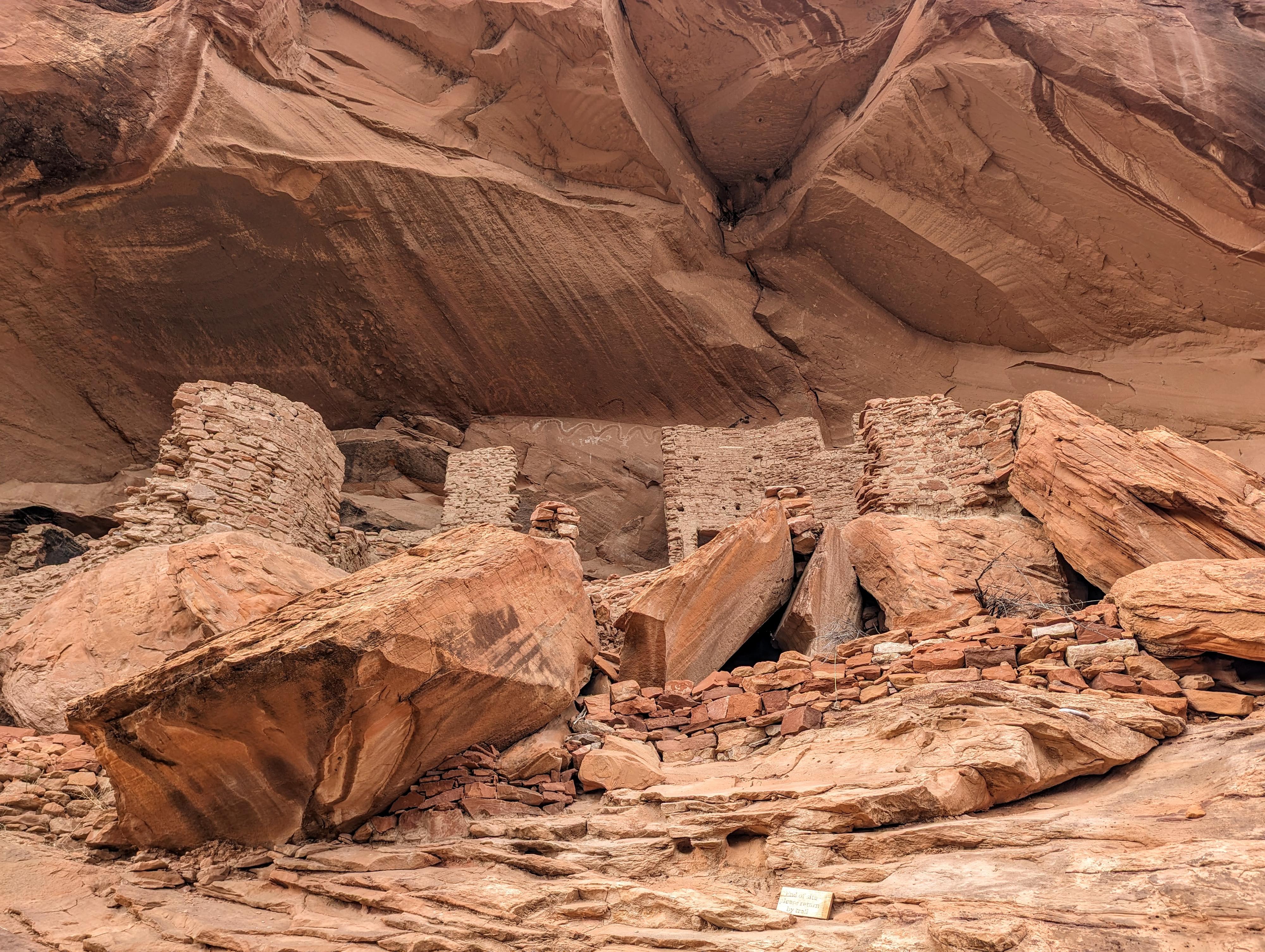
River House Ruin
Probably the main attraction for most, River House Ruin is one of the largest ruins in the area. When visiting, follow the short trail to the ruin, but also follow the base of the cliffband west a bit as there are rock art panels and another small ruin a short distance from the main River House Ruin
The exact purpose of the River House Ruin remains a subject of scholarly debate, but it is thought to have served as a residential complex, possibly housing several families. Its strategic location near the San Juan River suggests that the inhabitants may have relied on agriculture, fishing, and trade for sustenance and livelihood.
Joe's Corral
Joe's Corral, the next major site, is on the left, where the road comes close to the cliff. The site is visible from the road, or a short stroll to see the panels up close. They are of a similar style to Kachina Panel, though it is a small site in comparison.
Kachina Panel
From the parking area, follow the social trail as it heads up along the San Juan. It passes a large informational sign and a spot where rafters often stop and tie up their boats to visit the panel. The trail then heads up to the base of the cliff and the panel, which extends east along the cliff for a fair distance.
One of the largest and most ornate panels in the area, Kachina Panel is extraordinary. The number, size, and detail of the panels are really breathtaking. Return the way you came after visiting.
Photos
Maps
")
")
12S 617546E 4125229N
37°15'58"N 109°40'27"W
12S 615162E 4120231N
37°13'17"N 109°42'07"W
12S 615442E 4120117N
37°13'14"N 109°41'56"W
12S 615557E 4120296N
37°13'19"N 109°41'51"W
12S 615567E 4120748N
37°13'34"N 109°41'50"W
12S 615658E 4120159N
37°13'15"N 109°41'47"W
12S 615799E 4120033N
37°13'11"N 109°41'41"W
12S 616411E 4120390N
37°13'22"N 109°41'16"W
12S 616390E 4120420N
37°13'23"N 109°41'17"W
12S 616514E 4120466N
37°13'24"N 109°41'12"W
12S 617213E 4120869N
37°13'37"N 109°40'43"W
12S 617825E 4121474N
37°13'56"N 109°40'18"W
12S 617991E 4121596N
37°14'00"N 109°40'11"W