 Hiking
Moonhouse Ruin (McCloyd Canyon)
Hiking
Moonhouse Ruin (McCloyd Canyon)
Cedar Mesa
Overview
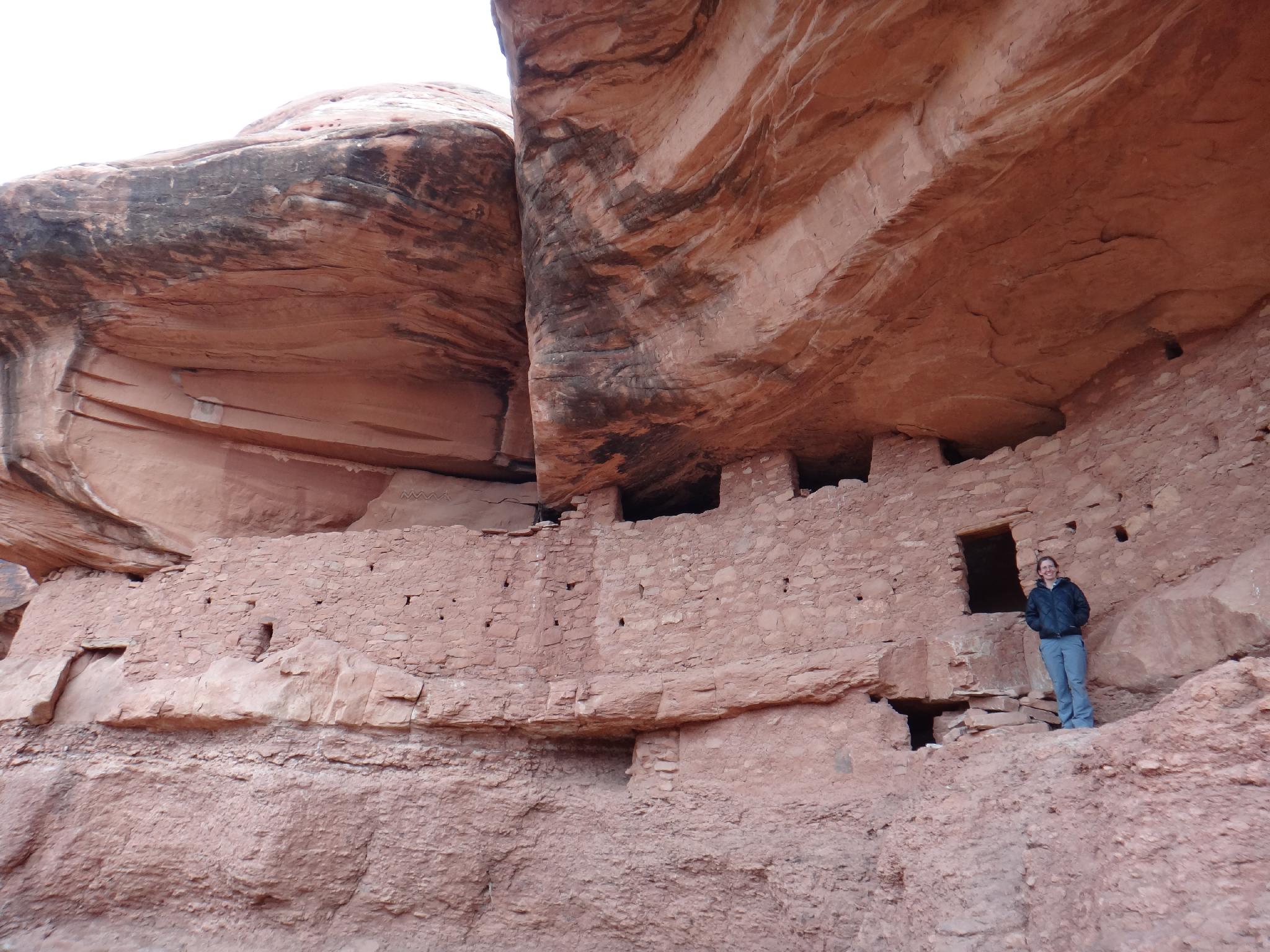
Moonhouse, in my opinion, is one of the most interesting ruins that is easy to visit on Cedar Mesa. It is estimated to have been constructed about 800 years ago, with a unique design. The ruins namesake room, Moon House, is a room with the moon painted on opposite walls. Access is easy via a relatively short, but stunning hike. The trail descends from the mesa, crosses the canyon, and visits Moon House proper, as well as several other ruins, granaries, and a kiva in the area. Moon House Ruin is one not to be missed in my opinion.
I first visited Moonhouse Ruin in the mid-1990's, and visited several times in the following years. It is a very magical place, and I have been reluctant to share information about it. With the internet, however, the secret has gotten out to the point that visiting Moonhouse Ruin now requires a permit and is limited to 20 people a day. Oh, how times change!
The current permit system limits use to 20 people per day during the high season (March 1st - June 15th, and September 1st - October 31st). During these times, permits may be reserved in advance by calling the ranger station. 12 of the 20 permits are reserved ahead of time, 8 are left available for walk-ins. The current fee is $2 per person. Being one who despises permits, I strongly recommend visiting in the off season when permits are required, but there is no limit, and they are gotten via a self-pay envelope at the trailhead. Many of my visits have been in December, which can be perfect if the roads are dry and passable. Summer is also do-able with an early start.
Current permit information is available on the BLM website.
Grumbling about the permit system aside, I was very surprised to visit Thanksgiving weekend 2014 and not see anyone else the entire day. The register showed a few groups on weekends, but generally not more than 1-2 groups on any given weekend and often weekdays there was no visitation. Clearly the offseason is the time to visit if you want to experience the magic of the area without other visitors.
Though it can be visited in an hour or two, I would recommend planning on most of the day. The ruins offer lots to see, and I am surprised to discover something I had not seen before on every trip. There are moki steps, ruins, rock art, and even a baby's foot imprint on the mud of one of the more out the way ruins. Bring a camera and plan on a relaxing day taking in the sights.
Getting There
The trailhead is reached off of highway 261, which runs from near Natural Bridges (highway 95) south to near Mexican Hat. From Blanding, go south out of town a couple of miles and turn west onto Highway 95. Follow it about 28 miles to the junction with 261 and head south.
At milepost 22.6 (about 9.5 miles south of the highway 95/261 junction), a signed Snow Flat Road that goes off to the east.
Route Description
Rock art and historic sites are fragile, non-renewable cultural resources that, once damaged, can never be replaced. To ensure they are protected, please:
- Avoid Touching the Petroglyphs: Look and observe, BUT DO NOT TOUCH!
- Stay on the Trails: Stay on the most used trails when visiting sites, and don't create new trails or trample vegetation.
- Photography and Sketching is Allowed: Do not introduce any foreign substance to enhance the carved and pecked images for photographic or drawing purposes. Altering, defacing, or damaging the petroglyphs is against the law -- even if the damage is unintentional.
- Pets: Keep pets on a leash and clean up after them.
- Artifacts: If you happen to come across sherds (broken pottery) or lithics (flakes of stone tools), leave them where you see them. Once they are moved or removed, a piece of the past is forever lost.
From the trailhead, follow the obvious trail north. It is well cairned and reaches the rim of McCloyd Canyon in a few short minutes. The cairns lead a winding path down the slick rock to a step off ledge with a pile of rocks. The ruins are visible across the canyon at this point. Follow the trail as it meanders down to the canyon floor and ascends the other side to Moon House Ruin proper.
From Moonhouse, stay at that level, and follow social trails up the canyon to a small ruin and a kiva. There are more small ruins up the canyon, but many will be stopped by a couple of small dryfalls before then.
Staying at the Moon House level and heading down canyon leads to several other impressive ruins before the ledge becomes impassably narrow. (There are great moki steps at the end of the ledge that were used as a way out of the canyon.)
From the BLM:
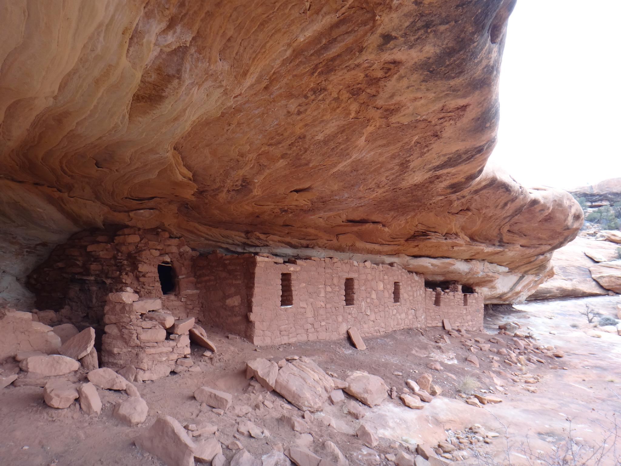
Welcome to Moonhouse. This Anasazi ruin consists of three cliff dwellings spread out along one quarter mile of the canyon. With a total of 49 rooms, it is one of the largest prehistoric dwellings on Cedar Mesa. It is also one of the most fragile.
We ask you to make your visit to this fragile ruin as low impact as possible. Please do not enter any of the rooms; don't lean, climb, or pull on the wall; and avoid touching rock art and plaster. Please leave all artifacts where you find them for others to enjoy.
The Cedar Mesa area is influenced by two branches of prehistoric puebloan people, the Mesa Verde people to the east, and the Kayenta people to the south. The influence of both can be seen in the architecture and pottery found throughout the area.
If you look closely you will notice several different types of room construction. Face the ruin and look at the unroofed structure to your right and also the buildings on the shelf in the back of it. Notice the difference between these buildings and the structure on the far left side of the shelf.
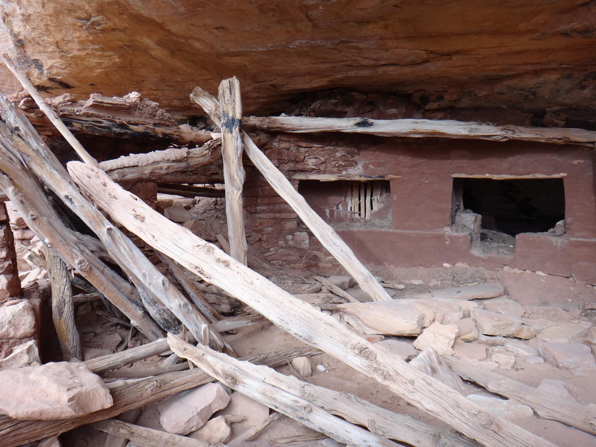
The walls, and in some cases entire buildings are constructed of poles and mud. This is called jacal (pronounced ha-kal) construction. Vertical poles are put in place, then smaller poles are places horizontally and tied together with willow or yucca strips. Sometimes mud is packed on both sides, and in other cases only part of the wall is covered in mud. Juniper, willow, oak, and cottonwood were used in construction of jacal walls at Moonhouse. These buildings are some of the earliest standing structures build here.
Now look at the long wall that composes the main part of the cliff dwelling. This wall was constructed of irregularly shaped blocks set in place with the flat surface to the outer and inner wall. The blocks are generally well spaced and uniform in size. You will also notice small stones placed between the blocks. This is called chinking and it fills space between the blocks. As you wander around the dwellings, notice how chinking takes on a decorative quality on many of the buildings. These buildings are the later structures of Moonhouse.
Notice the series of small holes in the long wall. They are called loop holes. There are 27 loop holes in the wall here at Moonhouse. These holes provided line of sight coverage of all angles of canyon access, the main ledge in front of the ruin, and part of the canyon bottom. Loop holes are common features in many late period (late 1200's) structures on Cedar Mesa and many other areas on the northern Colorado Plateau. Further research may help us answer the question about the function of loop holes.
As you walk around the site you will notice remnants of mud along the back walls of the rock shelter. Archeologists call these 'ghost walls'. They are the remains of former structure, the materials of which were probably reused in construction of some of the buildings you see today.
At Moonhouse, Pinyon and Juniper logs are common building materials for ceiling beams and uprights. These logs are ideal subjects for the science of tree ring dating called dendrochronology, an excellent method for determining site occupation. In 1974, 192 tree ring core samples were taken from Moonhouse and 134 dates were obtained. These dates indicate a forty-two year span of beam cutting between 1226 and 1268 AD. During these years there were three peak building periods: 1242-1244 AD, 1249-1254 AD, and 1256-1265 AD. Evidence suggests that some beams were stockpiled for later use and that others were reused over time.
You will notice several pictographs (painted rock art) either on or near the structures. The solid white band with triangles and dotes is a symbol that is depicted at other location in the areas. This symbol is also painted on one of the jacal walls at the ruin. This helps us to date the painting. Since tree ring dates from the room suggest it was build around 1264 AD, we can assume a date for the painting. Rock are and other evidence near Moonhouse suggests that there was also an earlier Basketmaker (0-500 A.D.) occupation of the canyon area.
Cedar Mesa has probably always been a marginal environment for agriculture. With the limited estimated annual rainfall of 12-13 inches, any dry year could be devastating. During the late 1200's many of the living (habitation) areas at Moonhouse were converted to storage. Archaeologists estimate that there was a conversion of habitation rooms to storage rooms of five to one. Two theories exist regarding this conversion to storage. First, the people at Moonhouse were storing up enough food to feed other residents of the canyon. Second, storage of surplus food was a buffer against increasingly poor harvests. While both theories are possible, there is evidence of increasing drought conditions in the late 1200's which may have led to abandonment of the mesa between 1270 and 1300.
Archeologist have used several different methods to determine the population of Moonhouse. During the later period of occupation, thirty of the habitation and storage rooms were in use. Based on the number of rooms being used, it is assumed that between 25-35 people lived at Moonhouse. It is not known how many people from the surrounding area may have also used Moonhouse.
The ancestors of the people who lives at Moonhouse did not just disappear, they are alive and well today. The Hopi in Arizona, the Zuni and the Rio Grande Pueblo people in New Mexico have ancestral ties to this area. This is a sacred place to them and it should be treated with respect.
Approximately 1200 people visit this site each year. Your visit is recorded in history when you acquire your hiking permit and sign in at the trail register box. You can also record your personal history by taking photographs, making sketches or writing a personal journal. Enjoy your visit.
Maps
 Hiking Map")
12S 606420E 4143529N
37°25'57"N 109°47'50"W
12S 606683E 4143943N
37°26'10"N 109°47'39"W
12S 606513E 4144142N
37°26'17"N 109°47'46"W
12S 606923E 4143796N
37°26'05"N 109°47'29"W