
 Newfoundland Mountains
Great Salt Lake
Overview
The Newfoundland Mountains are a remote and rugged mountain range located in northwestern Utah, rising abruptly from the salt flats of the Great Salt Lake Desert. These mountains are part of Box Elder County and are largely isolated from other mountain ranges, making them a distinct feature. The remoteness of the area makes it a serious undertaking to visit. To visit requires over 40 miles of dirt roads ranging from good to washboard and rutted just to get to the edge of the range. A medium clearance vehicle is likely enough to get to the range, but all of the side roads I took up into the slopes of the range required high clearance, and true four-wheel drive is strongly recommended. Due to the distance and remoteness, be sure to have plenty of fuel, water, supplies, and a good spare tire. I had cell reception on the west side of the range, but only spotty reception on the east side.
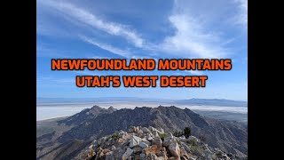
Many visit to hike the highest point in the range, Desert Peak. At 7,005', the peak towers almost 3,000' about the surrounding mud flats. It is a dramatic and unique hike with amazing views. I highly recommend the hike, but I also recommend spending some time checking out the mining ruins in the range. Though some drive out, summit Desert Peak, and drive back in one long day, I would recommend camping at least one night to take in the other sights and see the outstanding sunrises and sunsets in the area. I spent 1 night in the range, and wish I had spent two.
Geology
Geologically, the Newfoundland Mountains are primarily composed of Precambrian and Paleozoic rocks, including limestone, quartzite, and dolomite. These formations date back hundreds of millions of years and have been uplifted by tectonic activity associated with the Basin and Range Province. The range is approximately 30 miles long and 5 to 10 miles wide, with elevations reaching over 7,000 feet. The isolation of the Newfoundland Mountains in the middle of a vast desert basin suggests that they were once islands in the ancient Lake Bonneville, a massive prehistoric lake that covered much of western Utah during the last Ice Age. Shorelines from this lake are still visible on the lower slopes of the mountains.
Mining
Early prospectors began arriving around 1871, and by 1872, the Newfoundland Mining District was officially established. A small settlement known as Knowltonsburg, named after early prospector Chris Knowlton, developed near the area called "the Saddle." This area, on the west side of the range, is known as Miner's Basin today, and the area used to access Desert Peak described below.
Mining efforts steadily grew, and by 1900, ore shipments had begun. The most active mining site was Miner's Basin, where a short-lived town named Boston Terrace was founded. Like many mining camps of the era, it consisted mostly of makeshift housing for workers. By 1905, Boston Terrace mines were featured in the Copper Handbook, highlighting 11 productive claims yielding various minerals such as copper, lead, silver, gold, and more. Though commercial output declined in the early 1900s, small-scale prospecting persisted for decades.
Though most of the mining activity was on the west side of the range at Miner's Basin, Dells Canyon on the east side of the range has the largest and most well-preserved mining ruins today. The Dells Canyon mine had a long tram system, going almost to the ridge of the mountains. Portions of the tram and other mining structures are still in place today. There doesn't seem to be much history available about the mine, apart from the fact that it was probably in the same era as Miner's Basin, and most likely continued at a smaller scale longer than Boston Terrace. Of the mining ruins I visited in the range, this one was by far the most interesting and impressive.
Train and Military Use
In 1904, the Lucin Cutoff was built to reduce the time and distance around the Great Salt Lake. This went, more-or-less, directly from Ogden to Lucin via a 12 mile wood trestle across the Great Salt Lake, then continuing across the flats from modern-day Lakeside. In the 1950's the wood trestle was replaced with an earthen causeway that is still in use today. The access road that follows the train tracks is used today to access the range.
During World War II and the Cold War, nearby areas were used for military testing and training. The bottom edge of the range is closed to public access and is part of the Lakeside Military Area. Some refer to the military area as Area 52 for supposed odd things and sightings that have occurred there. If camping in the Newfoundland Mountains, keep an eye out!
Full Details
To help keep the riff-raff out, and encourage participation, you must login to see the details.
Login For Full DetailsRegistration is free and easy.
Photos
Videos
Newfoundland Mountains - Great Salt Lake