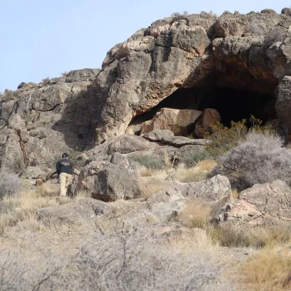
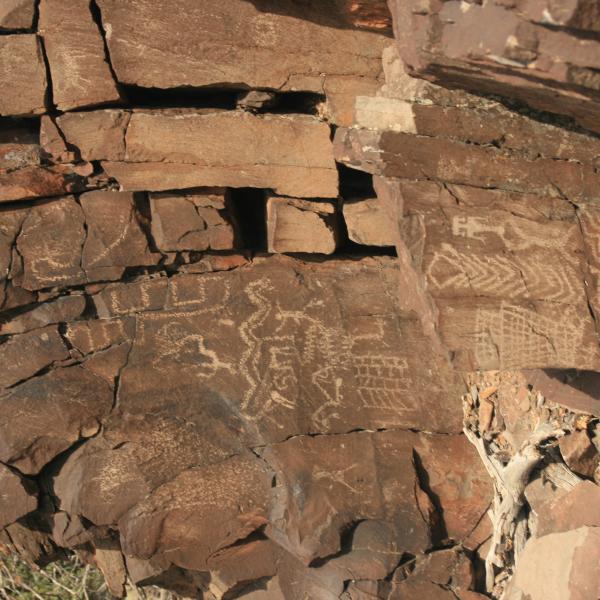
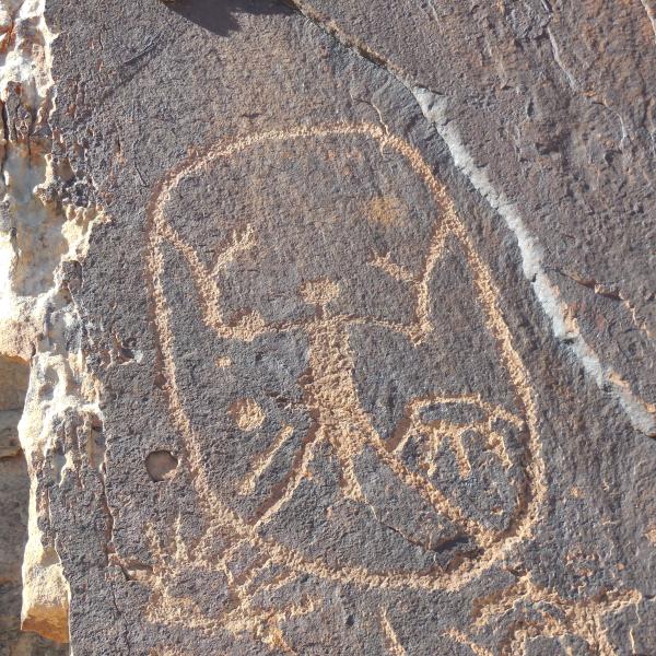
UNKNOWN INDIAN CAVE MORMON MOUNTAINS
Visited a cave that we found last week while exploring the Mormon Mountain Wilderness. There are a great many agave pits in around the area and while looking for one we found this cave.Location: 36°54'45.32"N 114°21'32.71"WThe roads getting there are nice and the climb to the cave is easy.Inside the cave we found some black on grey pottery and the walls are covered in greasy soot. This place has been a habitation site for a long time and has multiple rooms.I cannot find any information on thi......
2022-01-16
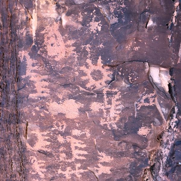
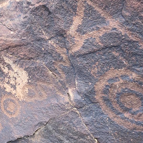
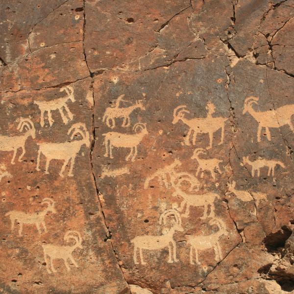
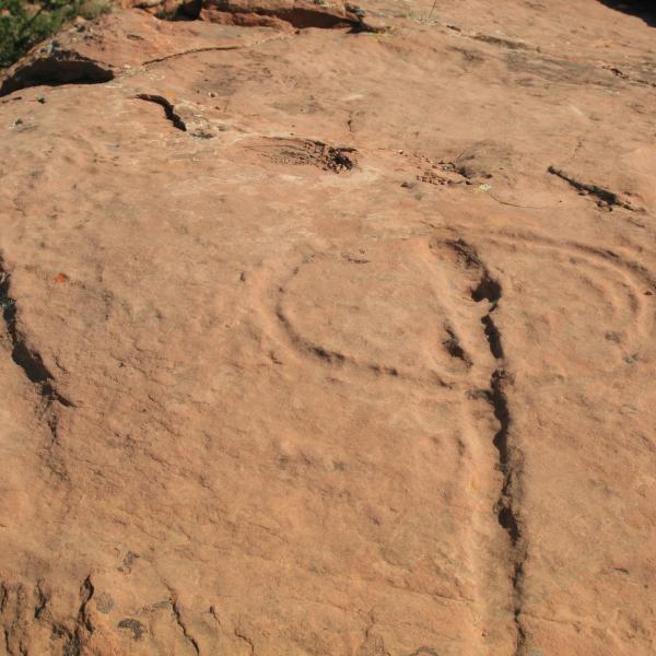
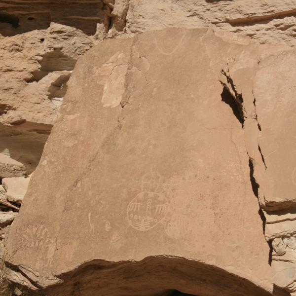
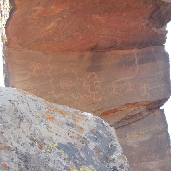
BASKET PETROGLYPH AND RUIN SITE ROSEY CANYON AZ
Finally found this site. The climb up was not fun at all for me but that is the way it is. Lots of real nice art as well as pictures of a lot of baskets. Right off Cane Bed Road regular car can make it.Petroglyphs: N36° 58.142' W112° 52.173'Still looking for Ravens Crack in same area let me know if you have location....
2020-12-05
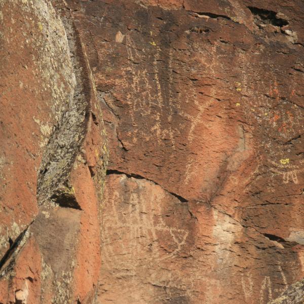
5 PLACES IN ROSY CANYON, UTAH
We went out to find the Basket Site and Ravens Crack locations in Rosy Canyon, Utah but we were unable to find them BUT we found 5 other locations that I have not seen written up anywhere but I am sure someone has visited previously. All are located just off Cane Bed Road.Site 1: 36°58'26.04"N 112°52'6.12"W Small panel short climb from parkingSite 2: 36°57'48.74"N 112°51'57.78"W Big panels with lots of art. We originally thought this was the basket site but the art does not m......
2020-11-30
SOUTH ASH CREEK PETROGLYPHS
Have heard about the panels but could not find them as the directions we received were sketchy to say the least. After some research and just plain driving around we found them. They are in basalt out crop on the North side of South Ash Creek. You can drive with in about .75 miles of the place and hike in. There are no trails so you have to bushwack. Be sure you hike in from the Northern end as it is easier to cross the creek bed. The rocks contain several panels in one area.S. Ash Creek......
2020-11-22
PINE VALLEY PETROGLYPHS
We went to Pine Valley today and located the petroglyphs that are next to the Santa Clara River. You can drive to about 100 yards of the river access trail. Take the trail to the river and follow to the site. The river in this area is really pretty. Some minor bush wacking and rock crawling might be required. We also located a mound area that look like it might have been a location for pit houses. Most of the panels are very faint.Panel 1: 37°24'18.54"N 113°31'36.42"WPanel 2: 37°24'18.......
2020-11-20
GUNLOCK 3 MILE SITE
Visited the three mile site at Gunlock today. This site is 3 miles into the park from the South end. You will come to a cliff wall with a pull out - park there and walk around the cliff to the trail. Once at the top look for foot prints going right and you will find the rock art and probably about a dozen pit houses. The art is scattered all along the rim but there is one news paper rock that is full of art.Art and Pit houses: 37°13'5.88"N 113°46'33.60"WNewspaper Rock: 37°13'5.76"N 113......
2020-11-19
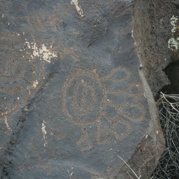
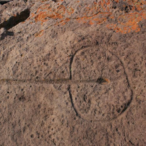
BEST FRIENDS WATERGLYPH
The Best Friends Waterglyph is on the back side of the Best Friends Animal Preserve in Kanab. You can drive a car around back to the parking lot and take a very short hike to the glyph.Waterglyph: 37° 8'47.56"N 112°32'28.94"W...
2020-10-06
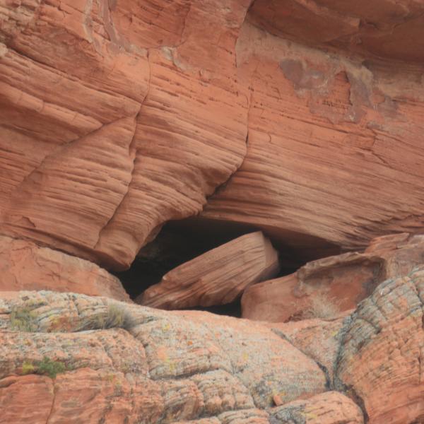
BUCK FARM CANYON WATERGLYPH
Took a long ride to find Buck Farm Canyon Waterglyph on the Northeastern rim of the Grand Canyon. The glyph is on a rock outcrop that sticks out in the canyon from the West. There is a rock shelter under it. Take Hwy 89 out of Jacobs Lake East. Turn South on Forest Road 8910. This road will take you 99% of the way and can be driven in a car. Follow your GPS to the point, there is a parking area there.Waterglyph: 36°23'54.24"N 111°55'4.37"W...
2020-10-06
STUART RANCH ROCK ART AND HUNSTMAN CABIN RUINS
Took a trip today to the Stuart Ranch rock art site which also has the ruins of the Huntsman cabin. The location is North of Glendale Nevada. To get to the site take highway 168 North out of Glendale. Right before the road crosses the railroad you take a right on Meadow Valley Road and follow this for 8.5 miles (all paved). When it turns to dirt go an additional 2 miles until you come to a metal railroad bridge on your left (you are paralleling the railroad). There is also a big sign that......
2020-07-13
RAINBOW CANYON CAVE PETROGLYPHS CEDAR CITY UTAH
Took a short trip to Rainbow Canyon Cave Petroglyphs in Cedar City. The hike is about .75 miles one way and for the most part very easy. After parking just follow the road/trail/wash to your left as it winds around back to the right until you come to the end of the big mountain to your left. If you miss the trail just keep going and eventually you will come to a road and you can follow it back around to the mountain and the trails to the panel. There will be a number of trails up the mountai......
2020-06-28
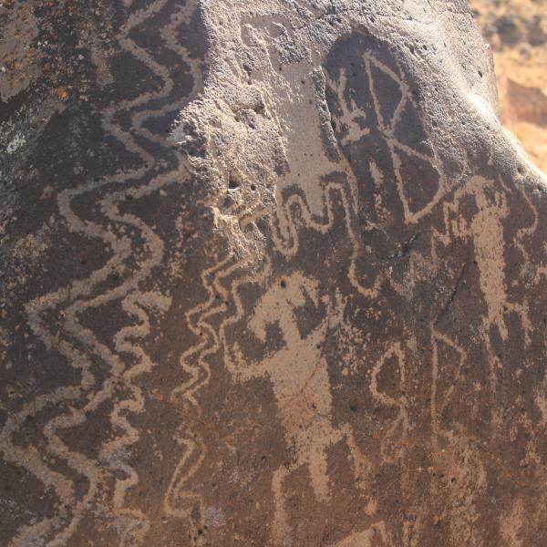
BLACK POINT PETROGLYPHS
Took a trip today South of Parowan Gap to find Black Point Petroglyphs. They are located on the Southern point of the mountain and face Southeast. The art runs along the top of the mesa in the black rock. The climb up is about 50 feet and real easy as there is a pretty good trail. You can access the site from Hwy 130 that intersects I-15 and the road through Parowan Gap. There is a dirt road from 130 that goes straight to the site. I have read where the site is between 4000 and 5000 years......
2020-06-23
SUMMIT PETROGLYPHS
We have heard about these petroglyphs but could not get a good location on them as we all know they are a secret. My wife and I narrowed down where they could be and finally found them. They are located just North of a cinder mine Southeast of Summit, UT. You can park on the left in the mine (it's abandoned) and walk down about 150 yards to the canyon wall. The art is at the top of the wall about a 40' climb that is real easy. You could drive there but someone cut down trees across the road......
2020-06-23
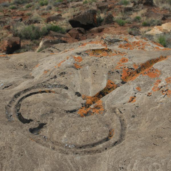
COLORADO CITY WATERGLYPHS
After too many trips to count and too many hikes in the wrong places we finally found the Colorado City Waterglyphs. There are 5 of them in the area right off the highway. You can park near the fence and go through a gate and climb to the top of the knoll. Some of the glyphs are real hard to determine but they are there. Good Luck.CCWG1: N36° 58.058' W112° 58.513'CCWG2: N36° 58.058' W112° 58.513'CCWG3: N36° 57.921' W112° 58.501'CCWG4: N36° 57.921' W112° 58.502'CCWG5: N36° 57.898' W112° 5......
2020-06-07
SHINARUMP CLIFFS WATERGLYPHS KANAB, UT
Located two waterglyphs on Shinarump cliffs in Kanab, UT. The glyphs are in bad shape and are very faint but they are there. Waterglyph 1: 36°59'27.90"N 112°29'48.80"WWaterglyph 2: 36°59'19.27"N 112°29'54.84"WYou can drive to with in 50 yards of these. There is also another petroglyph panel to the east of the first on down the cliff but you have to drive around and climb to see it....
2020-05-09
APPLE VALLEY WATERGLYPHS AND PIT HOUSES
Took a ride today out to Apple Valley to look for two waterglyphs and some pit houses. Found them rather easily. From Hwy 59 in Apple Valley turn right on 400 North (dirt Road) go around curve and stay on this road which is S7400E. Turn right at 37° 1'46.82"N 113° 4'50.84"W or any road that goes to the West towards the mesa edge. At the edge find a road that goes south and park at 37° 0'57.47"N 113° 5'25.24"W. I have not given road coordinates as there are many roads into the area and the......
2020-04-30
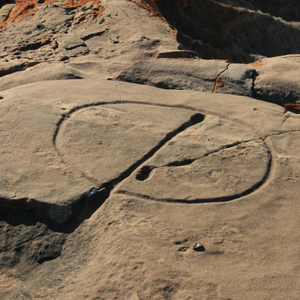
KNOLL SITE WATERGLYPHS
We found the Knoll Site Waterglyph today. There are 5 Panels. Roads into site are real good could probably do in a car but would need high clearance for the ruts. Don't go when raining it will be real muddy. Take Hwy 389 out of Hurricane towards Pipe Springs National Monument. Right before getting to Pipe Springs you will turn right on a well maintained dirt road called Roush road. Follow the way points below to the site. At Parking area we climbed a gate and did a short 1/2 mile hike and a 80......
2020-04-19
TORQUERVILLE PETROGLYPHS
Took a short trip today to find the petroglyphs in Torquerville. They are located at GPS Coordinates 37°17'2.51"N 37°17'2.51"N. You can basically drive up to them. They span about 50 yards and are not in the greatest shape but we wanted to see them. Look at Google Earth to find way in it is all paved....
2020-01-31
NAMING CAVE and PETROGLYPHS
Finally figured out where this place is after getting a run a round from a lot of people. The cave is at GPS Coordinates 37°16'49.32"N 113°50'42.86"W. There area number of ways in there depending upon where you are coming from and what you drive. Look at Google Earth and you will see the routes.Now about the cave. It is supposed to be filled with petroglyphs and I don't doubt that BUT we did not get up in there as I weighed the choice of seeing the petroglyphs or dying and living won out. A fat......
2020-01-31
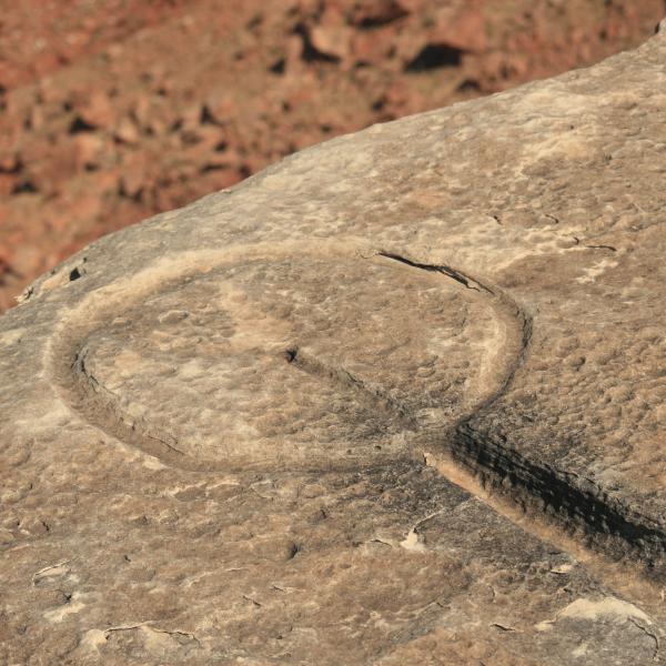
LOST SPRING MESA WATERGLYPH
Took a trip to find another waterglyph, this one on Lost Spring Mesa south of Colorado City, AZ. The drive is about an 70 minutes from the road all dirt, 4x4 required with high clearance. Do not go after bad weather as there are a lot of low spots that will have deep mud in them.Take Hwy 389 out of Colorado City East and turn right on Clayhole Rd (Rd 5). Stay on this road for basically entire trip. About 45-50 minutes later turn left at split. Follow road to the glyph on cliffs edge.There is su......
2020-01-16
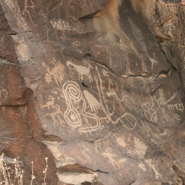
VIRGIN RIVER GORGE PETROGLYPHS - NEWSPAPER ROCK AND DA VINCI MAN
We FINALLY found these panels in the Virgin River Gorge. NO ONE is willing to pass along their location but they are more than willing to show you what THEY have found. I even went to the BLM Office in St. George who said they never heard of the panels. YEAH right! and the check is in the mail. Since we are not the guardians of the past I am sharing their location. The parking lot is just over the first river bridge going from St George to Vegas There is a pull out about 200 yards past the......
2019-12-20
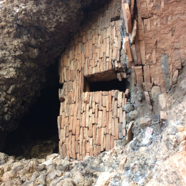
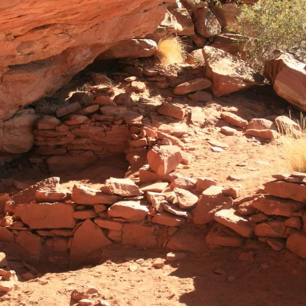
Sycamore Canyon Ruin AZ
Sycamore Ruin just North of Prescott, AZ is a phenomenal ruin in that it sits on a cliff edge overlooking Sycamore Canyon probably 800-900 feet high. The walls are basically intact and so is the roof complete with roof beams. The hike to the ruin from the parking area is short and pretty easy but the scramble up into the ruins is somewhat hairy in that is is loose rock and given how high you are it is a little unnerving.The ruin is located at 34°55'27.22"N 112° 3'48.98"W on the cliff face. Yo......
2019-11-23
Little Creek Mesa Waterglyph - NEW UPDATED
FINALLY! Found the waterglyph on Little Creek Mesa after 4 trips and some sketchy info. The glyph is on a rock outcrop on a diving board like rock. Some climbing is needed but this fat old man made it OK. Had to slide down on butt to get down. Waterglyphs are a rarity and mostly found in the Arizona Strip. You can go online to get what they are supposed to mean. You get there by driving to Apple Valley and turning right on 400 N. Follow the road around until you see a sign that says Little Cree......
2019-11-15
War Shield Canyon Petroglyphs Nevada (Dead Man's Wash)
War Shield Canyon in Nevada (also known as Dead Man's Wash) has a number of petroglyph panels that are an easy 1.3 mile round trip hike. It is called War Shield as the carvings seem to be mostly war shields. To get there take I-15 towards Las Vegas and Exit at Glendale taking Hwy 168 North approximately 15.85 miles to a dirt road at GPS Coordinates N36° 46.703' W114° 48.662'. Turn South (left) follow road about 6 miles going in between two mesas. You will need a high clearance vehicle, I never......
2019-11-10
Bear Clan Petroglyphs
We heard about Bear Clan Petroglyphs and the story is that they were secret and hard to find. We did some research and found them just west of the Redman Petroglyph. Turned out they were northwest on the cliff edge at the following coordinates. 37° 1'17.01"N 113°27'22.55"WTo get there you leave St George on Warner Valley Road. You will need a high clearance vehicle ultimately as there is deep sand and some good rocks to negotiate. You follow this road about 3.25 miles when you come to a corral......
2019-10-08