
 Sheiks Canyon
Grand Gulch
Overview
Another one of the gems of Grand Gulch, Sheiks is often visited as a loop hike with Bullet Canyon. The loop is long, however, and those wishing for a shorter day hike may consider just visiting Sheiks as an out and back hike that makes for a reasonable 8 or so mile day. Those looking for an even shorter outing may just want to visit Yellow House Ruin. Yellow House Ruin is more or less a roadside attraction and takes 30-60 minutes roundtrip.
Near the junction of Sheiks and Grand Gulch are the famous Green Mask Ruins. The ruins themselves are good, but the Green Mask pictograph and surrounding panel are truly unique and stunning to visit. Very highly recommended.
Getting There
The trailhead is reached off of highway 261, which runs from near Natural Bridges south to near Mexican Hat. From the north (highway 95/261 junction) go south about 8.5 miles to mile post 24.1 and 24.1 miles north of the junction with highway 163 if coming from the south.
Route Description
Rock art and historic sites are fragile, non-renewable cultural resources that, once damaged, can never be replaced. To ensure they are protected, please:
- Avoid Touching the Petroglyphs: Look and observe, BUT DO NOT TOUCH!
- Stay on the Trails: Stay on the most used trails when visiting sites, and don't create new trails or trample vegetation.
- Photography and Sketching is Allowed: Do not introduce any foreign substance to enhance the carved and pecked images for photographic or drawing purposes. Altering, defacing, or damaging the petroglyphs is against the law -- even if the damage is unintentional.
- Pets: Keep pets on a leash and clean up after them.
- Artifacts: If you happen to come across sherds (broken pottery) or lithics (flakes of stone tools), leave them where you see them. Once they are moved or removed, a piece of the past is forever lost.
Walk the old road 0.3 miles to where it ends. From the end of the old road, follow the social/cow trail as it follows the south (left) side of the drainage. In 5 minutes, it crosses over to the right to avoid a dryfall. The Yellow House Ruin is at the bottom of this dryfall and can't be missed from the trail. It is a good ruin, complete with grass lashings.
Continuing down, follow the social trail. A small wall is visible on the right, but not worth the side trip. Not far below Yellow House, the trail passes a good granary just above the stream level. Continue down, keeping an eye on the right for a couple of walls of a poor granary far on the right.
That is it for ruins until near the junction with Grand Gulch. Follow the stream bed down. As it begins quickly dropping and deepening, the first section is an easy downclimb where seeps often start on the left. Just below that, the canyon has a couple of major drops. The most common route here is a slightly intimidating traverse on the left (looking down canyon) around the first. For the second, the social trail goes down to slickrock, then angles down to a 2-ish foot step down off a ledge that gets you to the base and at some house-sized boulders.
From here, look for the best social trails, generally on the right side of the canyon. As of 2025, these seem to be coalescing into a pretty good trail. It is relatively easygoing for a stretch. When you see a notch on the right, a minute or two from the trail, there is also a granary visible straight ahead on a ledge.
Soon after the notch side trip, the canyon starts to drop quickly. This section used to be quite difficult route finding. These days it is still challenging in spots, but a social trail is developing that is helpful. Once near boulders, keep an eye on the trail. It generally stays high on the right to avoid boulder sections but does come down to the canyon floor in spots. This section requires intermediate skills. If you are backpacking, it is strenuous, and I would recommend advanced skills and good fitness!
Once through the boulders, the canyon levels out with a good spring. Green Mask Ruin is easily visible here on the right, a few minutes up from Grand Gulch. (about 2 hours to here.) If you're struggling to find the Green Mask, look up! It is high on the east side, near the spring with a large panel. There is a lot to see at the site. I've visited in the morning and afternoons and prefer midday/afternoon light.
If not doing the loop with Bullet, wandering up or down Grand Gulch before returning is recommended. Down, in particular, has some good ruins within a mile or so. The Thumb, which you may have seen from the Notch Side Trip, is less than a mile upstream and also has a great ruin and rock art.
Welcome to Sheiks Canyon and the Green Mask Site
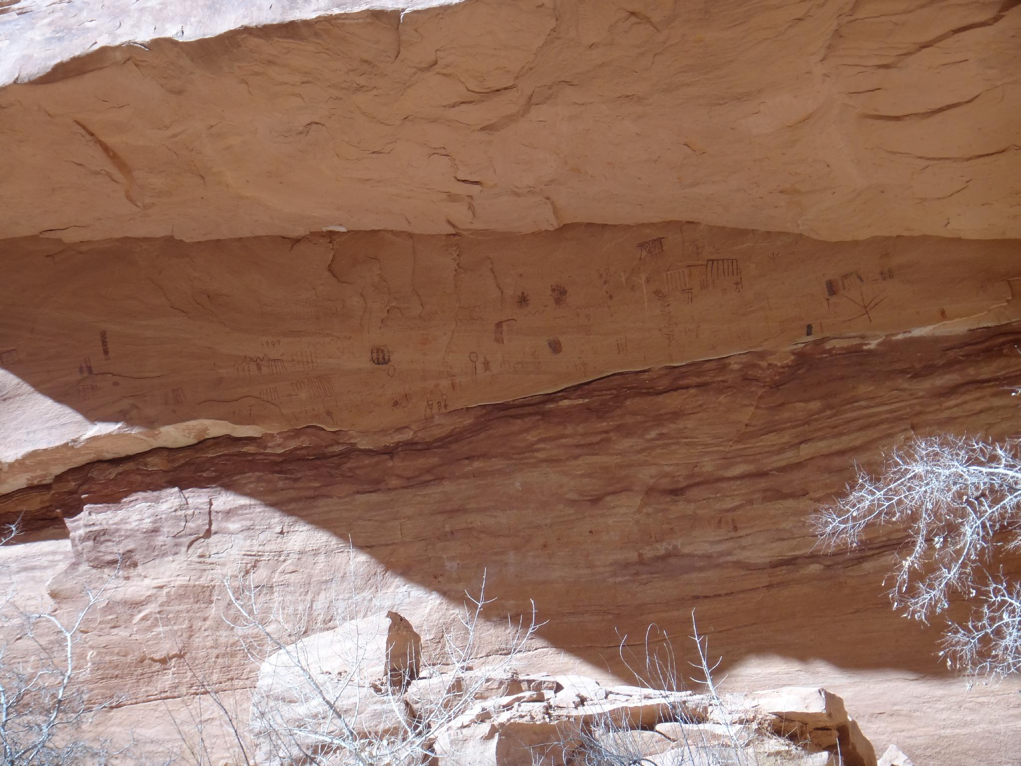
The rock art is the most notable feature of the Green Mask site, including the green mask for which the site is named. Based on the rock art styles in this alcove, this site has offered shelter to people for thousands of years. There is evidence of occupation dating from the Archaic period (6500 - 1500 BC) through the late habitation of Puebloan people around 1260 AD.
On the eastern end of the alcove, high on the wall and the ceiling is the colorful work of the artisans of the hunters and gatherers of the Archaic Period (6500 - 1500 BC). In pigments of black, red, white, and cream are abstract paintings of plant and insect-like forms, as well as other typical images of the period.
The large rock boulders around you on the alcove floor and the reddish rock scar on the wall directly below the Archaic paintings indicate there may have been a rock shelf used to access the upper wall. Basketmaker Period (BC 500–750 AD) style rock image over the rock scar reveals the shelf may have fallen before the occupation of the site.
Painted images midway and lower on the back wall of the alcove are also Basketmaker style. The Basketmaker style includes square-shouldered humanlike figures often with headdresses, positive handprints, bighorn sheep, lines, dots, and zigzags.
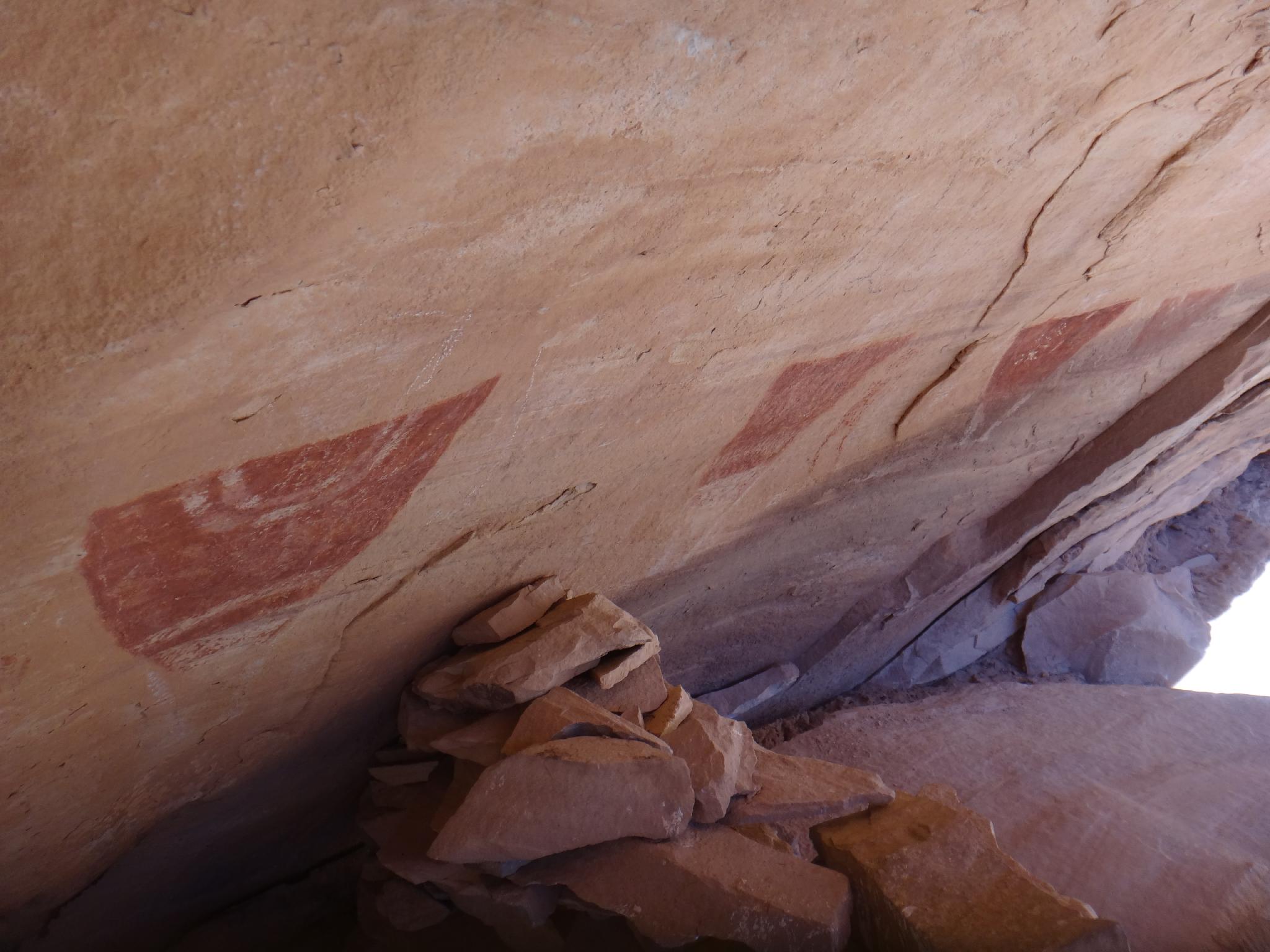
High on the far east end of the alcove is the elaborately painted mask-like figure in green, yellow, white, and red pigments. In a Basketmaker Period burial site in northeast Arizona, a full-face scalp or mask was found that had green and yellow stripes and red bobbed hair, almost identical to the mask painted on this wall.
The rock art of the Pueblo period was often less abstract than that of previous periods. These styles included shield-like figures, concentric circles, spirals, pawprints, handprints, bighorn sheep, birds, and mud balls.
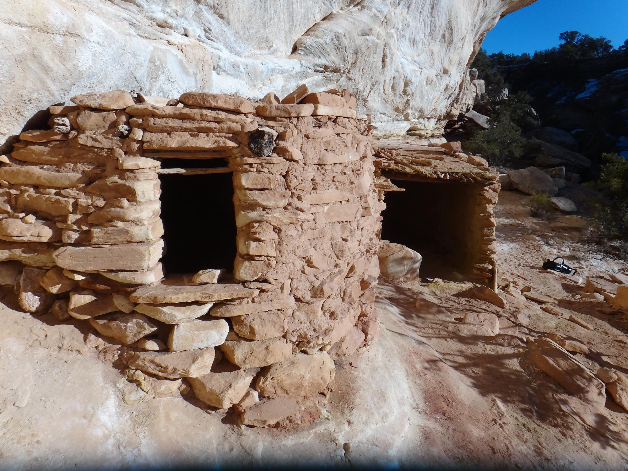
It is thought that this site may have had as many as 13 structures. There are several small below-ground storage units called cysts, and two above-ground structures on the lower level of the site that have curved walls could have been kivas.
In the 1890s, early explorers Charles McLoyd, C. C. Graham, C. H. Green, and their teams excavated human burials for private collections and museums. Many of the artifacts were exhibited in major cities and sparked public interest in the archaeology of the Southwest.
On the upper level of the southwest end of the Green Mask site are signature inscriptions of “C. McLoyd and C. C. Graham.” The signatures are an essential link to the story of the site. Archeologists and historians have traced some of the extracted artifacts back to the specific site from which they were taken by using these inscriptions along with expedition journals and statements of expedition participants.
Photos
Maps

12S 590408E 4145079N
37°26'53"N 109°58'40"W
12S 589930E 4145184N
37°26'57"N 109°58'60"W
12S 589445E 4145443N
37°27'06"N 109°59'19"W
12S 589130E 4145714N
37°27'14"N 109°59'32"W
12S 588679E 4145645N
37°27'12"N 109°59'50"W
12S 588579E 4145672N
37°27'13"N 109°59'55"W
12S 586947E 4145633N
37°27'13"N 110°01'01"W
12S 586493E 4145564N
37°27'10"N 110°01'19"W
12S 585873E 4145485N
37°27'08"N 110°01'45"W
12S 585692E 4145077N
37°26'55"N 110°01'52"W
12S 585250E 4144868N
37°26'48"N 110°02'10"W
12S 586927E 4145674N
37°27'14"N 110°01'02"W