 Hiking
Bullet Canyon
Hiking
Bullet Canyon
Grand Gulch
Overview
Home of the Perfect Kiva Ruin and Jailhouse Ruins, Bullet Canyon is one of the must visit side canyons of Grand Gulch. This is an astounding area dotted with ruins and high canyon walls.
Bullet can be visited as a down and back day hike, but is long (14 miles round trip to the Grand Gulch junction and back), and is better done as a loop up Sheiks Canyon. Just visiting Perfect Kiva and Jailhouse is about 10 miles round trip, while the loop returning via Sheiks is only a few miles more and sees much, much more.
If doing the Bullet/Sheiks loop, it is a long day or very pleasant overnight backpack (permit required, see the Cedar Mesa page for more information). I would recommend down Bullet and up Sheiks. This gets the slog over first, and allows the rest of the trip to be full of ruins and pictographs. Doing the loop requires either 2 cars, a mountain bike, or the willingness to add 3.25 miles to the hike for the shuttle.
Getting There
The trailhead is reached off of highway 261, which runs from near Natural Bridges south to near Mexican Hat.
From the north (highway 95/261 junction) go south about 11 miles to milepost 21.8 and 21.8 miles north of the junction with highway 163 if coming from the south.
Route Description
Rock art and historic sites are fragile, non-renewable cultural resources that, once damaged, can never be replaced. To ensure they are protected, please:
- Avoid Touching the Petroglyphs: Look and observe, BUT DO NOT TOUCH!
- Stay on the Trails: Stay on the most used trails when visiting sites, and don't create new trails or trample vegetation.
- Photography and Sketching is Allowed: Do not introduce any foreign substance to enhance the carved and pecked images for photographic or drawing purposes. Altering, defacing, or damaging the petroglyphs is against the law -- even if the damage is unintentional.
- Pets: Keep pets on a leash and clean up after them.
- Artifacts: If you happen to come across sherds (broken pottery) or lithics (flakes of stone tools), leave them where you see them. Once they are moved or removed, a piece of the past is forever lost.
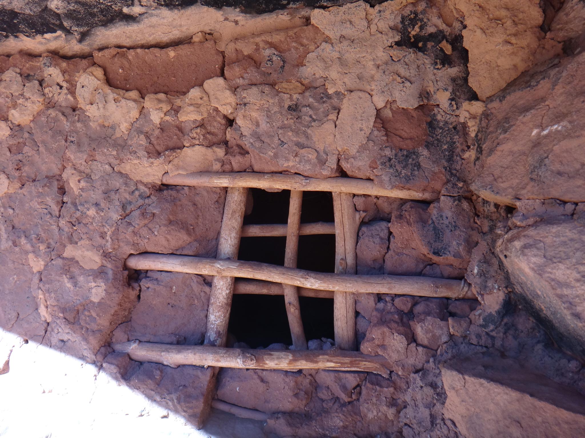
To Perfect Kiva (about 4.5 miles / 2 hours)
Follow the trail down Bullet Canyon. Rim Ruin becomes visible in less than 20 minutes on the right and is easy to spot from the canyon floor.
Continue down for about 4.5 miles to Perfect Kiva Ruin up a short side drainage on the right.
Welcome to "Perfect Kiva" in Bullet Canyon (formally Graham Canyon). You are standing at one of the most recent sites to be occupied on Cedar Mesa and one the first to be excavated, if not the first. Archaeologists have established a chronology for the prehistoric people of the Southwest that lists Archaic (6500 B.C. to 1500 B.C.), Basketmaker (1500 B.C. to A.D. 700), Pueblo (A.D. 750 to 900), Pueblo II (A.D. 900 to 1150), Pueblo III (A.D. 1150 to 1300), Pueblo IV (A.D. 1300 to 1600), and Pueblo V (A.D. 1600 to present). Some of the rock art present at "Perfect Kiva" indicates that the site was first established during the Basketmaker period. The structures you see now are from the Pueblo II and III periods. The first recorded or documented discovery of the site occurred in 1891.
The Navajo call the people that inhabited the Cedar Mesa area the "Anasazi". Many decedents, the Hopi in northeastern Arizona, the Zuni in west central New Mexico, and the Pueblos along the Rio Grande in New Mexico prefer that they are called Ancestral Puebloans. The Hopi refer to them as Hisatsinom. The oral traditions of the Hopi tell of many migrations among their ancestors in the American Southwest. The Hopi believe that these clans left markers through pictographs and petroglyphs to show that they had been at these places or performed certain ceremonies. Many archaeologists also agree with the Hopi migration beliefs. They believe that these migrations took place during three distinct time phases with two to three hundred years in between. These periods are approximately A.D. 200 to 400, A.D. 650 to 725, and A.D. 1060 to 1270.
EARLY EXPLORATION AT "PERFECT KIVA"
Charles McLoyd and Charles Cary Graham of Durango, CO organized the first expedition into Grand Gulch for the purpose of archaeological excavations in January of 1891. Many people feel that these early expeditions by McLoyd, Graham, and others like Richard Wetherill were primarily hunting missions with no archeological training. One has to remember that archeology was a very new field/science at the time and that very few standards had been established.
Before McLoyd and Graham could begin excavating in Grand Gulch and its many side canyons, they first had to find a way to get their horses and supplies down into the canyon bottom. To do this they established a trail into Bullet Canyon a few miles above "Perfect Kiva" on the south-facing canyon side using rock cribbing. This must have been a tremendous amount of work, but work that would have been considered completely worthwhile once they discovered pristine sites like "Perfect Kiva" and "Jailhouse". In the crude field notes that still exist from the McLoyd and Graham expedition, they labeled "Perfect Kiva" Cave #1 and "Jailhouse" Cave #2. This suggests that these might have been the first two sites that the men excavated if their system was in sequential order. Many of these early explorers left their signatures in charcoal or bullet lead on the alcove's walls and rocks. Some of these signatures can be seen here at "Perfect Kiva".
The Wetherill-Grand Gulch Research Project (1986 to 1990) used these signatures of explorers to trace and confirm the early routes of their expeditions. They proved to be a valuable insight into what people associated with the project have termed "reverse archaeology", so please respect and do not touch these valuable signatures. It is a well-known fact that hundreds of artifacts and human remains were sold and shipped to museums throughout the United States, some even to Sweden. Although many of the museums have known the collections were from the Grand Gulch / Cedar Mesa area, it has not been known from which exact site location the artifacts were originally found. The Wetherill-Grand Gulch Project succeeded in establishing the location of many artifacts to specific sites, thus the term "reverse archaeology" or working from original notes, and photographs back to locate the site.
Perfect Kiva to Grand Gulch (2.5 miles / 1-1.5 hours)
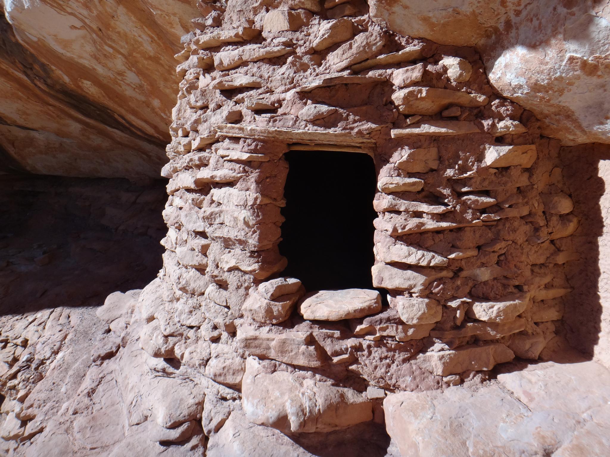
20 - 30 minutes down from Perfect Kiva is Jailhouse ruin on the right. It can be approached from the right or left.
From Jailhouse Ruin, you can see two granaries down the canyon on the right. There is generally a spring just a few minutes down canyon from Jailhouse Ruin. It is about an hour from Jail House to the junction with Grand Gulch. A very good granary is visible (and visitable) on the right about 10-15 minutes up from Grand Gulch.
Grand Gulch to Sheiks (about 1.6 miles / 1 hour)
Heading up Grand Gulch is lush and riparian. Follow the trail as it occasionally crosses the stream. Wall Ruin and a pictograph panel are on the left not far up Grand Gulch. They are just above the stream and hard to miss. The reverse hand prints here are stunning.
From Wall Ruin, it seems easiest to stay on the slickrock bench on the west side and follow it upstream. A surprisingly good ruin is on the left behind an abandoned rincon.
Stay on the bench, meandering around to Cave Ruin. This one is difficult to access and in poor shape. Re-enter the water course here. Just up from Cave Ruin, Sheiks Canyon comes in on the right.
Up Sheiks a few minutes, just before a spring and riparian area, is Green Mask ruins on the left (north side). If you're struggling to find the Green Mask proper, look up! It is high on the east side, near the spring with a large panel. There is a lot to see at the site. I've visited in the morning and afternoons and prefer midday/afternoon light.
Welcome to Sheiks Canyon and the Green Mask Site
The rock art is the most notable feature of the Green Mask site, including the green mask for which the site is named. Based on the rock art styles in this alcove, this site has offered shelter to people for thousands of years. There is evidence of occupation dating from the Archaic period (6500 - 1500 BC) through the late habitation of Puebloan people around 1260 AD.
On the eastern end of the alcove, high on the wall and the ceiling is the colorful work of the artisans of the hunters and gatherers of the Archaic Period (6500 - 1500 BC). In pigments of black, red, white, and cream are abstract paintings of plant and insect-like forms, as well as other typical images of the period.
The large rock boulders around you on the alcove floor and the reddish rock scar on the wall directly below the Archaic paintings indicate there may have been a rock shelf used to access the upper wall. Basketmaker Period (BC 500–750 AD) style rock image over the rock scar reveals the shelf may have fallen before the occupation of the site.
Painted images midway and lower on the back wall of the alcove are also Basketmaker style. The Basketmaker style includes square-shouldered humanlike figures often with headdresses, positive handprints, bighorn sheep, lines, dots, and zigzags.
High on the far east end of the alcove is the elaborately painted mask-like figure in green, yellow, white, and red pigments. In a Basketmaker Period burial site in northeast Arizona, a full-face scalp or mask was found that had green and yellow stripes and red bobbed hair, almost identical to the mask painted on this wall.
The rock art of the Pueblo period was often less abstract than that of previous periods. These styles included shield-like figures, concentric circles, spirals, pawprints, handprints, bighorn sheep, birds, and mud balls.
It is thought that this site may have had as many as 13 structures. There are several small below-ground storage units called cysts, and two above-ground structures on the lower level of the site that have curved walls could have been kivas.
In the 1890s, early explorers Charles McLoyd, C. C. Graham, C. H. Green, and their teams excavated human burials for private collections and museums. Many of the artifacts were exhibited in major cities and sparked public interest in the archaeology of the Southwest.
On the upper level of the southwest end of the Green Mask site are signature inscriptions of “C. McLoyd and C. C. Graham.” The signatures are an essential link to the story of the site. Archeologists and historians have traced some of the extracted artifacts back to the specific site from which they were taken by using these inscriptions along with expedition journals and statements of expedition participants.
Green Mask Ruin to Sheiks Trailhead (3.4 miles / 1.5-3 hours)
Work up Sheiks, staying on the social trails on the left (north). Just above the first bouldery section, a saddle on the left offers a nice viewpoint into Grand Gulch. It is worth the few minute side trip and looks down on The Thumb in Grand Gulch.
Keep working up, following a social trail. A large dryfall can be passed on the right or left with a little scrambling, right is the more common route. This marks the end of the steep section. From here Sheiks becomes wider, less steep, and easy going.
Keep your eye out as you head up Sheiks. A granary, or rather a couple of walls of a granary are visible on the left, followed by a very good granary close to the trail. Not far above the good granary are Yellow House Ruins, a well-preserved ruin complete with roof lashings. Stay left here to get around a small fall, and then cross back to the right and the Sheiks Canyon trailhead in 10-20 minutes.
Maps
")
")
12S 592920E 4143192N
37°25'51"N 109°56'59"W
12S 592107E 4142862N
37°25'41"N 109°57'32"W
12S 587734E 4143712N
37°26'10"N 110°00'30"W
12S 587299E 4143895N
37°26'16"N 110°00'47"W
12S 587033E 4143751N
37°26'11"N 110°00'58"W
12S 585743E 4144053N
37°26'22"N 110°01'51"W
12S 585250E 4144868N
37°26'48"N 110°02'10"W
12S 585692E 4145077N
37°26'55"N 110°01'52"W
12S 585873E 4145485N
37°27'08"N 110°01'45"W
12S 586493E 4145564N
37°27'10"N 110°01'19"W
12S 586947E 4145633N
37°27'13"N 110°01'01"W
12S 586927E 4145674N
37°27'14"N 110°01'02"W
12S 588579E 4145672N
37°27'13"N 109°59'55"W
12S 588679E 4145645N
37°27'12"N 109°59'50"W
12S 589130E 4145714N
37°27'14"N 109°59'32"W
12S 589445E 4145443N
37°27'06"N 109°59'19"W
12S 589930E 4145184N
37°26'57"N 109°58'60"W
12S 590408E 4145079N
37°26'53"N 109°58'40"W