
 Adams Canyon
Davis County
Overview
One of the more popular hikes in the area, the upper Adams Canyon waterfall is a picturesque 40' waterfall tucked in the folds of Adams Canyon. I've visited a couple of times and always enjoyed the falls but also been surprised at the number of visitors. On a summer Saturday, the parking lot can be full reasonably early in the morning.
Don't let the crowds deter you, however, as the hike is beautiful and the falls themselves are an excellent destination. The route to the upper falls is steep and relatively long (about 4 miles round trip and over 1000' of gain along the way), with the last section being particularly steep and rocky. The difficulties and distance make this not suitable for all but a fun, adventurous outing for most.
For those looking for a much shorter outing, the Lower Adams Canyon Falls is only about 1.2 miles roundtrip from the trailhead. Though not as spectacular to my eye, it is a lovely falls. The falls are about 25 feet or so high.
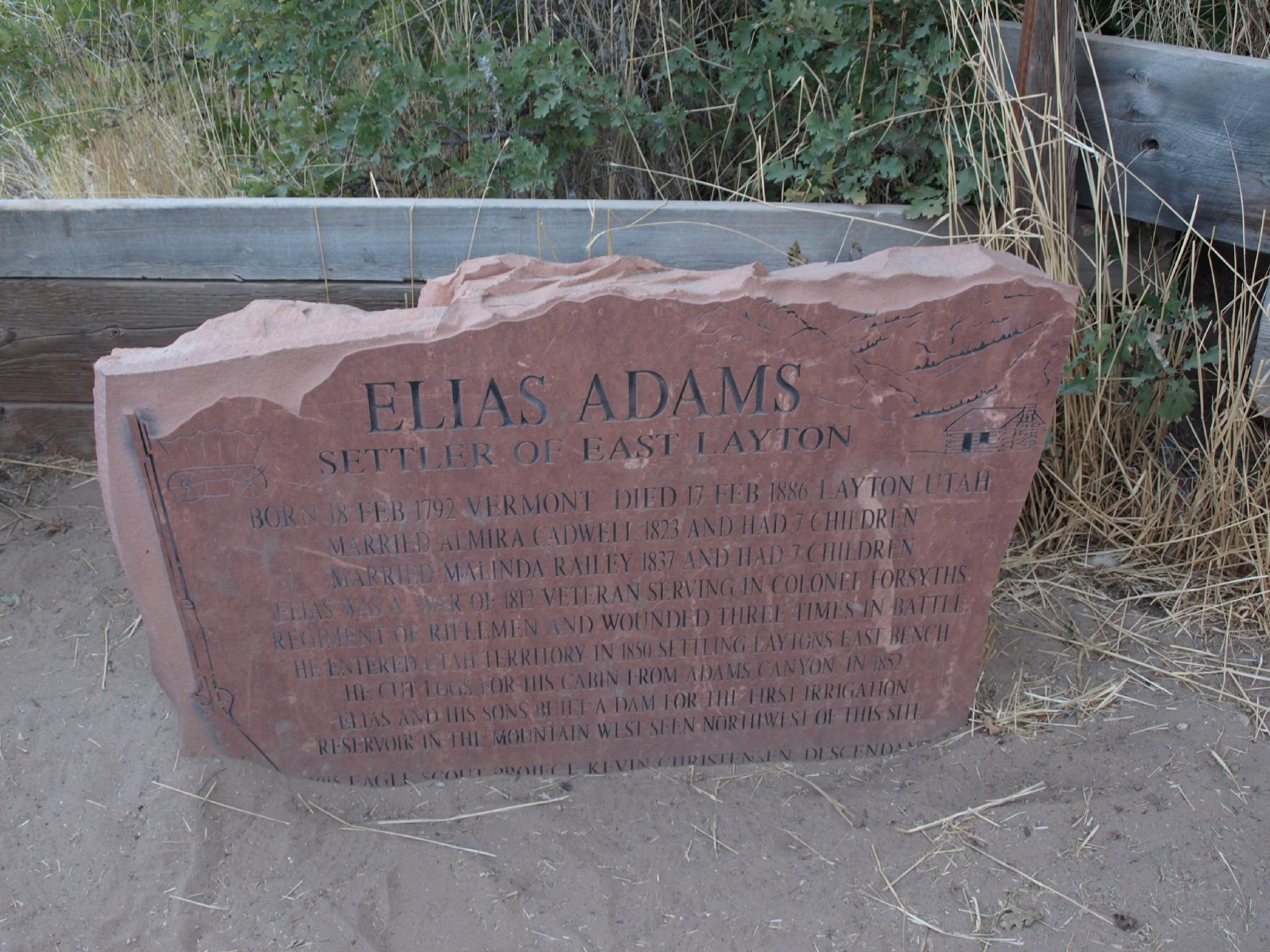
ELIAS ADAMS
SETTLER OF EAST LAYTON
BORN: 18 FEB 1792 VERMONT
DIED: 17 FEB 1886 LAYTON UTAH
MARRIED: ALMIRA CADWELL 1823 AND HAD 7 CHILDREN
MARRIED: MALINDA RAILEY 1837 AND HAD 7 CHILDREN
HISTORICAL NOTE: ELIAS WAS A WAR OF 1812 VETERAN SERVING IN COLONEL FORSYTHS REGIMENT OF RIFLEMEN AND WOUNDED THREE TIMES IN BATTLE. HE ENTERED UTAH TERRITORY IN 1850 SETTLING LAYTONS EAST BENCH. HE CUT LOGS FOR HIS CABIN FROM ADAMS CANYON. IN 1852 ELIAS AND HIS SONS BUILT A DAM FOR THE FIRST IRRIGATION RESERVOIR IN THE MOUNTAIN WEST SEEN NORTHWEST OF THIS SITE.
Getting There
The trailhead is off of US-89 near Fruit Heights. If coming from Salt Lake City, take the US-89 exit from I-15 about 10 miles north of Salt Lake, signed South Ogden. Follow this for about 6 miles to the Oak Hills Drive exit. Once off US-89, turn right, then left on Eastside Drive.
The parking area is here on the right, with an overflow parking area on the left. There is a restroom and water fountain at the trailhead.
Route Description
From the trailhead, the trail follows a fence line to the first switchback, where it quickly climbs a series of 11 or so switchbacks, gaining elevation. Between about switchback 10 and 11 is a bench and side trails on the right, a major side trail before and a major side trail after the bench. Both side trails go to the smaller Lower Adams Canyon Falls; stay left on the main path to go to the upper falls.
Lower Falls (0.3 miles from the main trail one way): To visit the lower falls, take the first side trail before the bench; it seems to be the most used. The side trail descends a bit, then meanders up to the lower falls, about 0.3 miles from the trail junction.
Once up the switchbacks, the trail mercifully flattens out and joins the Bonneville Shoreline Trail. Stay right at the Bonneville Shoreline junction, as the trail heads southeast and begins contouring into Adams Canyon.
About 0.75 miles from the trailhead, another junction is reached. Right stays on the Bonneville Shoreline Trail, crossing Adams Canyon on a bridge. Stay straight instead, in the bottom of Adams Canyon.
The scenery, in my opinion, gets better in this section as the trail climbs Adams Canyon. Shade becomes plentiful!
A log bridge is the next major landmark. Beyond the bridge, several steep, rocky sections occur, with quite a few braided side trails. Stay on whatever seems to be the main trail, as they all appear to head up canyon to the falls.
Photos
Maps

12T 423550E 4546519N
41°03'59"N 111°54'36"W
12T 423787E 4546554N
41°04'00"N 111°54'26"W
12T 424043E 4546386N
41°03'55"N 111°54'15"W
12T 423820E 4546558N
41°04'00"N 111°54'24"W
12T 424082E 4546526N
41°03'59"N 111°54'13"W
12T 424394E 4546521N
41°03'59"N 111°53'60"W
12T 425623E 4546608N
41°04'02"N 111°53'07"W