 Hiking
Crystal Wash
Hiking
Crystal Wash
Crystal Springs
Overview
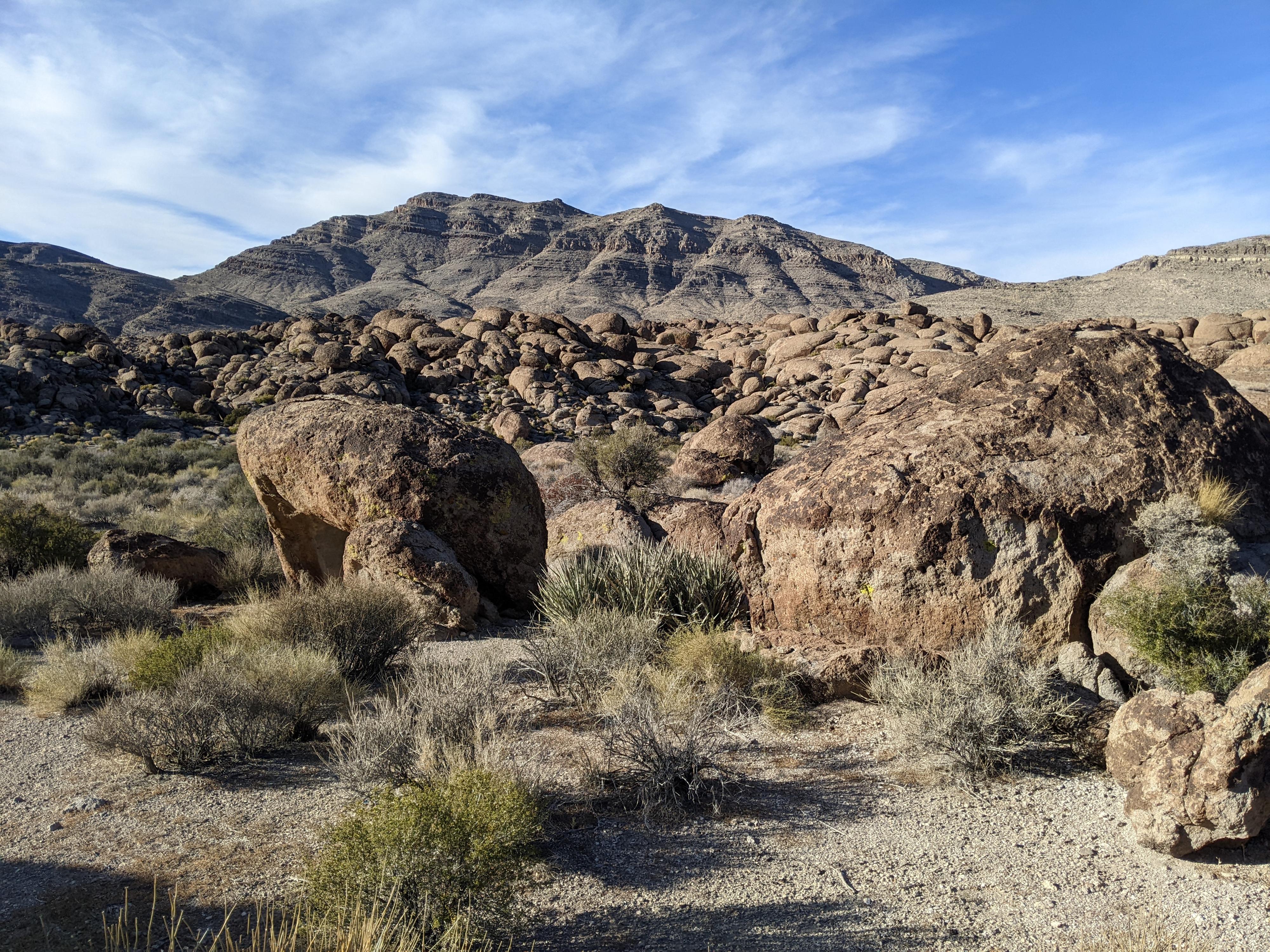
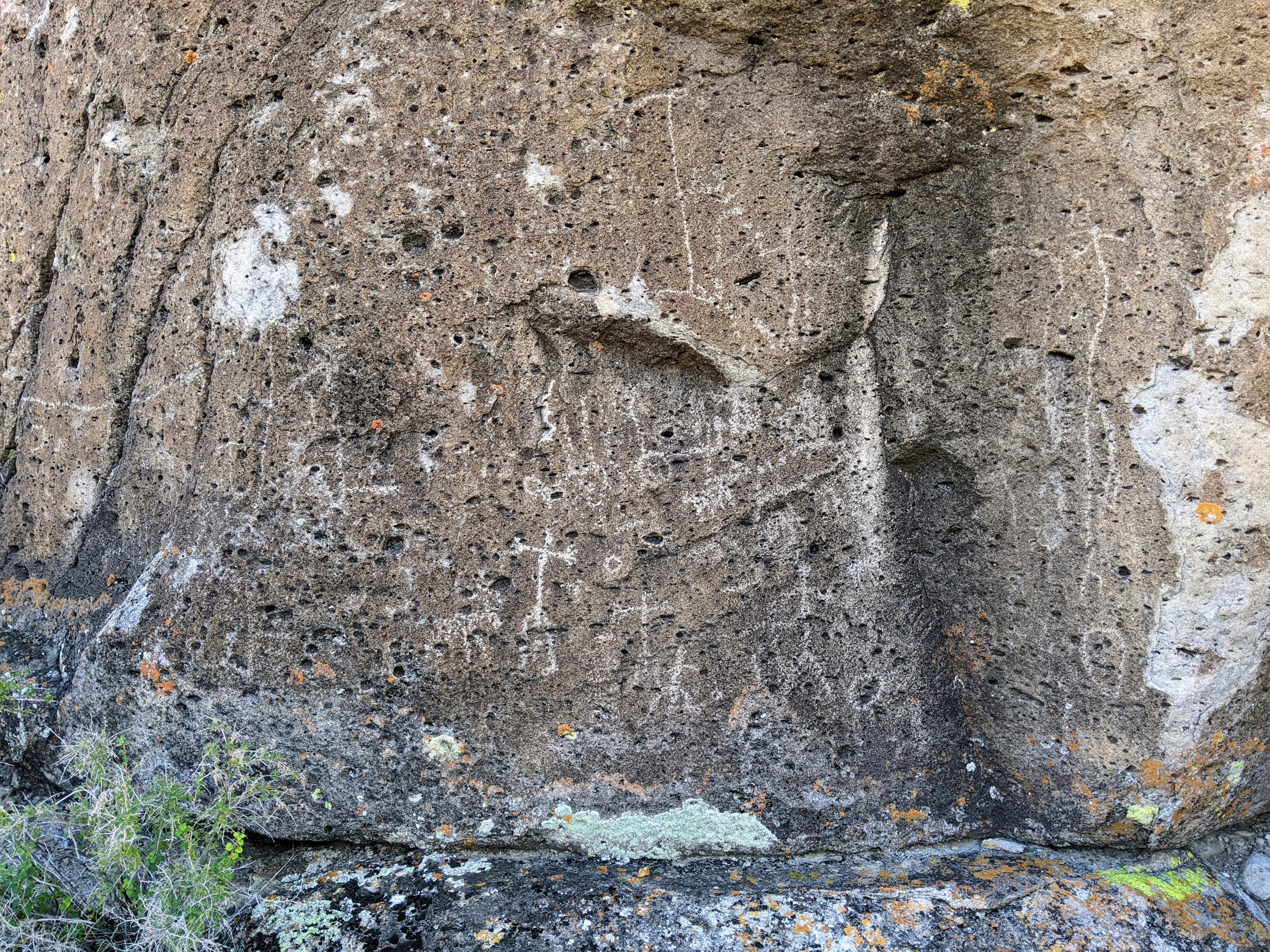
Near Crystal Springs, Nevada sits Crystal Wash, the site of a fairly extensive rock art site. The main area on the east side of Crystal Wash is thought to have been a winter habitation site for the Pahranagats, similar to the nearby Ash Springs Rock Art Site. The west side has rock art as well, but does not appear to have been inhabited like the east side.
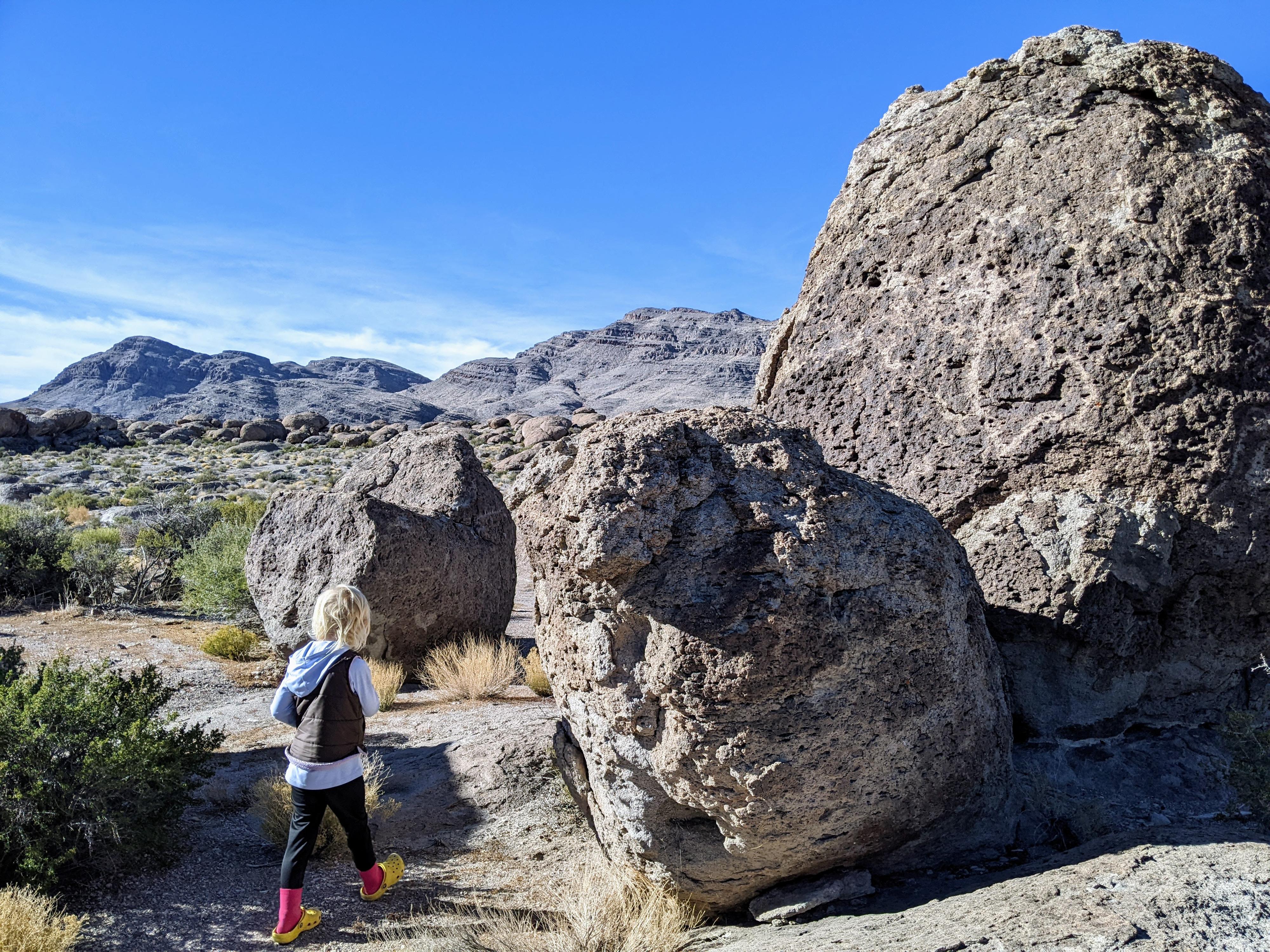
Crystal Wash is composed of large granite outcroppings and boulders. Rock art is scattered throughout the outcroppings and boulders, almost as though it were a path or maybe in an order to tell some story. It is a fascinating place. You can visit either the east (main) site, or the west site via a short hike. I would recommend, however, visiting both sites via through hike from the east to the west. If you have two cars, this can be done as a one-way hike. Even with one vehicle, the out and back is a very reasonable and interesting hike.
Getting There
East Side (Main) Trailhead
The east side trailhead is reached by turning north off US-93 just past mile marker 55. This is about 3.9 miles east of the junction of US-93 and SR-318 near Crystal Springs.
Once you turn off US-93, go through the fence. On the other side of the fence is a junction. Right goes northeast. Go LEFT here. Almost immediately, another junction is reached. This is the junction for the old shepherd camp. To visit the shepherds camp, go left here for a few hundred feet to the main area of the old shepherd camp.
To the rock art, go right instead, heading north, and follow the road to its end at the trailhead. It is about 0.7 miles from US-93 to the trailhead.
West Side Trailhead
The trailhead is just off US-93 about 0.2 miles past mile marker 54. This is about 3 miles east of the junction of US-93 and SR-318 near Crystal Springs. There is a small side road here that goes to the fence, with a spot for people to be able to walk through the fence. This is the trailhead.
Route Description
Rock art and historic sites are fragile, non-renewable cultural resources that, once damaged, can never be replaced. To ensure they are protected, please:
- Avoid Touching the Petroglyphs: Look and observe, BUT DO NOT TOUCH!
- Stay on the Trails: Stay on the most used trails when visiting sites, and don't create new trails or trample vegetation.
- Photography and Sketching is Allowed: Do not introduce any foreign substance to enhance the carved and pecked images for photographic or drawing purposes. Altering, defacing, or damaging the petroglyphs is against the law -- even if the damage is unintentional.
- Pets: Keep pets on a leash and clean up after them.
- Artifacts: If you happen to come across sherds (broken pottery) or lithics (flakes of stone tools), leave them where you see them. Once they are moved or removed, a piece of the past is forever lost.
Main (East) Entrance
From the trailhead, site 1 is about 100 northeast on the large boulder. After visiting site 1, head to the wash proper and go down (west) the wash.
About 1/4 of a mile downstream from the trailhead, the wash passes boulders on the left, then a side wash comes in before more boulders on the left. Sites 2 and 3 are in the second boulders just after the wash. This is also the easiest route from the main area to the west side, so make a mental note of it.
From sites 2 and 3, follow the wash downstream for another minute or two until boulders come close to the wash on both sides. From here, make a loop by going right and following the boulders in a circle back to sites 2 and 3. See the map for the locations, but sites 4,5 and 6 are close to the wash. Sites 7-10 are on the backsides of boulders about 0.2 miles from the wash. Circle back to sites 2/3 after visiting #10.
If just visiting the main site, return by going back up the wash to the trailhead.
East Route to West Entrance
If continuing through to the west entrance, the easiest path is to go east from sites 2/3 to the wash bottom, then follow it downstream. When a major comes in on the right, look for west entrance site 4. This major wash comes in about a 1/2 mile from leaving site 2.
See West Entrance section below for the sites lower in Crystal Wash.
Alternate Route To The West Entrance:
A more challenging, and I think more interesting, route to the west entrance is to head from sites 4 into the drainage heading southwest. This requires minor scrambling and comes to a short slot. If the slot has water or the first down climb into it seems too difficult, bypass it on the right and re-enter below the slot. Follow this canyon down to its junction with a major wash coming in on the left. This is the Easy Route wash described above. West entrance site #4 is at the confluence of this drainage and the Easy Route.
West Entrance
From the trailhead, cross through the passage in the fence and head to the wash bottom on the social trail. Follow the wash upstream. West side sites 1 and 2 are in the wash right when the wash becomes boulder lined on both walls. For sites 3 and 4, continue up the wash. Site 3 is only about 300 feet upstream from site 1. Site 4 is about 700 feet upstream from site 1.
Sites 5 and 6 are very difficult to describe, as they are up out of the wash in the maze of boulders and cliffs. From site 1, head south up the hill. You will pass around a small ridge and see a small valley. On the other side of the valley is site 6, with site 5 nearby. We saw site 6 from a distance, so keep an eye out as you hike.
Return the same way.
Photos
Maps


11S 662407E 4158230N
37°33'24"N 115°09'41"W
11S 661075E 4157454N
37°33'00"N 115°10'36"W
11S 662696E 4157276N
37°32'53"N 115°09'30"W
11S 661336E 4157452N
37°32'60"N 115°10'25"W
11S 662548E 4157433N
37°32'58"N 115°09'36"W
11S 661898E 4158132N
37°33'22"N 115°10'01"W
11S 661880E 4158135N
37°33'22"N 115°10'02"W
11S 661889E 4158116N
37°33'21"N 115°10'02"W
11S 661885E 4158109N
37°33'21"N 115°10'02"W
11S 661925E 4158040N
37°33'19"N 115°10'00"W
11S 661950E 4158021N
37°33'18"N 115°09'59"W
11S 661945E 4158021N
37°33'18"N 115°09'60"W
11S 662055E 4158047N
37°33'19"N 115°09'55"W
11S 662045E 4158084N
37°33'20"N 115°09'56"W
11S 662425E 4158250N
37°33'25"N 115°09'40"W
11S 661897E 4157936N
37°33'15"N 115°10'02"W
11S 661487E 4157800N
37°33'11"N 115°10'18"W
11S 661464E 4157813N
37°33'12"N 115°10'19"W
11S 661533E 4157851N
37°33'13"N 115°10'17"W
11S 661677E 4157833N
37°33'12"N 115°10'11"W
11S 661514E 4157719N
37°33'08"N 115°10'17"W
11S 661522E 4157712N
37°33'08"N 115°10'17"W