 Canyoneering
Navajo Knobs Technical Loop
Canyoneering
Navajo Knobs Technical Loop
Capitol Reef
Overview
Navajo Knobs is one of my favorite hikes in Capitol Reef. If you are a hiker, see the Rim Overlook and Navajo Knobs Trail for more information on the hike. The route described here is my attempt at turning the out-and-back Navajo Knobs hike into a loop and is a technical route requiring one rappel.
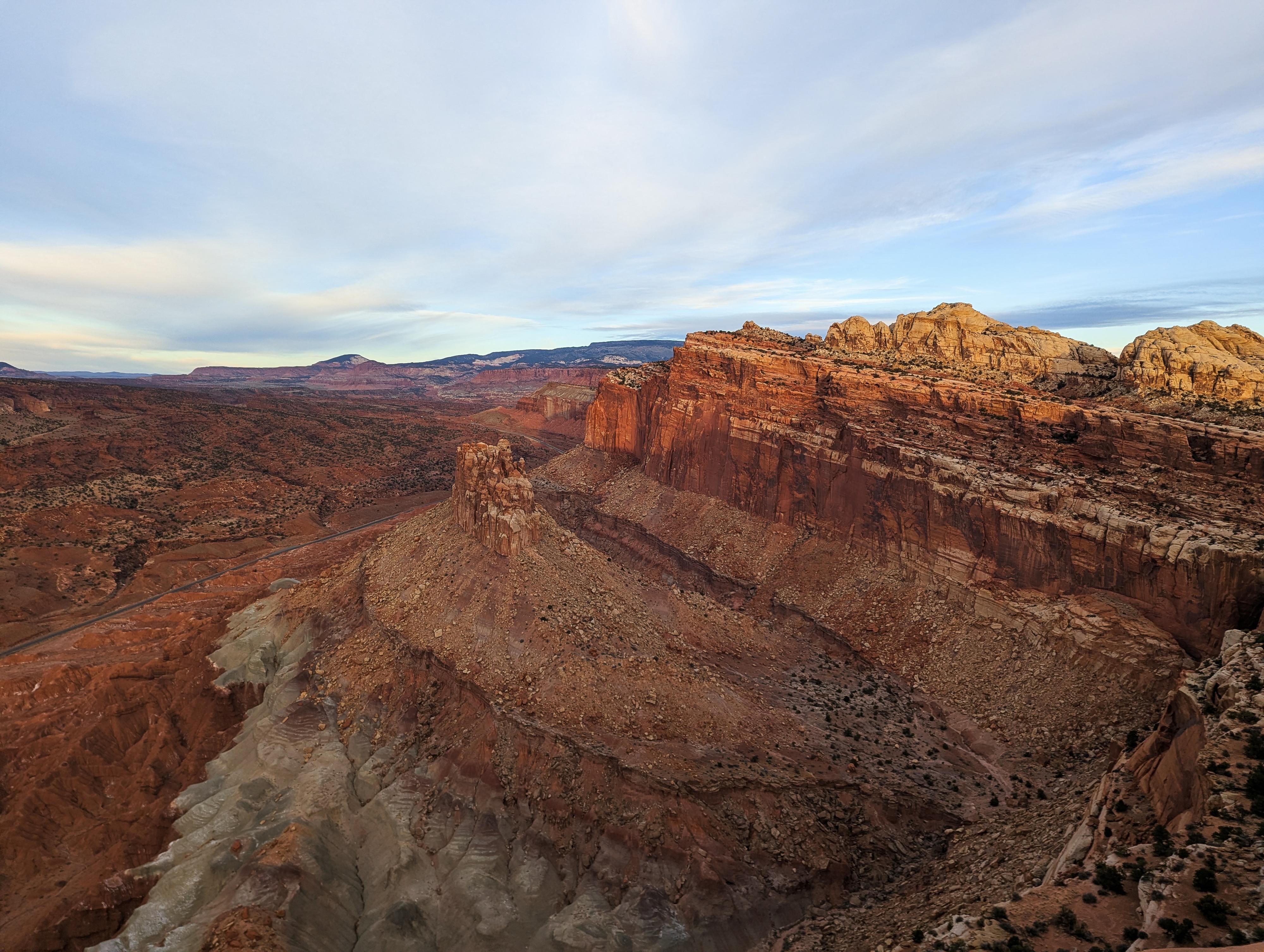
If you have ever done the Navajo Knobs hike, you may have stared down from the end of the trail at the colorful canyon below and wondered about it. This route hikes the usual Navajo Knobs Trail to the end. From the end of the trail, with some careful route finding, it descends to the colorful canyon. The colorful canyon is ascended to its head, where a single rappel deposits you on Whiskey Flat, and a short hike to the highway.
I had high hopes this would be an amazing route! I enjoyed it, but the canyon is very brushy! The thrashing, to me, took away a bit from the day. The rappel at the head of the canyon, down to Whiskey Flat, is a nice spot and makes for a great rappel. If you have two cars or a car and bike shuttle, this makes for about a 7-mile outing. If you walk the highway back to Hickman Bridge, it is close to 10 miles, and about the same or a little more than hiking the Navajo Knobs Trail as an out-and-back. Shuttle recommended, as walking next to the highway isn't that great.
Getting There
Hickman Bridge Trailhead (Starting Trailhead)
From the Visitor Center, travel east on Highway 24 about 2 miles to the signed Hickman Bridge trailhead on the north (left) side of the road (mile post 81.2). There is a pit toilet here.
Exit Trailhead (if using two vehicles)
From the Visitor Center, travel west on Highway 24 (toward Torrey) for a bit under 2 miles to a pullout on the left (south side) of the road at about mile post 77.85.

Route Description
Navajo Knobs Trail (4.5-ish miles)
From the trailhead, follow the Hickman Bridge Trail. After just a few minutes (0.3 miles) it splits. Left goes to Hickman Bridge; go right instead. After a few more minutes, there is a great viewpoint for Hickman Bridge. The trail should be easy to find and is well cairned, but be mindful of cryptobiotic soil.
After 1-1.5 hours, the Rim Overlook is reached. The view down into Fruita and the more distant views of the Waterpocket Fold and the Boulder Mountains to the south are excellent.
From the Rim Overlook, the trail continues contouring around and up toward the Navajo Knobs viewpoint. It meanders around, with amazing views of the cliffs immediately to the north and The Castle to the south near the visitors center. The trail ends at the overlook. Plan on about 2.5-3 hours from the trailhead to the overlook.
To the Canyon (3/4 of a mile)
The goal for the next section is to work down to the colorful canyon to the west, trending north to where the canyon is open. The terrain is ledgy, but with some careful route finding, this is non-technical.
From the end of the Navajo Knobs Trail, I headed generally down and a touch left. Keep an eye out on the right for a steep dirt hill in the distance a bit that goes down to near the colorful canyon rim. When possible, traverse over to the steep dirt slope and follow it down. Once on slickrock, pick whatever path looks easiest and head north along the canyon rim until it is easy to walk to the sandy canyon bottom.
To the Highway (1.3-ish miles)
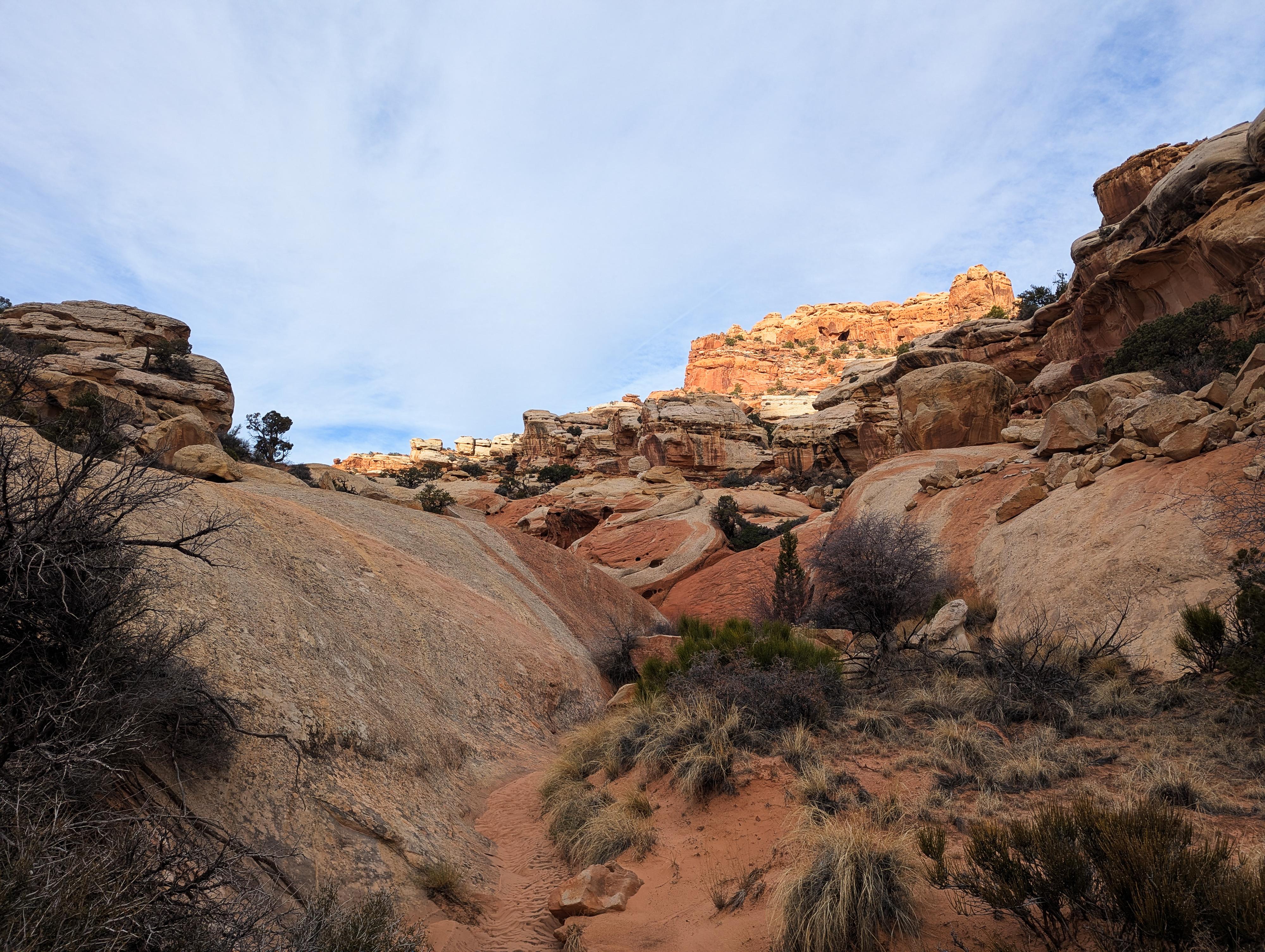
Head up the canyon. It is remarkably sandy and brushy. It must hold moisture after rain and seems much more vegetated than I expected. The canyon is easygoing, aside from the bushwhacking. It is not far to the head of the canyon, where it drops to Whiskey Flat and you can see UT-24 below. This is the one and only rappel on the route.
At the drop, a ledge can be walked on the left a short distance to some old bolts and wire. These don't appear to be climbing bolts but rather some sort of old telephone or electrical project. This is the shortest spot to rappel from, but none of the hardware appeared trustworthy to me. Instead, you will likely want to pick any of several large boulders at the head of the canyon proper. Depending on which anchor and how far you extend the webbing, you may be making up to about a 25 m rappel. The spot and anchor I used was about 20 m.
Once down, some boulder hopping ensues to get all the way down to the flat wash bottom. Stay generally close to the watercourse, though you have to deviate a little on the right to avoid a small drop near the bottom. Once down, follow the wash to UT-24.
If you have a shuttle, go right (west) on UT-24 a short distance to the pullout where you left the shuttle. Otherwise, it is about a 3.5 mile walk along the highway heading east back to the Hickman Bridge Trailhead. This is an easy walk, but a little unnerving with cars zooming by. Shuttle recommended.
Photos
Maps

12S 480092E 4237845N
38°17'18"N 111°13'40"W
12S 480201E 4237954N
38°17'22"N 111°13'35"W
12S 478186E 4238157N
38°17'28"N 111°14'58"W
12S 476396E 4239780N
38°18'21"N 111°16'12"W
12S 476765E 4240337N
38°18'39"N 111°15'57"W
12S 476272E 4240282N
38°18'37"N 111°16'17"W
12S 475391E 4239936N
38°18'26"N 111°16'53"W