 Hiking
Junction Ruin
Hiking
Junction Ruin
Grand Gulch
Overview
The Grand Gulch area, located within the Bears Ears region of Utah, holds one of the richest concentrations of ancestral sites in the American Southwest. Towering canyon walls and alcoves have thousands of years of human history preserved in cliff dwellings, rock art, and pottery shards. This is a place I had wanted to visit for years. When I finally visited, I found it to be one of the most incredible places I've visited on the Colorado Plateau.
The hike described here is a brief introduction to Grand Gulch: hiking down from the Kane Gulch Ranger Station to visit Junction Ruin and returning the same way. It makes for an excellent day hike and visits an impressive ruin. Kane Gulch, which I had not had any impression would be very interesting, is beautiful!
Important: You will need a permit for either day hiking or backpacking. See the permit link on this description. Day hiking permits are not currently limited, but do need to be purchased either online or at the ranger station which has limited hours.
History: Grand Gulch was home to people for thousands of years, with distinct periods of inhabitation.
Basketmaker II Period (ca. 500 BCE – 500 CE):
The earliest known farmers in the area. They grew corn and squash, lived in pithouses, and made finely woven baskets instead of pottery.
Basketmaker III Period (ca. 500 – 750 CE):
This period saw the introduction of pottery and the bow and arrow. Small villages began to appear, and people increasingly relied on agriculture.
Pueblo I to Pueblo III Periods (ca. 750 – 1300 CE):
The Basketmaker peoples evolved into the Ancestral Puebloans. They built aboveground stone and adobe structures, developed complex communities, and created the cliff dwellings and kivas seen in Grand Gulch.
After about 1300 CE, many of these ancestral communities migrated southward toward the Hopi Mesas, Zuni lands, and the Rio Grande Valley, likely due to prolonged drought and changing social dynamics. Yet, their descendants - the Hopi, Zuni, Acoma, and other Pueblo peoples - maintain a living connection to this sacred region, as do the Diné (Navajo) and Ute Mountain Ute, who later made the canyons part of their homelands.
Getting There
From Blanding, head south on US-191. In about 4 miles, turn right onto UT-95 North toward Hanksville. Follow UT-95N for about 28.4 miles to it's junction with UT-261. Head south on UT-261 toward Bluff/Mexican Hat for about 3.9 miles to where the ranger station is on the left (east) side of the road. There is a restroom at the ranger station, but no water available (as of 2025). This is at about mile post 28.7.
Route Description
Rock art and historic sites are fragile, non-renewable cultural resources that, once damaged, can never be replaced. To ensure they are protected, please:
- Avoid Touching the Petroglyphs: Look and observe, BUT DO NOT TOUCH!
- Stay on the Trails: Stay on the most used trails when visiting sites, and don't create new trails or trample vegetation.
- Photography and Sketching is Allowed: Do not introduce any foreign substance to enhance the carved and pecked images for photographic or drawing purposes. Altering, defacing, or damaging the petroglyphs is against the law -- even if the damage is unintentional.
- Pets: Keep pets on a leash and clean up after them.
- Artifacts: If you happen to come across sherds (broken pottery) or lithics (flakes of stone tools), leave them where you see them. Once they are moved or removed, a piece of the past is forever lost.
To Grand Gulch (2-3 hours)
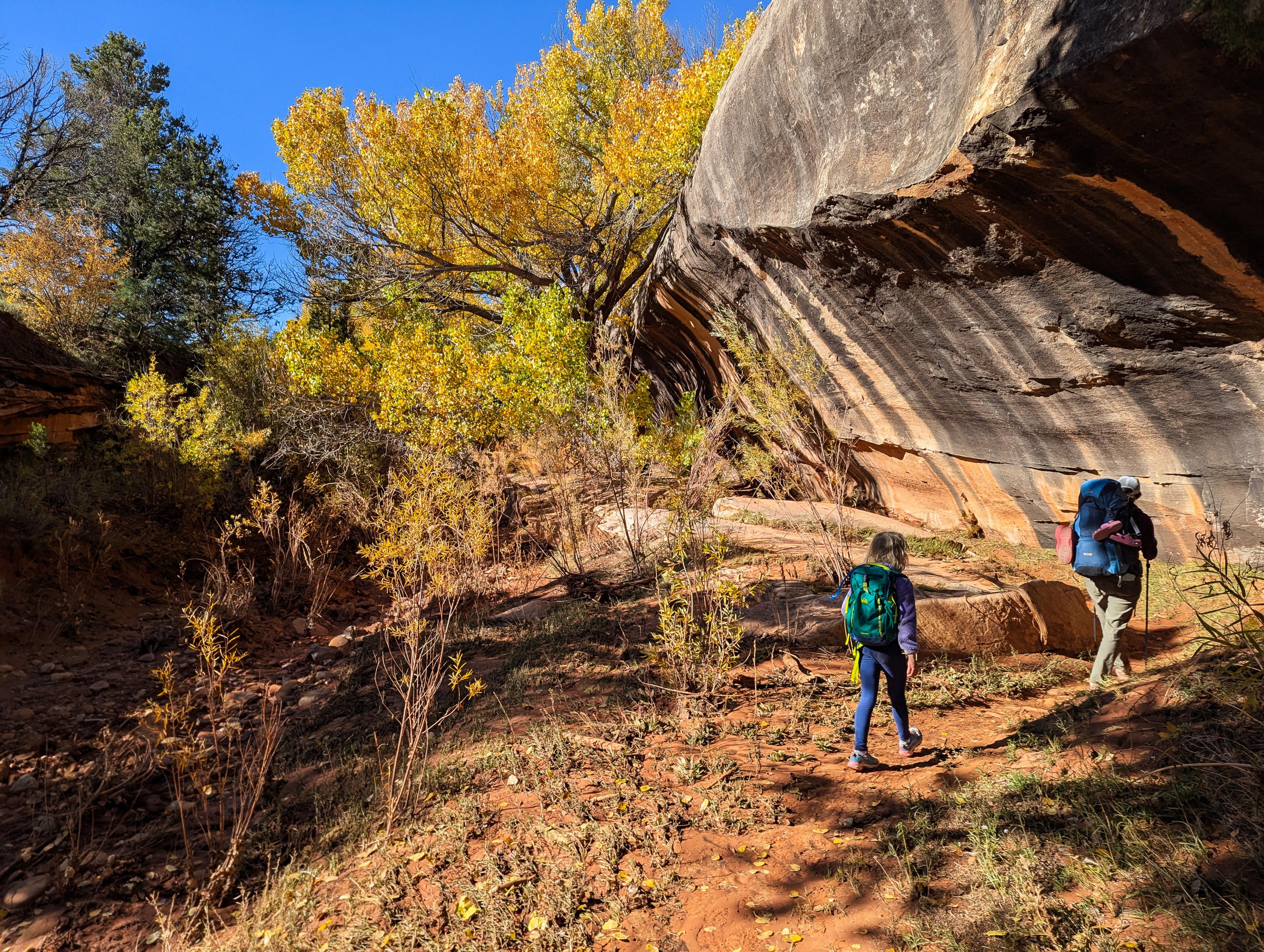
From the ranger station, cross the highway and begin following the trail down Kane Gulch. It is well-defined and easy to follow as long as you keep an eye out. Initially in the bottom of the canyon in a fairly wide and shallow canyon.
A little under a mile from Kane Gulch Ranger Station, the trail hugs the right wall through a narrow passage between a boulder and canyon wall. It is a neat spot!
Below the narrow passage, the canyon slowly deepens. From here, keep an eye out as the trail often leaves on the right to bypass obstacles.
It is about 4 miles from the ranger station to the confluence with Grand Gulch. There is usually a spring at the confluence.
To Junction Ruin
From the confluence, hike up Grand Gulch a minute or two. There is a large campsite under trees here on the left. Continue upstream a minute from the campsite to the large alcove on the left. You will see the ruins from a distance as you approach. It is a large and impressive site.
BLM Info
Junction Ruin
Grand Gulch Wilderness Study Area
Welcome to Junction Ruin.
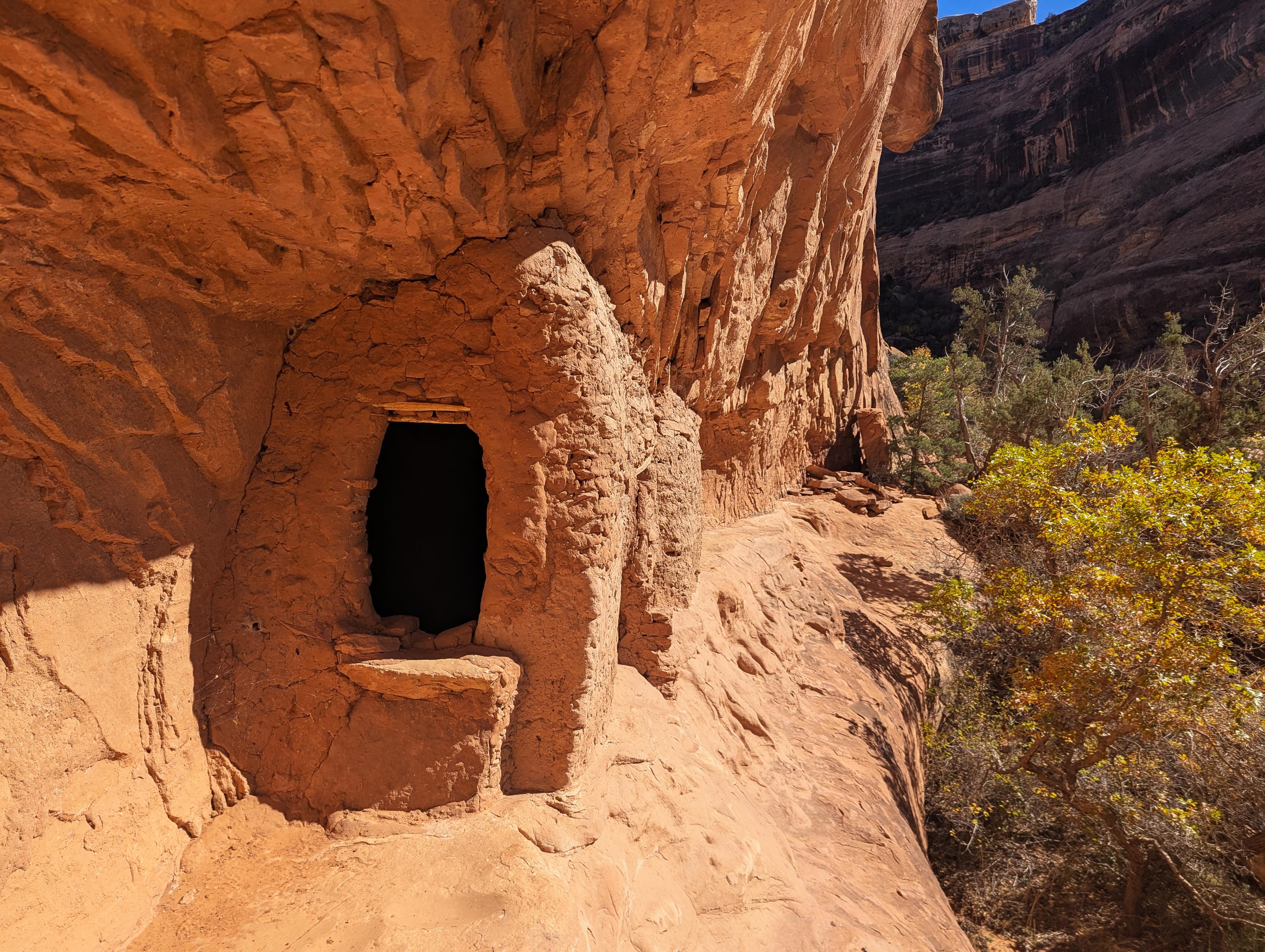
The site was named because of its location at the confluence of Grand Gulch and Kane Gulch. It dates to Basketmaker III times, though there is little evidence that remains. Pueblo II and III times are better represented. Junction Ruin is an extensive site consisting of three levels. The lower level contains 28 features, the middle includes 14, and the upper alcove, which is now inaccessible, consists of 17 features.
The function of individual structures may not always be apparent, but storage cysts and structures, habitation rooms, kivas, and defensive structures have all been identified at this site. There is also a strong representation of varying architectural types here, including both wet and dry laid adobe masonry and jacal, or wattle and daub (mud plastered over a mesh of sticks).
Specific structures like storage cysts and other above-ground structures were used to store food (corns, beans, and squash) or water. Storage structures tend to be smaller with smaller entryways, which would have been closed using a rock or door slab. At some of the storage units here, you can still see the lintel across the inside top of the doorway, which prevented the door slabs from falling inward. Storage units generally lack any soot and smoke blackening.
Habitation rooms tend to be larger and have thicker walls and a larger entrance than storage units. The walls and ceilings are typically blackened from smoke and soot, indicating that the Ancestral Puebloans made fires inside for warmth or cooking. Ventilators and deflectors are also generally present as a means of ventilating smoke from the structure, similar to a modern chimney.
Three of the features on the main lower level are kivas. They would have had roof beams and roofing material such as juniper bark, and an opening would have been present to enter from the roof into the kiva by use of a ladder. The ventilator shafts, small niches, benches, and plaster are still visible.
The defensive structures at this site have been identified as the entire upper level. To the left of the site and midway up is a ladder platform, which seems to have provided the only access to this upper level. If you look closely above this platform, you will see the remains of a portion of the original ladder, which has now been bolted into the wall for stabilization purposes.
The red mortar remnants on the ceilings and walls to the back of the alcove indicate that there had been a wall or previous structure there which has since fallen.
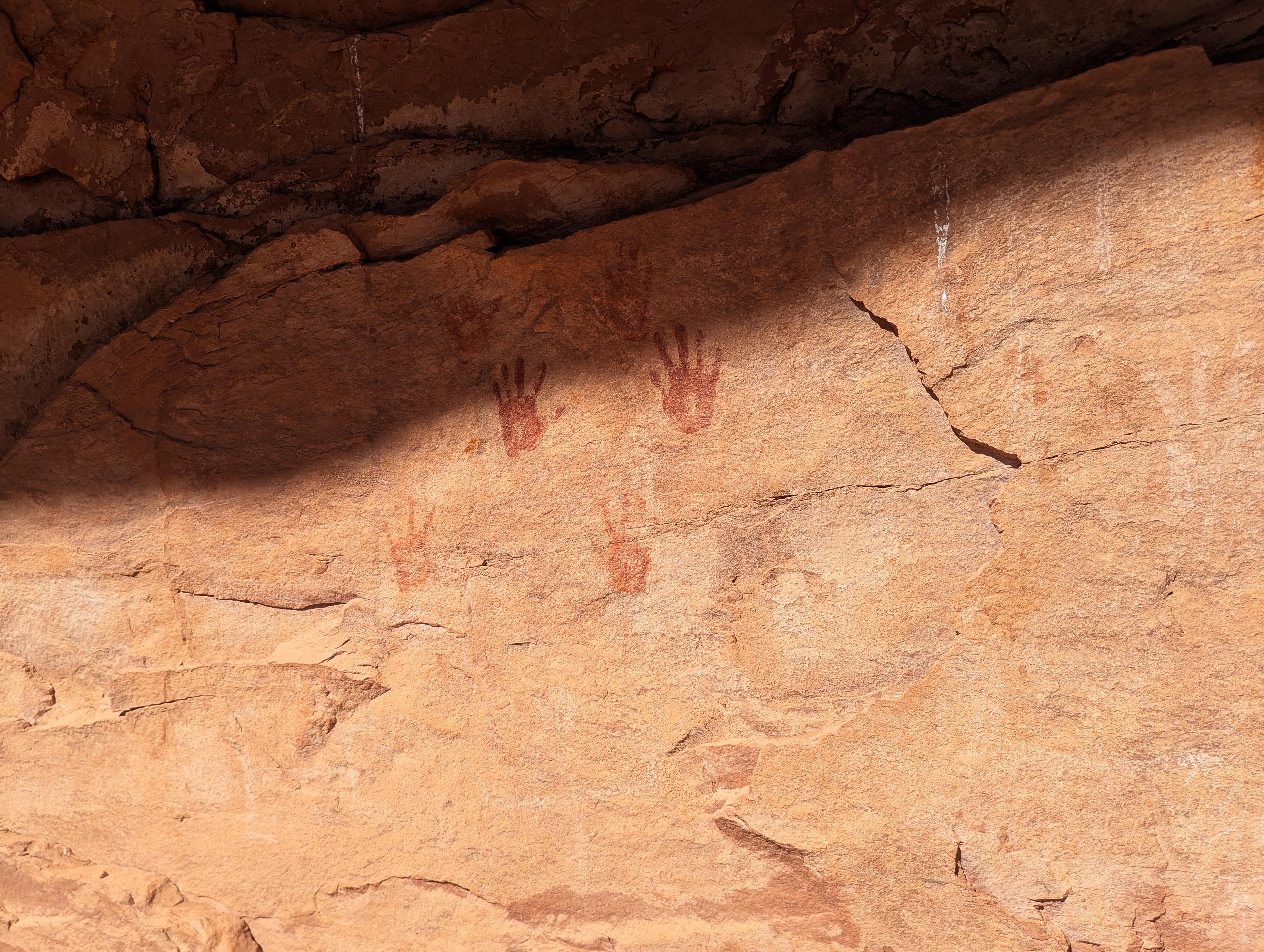
The rock art at the site includes both petroglyphs (pecked images) and pictographs (painted). There are numerous positive and negative handprints using white and red paint. Yellow and orange abstracts, spirals, and anthropomorphs are also present.
The large rock in the middle of the lower level contains many grinding areas, stone manos to grind corn, while many of the grooves may have been used for sharpening three grinding tools.
Some of the artifacts collected from this site by early archeologists included ceramics, ground stone, lithics, bone tools, and perishable artifacts including sandals, cordage, textiles, basketry, corn, squash, wood, hide, and coprolites. Information can be gained from these artifacts now and in the future with new and updated scientific technology.
The site was stabilized in 1965 and again in 1984. Careful site visitation helps in keeping this site from further deterioration. The rock art was documented in 1982 and was part of a research program in conjunction with the BLM and Earthwatch.
Side Trip to Turkey Pen Ruins and Stimper Arch (about 2 miles round-trip / 1-2 hours)
Head down Grand Gulch. Depending on recent floods, you will find a few social trails. Follow whatever social trail looks best heading down the canyon. Sometimes we found it easier to stay in the bottom of the streambed proper. It is a little under a mile to where Turkey Pen Ruin is visible on the right in a high overhang. This is best viewed with binoculars with the current closure.
If you continue down Grand Gulch, just around the next bend (about 1/4 of a mile) is Stimper Arch high on the left.
Return the same way you came.
BLM Info
Turkey Pen Closure Information:
April 18th, 2022
Turkey Pen is an archeological site located down the Kane Gulch trail in the Grand Gulch Wilderness Study Area.
In March 2022, BLM archeologists documented significant erosion and damage to cultural resources at Turkey Pen and other archeological sites in upper Grand Gulch caused by increased visitor use.
Turkey Pen is part of a broader cultural landscape that is sacred to sovereign Tribal Nations and Indigenous people of the southwest. The Bears Ears cultural landscape, and all archeological sites within it, was identified as a unique object in the Monument Proclamation.
To prevent erosion from irreversibly damaging sensitive cultural resources and ensure its proper care and management in accordance with the Antiquities Act of 1906, the BLM will temporarily restrict access to Turkey Pen and other archeological sites in upper Grand Gulch.
Turkey Pen can still be viewed with binoculars from the canyon bottom.
Photos
Videos
Kane Gulch to Sheiks Canyon
Maps

12S 597570E 4153623N
37°31'28"N 109°53'45"W
12S 597291E 4153544N
37°31'25"N 109°53'56"W
12S 596464E 4153102N
37°31'11"N 109°54'30"W
12S 593871E 4152249N
37°30'45"N 109°56'16"W
12S 593855E 4152358N
37°30'48"N 109°56'17"W
12S 593054E 4151962N
37°30'36"N 109°56'50"W
12S 593293E 4151738N
37°30'28"N 109°56'40"W