Homer and Marge Tower |

Kane Creek

Climbing Homer and Marge Tower - Kane Creek Climbing Homer and Marge Tower

Kane Creek

Overview

RATING: 5.5 C1
MAPS: TROUGH SPRINGS CANYON, UT; SHAFER BASIN, UT;

Tue

Sunny, with a high near 64. West southwest wind around 5 mph.

64 | 39

Wed

Sunny, with a high near 67. West southwest wind 0 to 10 mph.

67 | 40

Thu

Sunny, with a high near 70.

70 | 40

Fri

Sunny, with a high near 69.

69 | 44

Sat

Mostly sunny, with a high near 71.

71 | 46

View Full Weather Details
SEASON: Any, although summers can be hot.
GEAR: 50 m ( 165 ft. ) Rope – Quick draws – Stick Clip – Black Diamond #5 or equivalent, aid gear

Tue

Sunny, with a high near 64. West southwest wind around 5 mph.

64 | 39

Wed

Sunny, with a high near 67. West southwest wind 0 to 10 mph.

67 | 40

Thu

Sunny, with a high near 70.

70 | 40

Fri

Sunny, with a high near 69.

69 | 44

Sat

Mostly sunny, with a high near 71.

71 | 46

View Full Weather Details
Weird and fun tower climbing in Kane Creek!

Weird and fun tower climbing in Kane Creek!

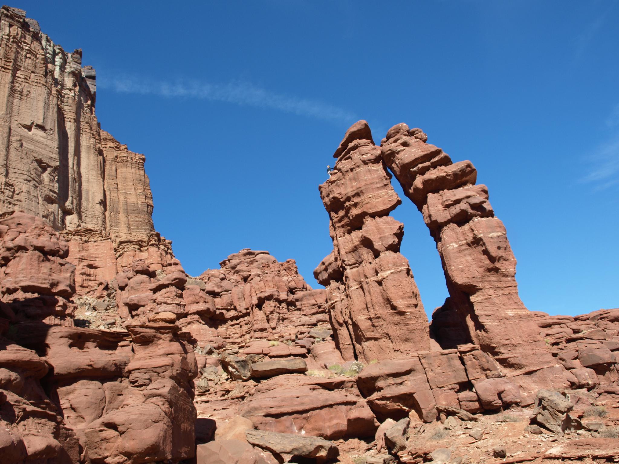
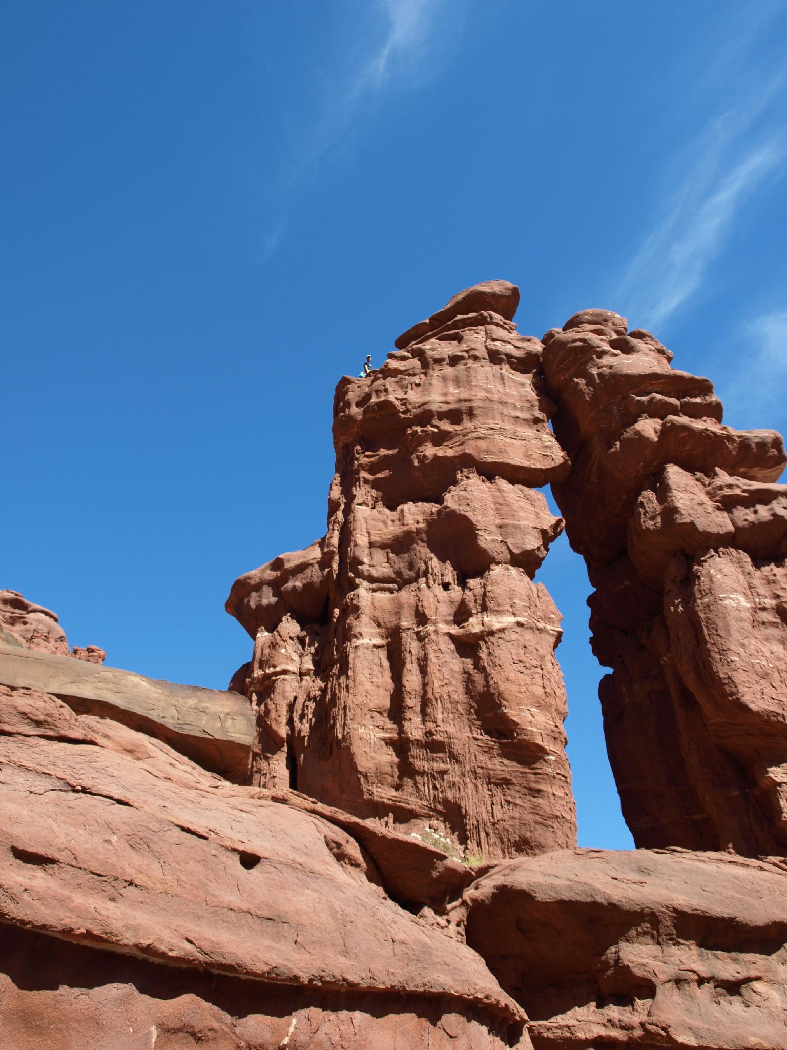
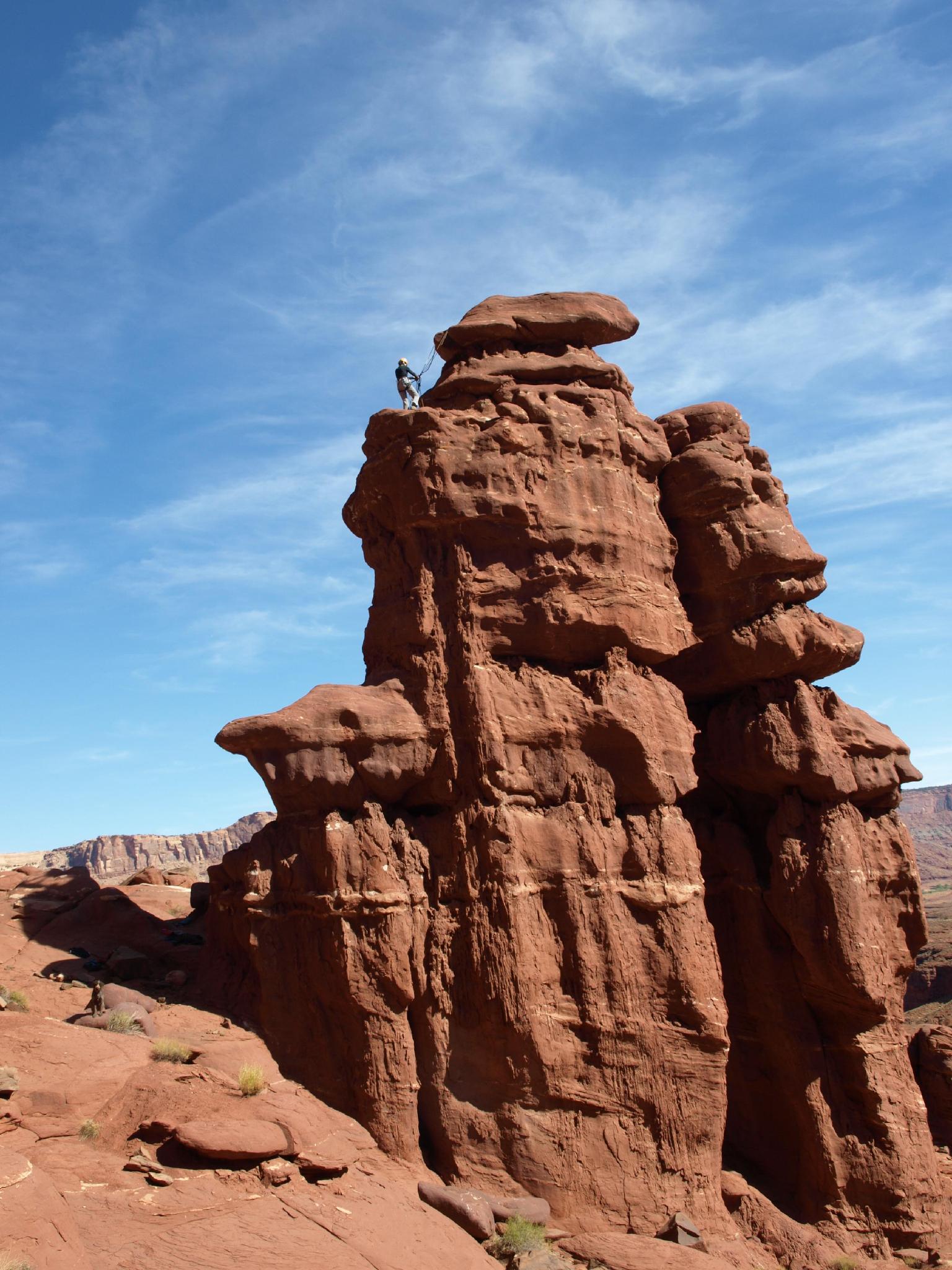
Home and Marge is a unique tower, or rather 2 towers than have leaned on each other over time. Similar, I assume in the first ascenders mind, to how Home and Marge lean on each other in a symbiotic relationship.

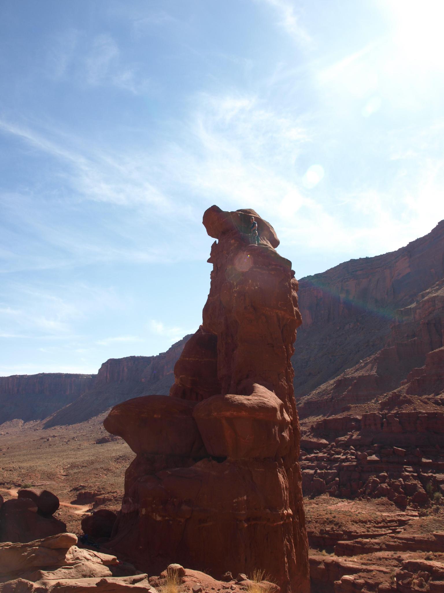
Not very interesting climbing leads to an amazing summit on a unique feature. I recommend this one!

Homer and Marge Tower - The route summits the left tower.

Homer and Marge Tower - The route summits the left tower.

Nearing the summit of Homer and Marge Tower

Nearing the summit of Homer and Marge Tower

Getting There

From downtown Moab, head to south to Kane Creek Blvd. Turn right on Kane Creek Blvd. (This is currently where the McDonald's and Burger King are.)

  • Reset odometer as you turn onto Kane Creek Blvd. ( 12S 626362mE 4269376mN / N38° 33' 50" W109° 32' 59" )
  • 2.6 miles - Moab Rim Trailhead and Pit Toilet on the left. ( 12S 623455mE 4268771mN / N38° 33' 32" W109° 34' 59" )
  • 2.7 miles - King Bottom Campground ( 12S 623368mE 4268646mN / N38° 33' 28" W109° 35' 03" )
  • 3.05 miles - Moonflower Campground / Trailhead on the left and rock art panel. ( 12S 623137mE 4268307mN / N38° 33' 17" W109° 35' 12" )
  • 3.5 - Dirt road goes off on the left and up a hill. This is the Elephant Panel Trailhead. ( 12S 622637mE 4267587mN / N38° 32' 54" W109° 35' 34" )
  • 4.0 miles - Small Sheep Rock art panel next to the road on the left. ( 12S 622334mE 4267010mN / N38° 32' 35" W109° 35' 46" )
  • 4.3 miles - Small petroglyph panel next to the road on the left. ( 12S 622112mE 4266521mN / N38° 32' 19" W109° 35' 56" )
  • 4.6 miles - Pritchett Canyon Trailhead ( 12S 622059mE 4266123mN / N38° 32' 07" W109° 35' 58" )
  • 4.7 miles - Road turns to dirt with a big parking area on the left. ( 12S 622011mE 4266036mN / N38° 32' 04" W109° 36' 00" )
  • 5.1 miles - Small parking area and trail going up to a panel on the left. ( 12S 622546mE 4265578mN / N38° 31' 49" W109° 35' 39" )
  • 5.3 miles - Large parking area on the right. This is the False Kiva Trailhead, and also the Amasa Back Trail Parking area. ( 12S 622314mE 4265360mN / N38° 31' 42" W109° 35' 48" )
  • 5.8 miles - Amasa Back Trail ( 12S 621895mE 4264888mN / N38° 31' 27" W109° 36' 06" )
  • 6.1 miles - Birthing Rock on the right. Small parking area. This is also the trailhead for Map Panel. ( 12S 621821mE 4264647mN / N38° 31' 19" W109° 36' 09" )
  • 6.18 miles - Boulder with petroglyph on the right. ( 12S 621845mE 4264524mN / N38° 31' 15" W109° 36' 08" )
  • 6.2 miles - Parking are on the left just after cresting a hill and starting down the other side. This is the Funnel Arch Trailhead. ( 12S 621995mE 4264439mN / N38° 31' 12" W109° 36' 02" )
  • 6.9 miles - Spring Site Walk in Campground ( 12S 622505mE 4264245mN / N38° 31' 05" W109° 35' 41" )
  • 7.7 miles - Hunter Canyon Campground ( 12S 622319mE 4263329mN / N38° 30' 36" W109° 35' 49" )
  • 8.0 miles - Ice Cream Parlor Climbing Area on the left. ( 12S 622006mE 4263348mN / N38° 30' 37" W109° 36' 02" )
  • 9.5 miles - Ledge A Campground ( 12S 621541mE 4261386mN / N38° 29' 33" W109° 36' 23" )
  • 9.9 miles - Ledge B Campground ( 12S 621699mE 4260561mN / N38° 29' 06" W109° 36' 17" )
  • 10.2 - Happy Turk Hoodoo / Pensive Putterman ( 12S 621873mE 4260234mN / N38° 28' 56" W109° 36' 10" )
  • 10.3 miles - Ledge C Campground ( 12S 621920mE 4260107mN / N38° 28' 51" W109° 36' 08" )
  • 11.3 miles - Ledge D Campground ( 12S 622052mE 4258687mN / N38° 28' 05" W109° 36' 03" )
  • 11.4 miles - Ledge E Campground ( 12S 622055mE 4258554mN / N38° 28' 01" W109° 36' 03" )
  • 13.2 miles - Homer and Marge Trailhead ( 12S 619980mE 4258997mN / N38° 28' 16" W109° 37' 29" )
Just below the summit.

Just below the summit.

Route

Route: Chili Cook Off

The route is not visible from the road.

From the parking spot, find an easy way up the first cliff band on the west, and follow the cliff band as it parallels the road. One up the cliff band, you will see Homer and Marge to the north west shortly. With good route finding, it is an easy hike to its base. The route is on the north west side.

Start the route by climbing a 10 foot narrow crack to a ledge. This short crack is a challenge. A #5 C4 camalot fits nicely to aid this section if desired. Once on the ledge, go left, and follow the bolts up to a small ledge below the summit. At this point, switch from aid climbing to easy free climbing (5.5) to the anchors below the summit. A short boulder problem easily attains the summit. Rappel the route.


Photos

Maps

Printable Maps:
Homer and Marge Trailhead

12S 619979mE 4258997mN

N38° 28' 16" W109° 37' 29"

Homer and Marge Tower

12S 619954mE 4259091mN

N38° 28' 19" W109° 37' 30"

Comments

Want to make a comment? Login and let yourself be heard.