Cataract Gorge and Little Deer Creek Falls |

Western Uintas

Hiking Cataract Gorge and Little Deer Creek Falls - Western UintasRoadside Attraction Cataract Gorge and Little Deer Creek Falls - Western Uintas Cataract Gorge and Little Deer Creek Falls

Western Uintas

Overview

RATING: Easy Hiking
MAPS: IRON MINE MOUNTAIN, UT

Sat

A chance of snow showers before 9am, then a chance of rain and snow showers between 9am and noon, then showers and thunderstorms. Cloudy. High near 42, with temperatures falling to around 40 in the afternoon. North northwest wind 5 to 10 mph. Chance of precipitation is 90%. New snow accumulation of less than half an inch possible.

42 | 27

Sun

Snow showers likely before 3pm, then rain showers likely. Mostly cloudy, with a high near 42. Northwest wind around 10 mph. Chance of precipitation is 60%. Little or no snow accumulation expected.

42 | 26

Mon

A chance of showers and thunderstorms after noon. Mostly sunny, with a high near 47. Chance of precipitation is 30%.

47 | 24

Tue

A slight chance of rain showers after noon. Mostly sunny, with a high near 49.

49 | 26

Wed

A slight chance of snow showers before noon, then a chance of rain showers. Partly sunny, with a high near 48.

48 | 28

View Full Weather Details
SEASON: Summer, Fall
GEAR: Standard Hiking Gear
WATER: Filterable

Sat

A chance of snow showers before 9am, then a chance of rain and snow showers between 9am and noon, then showers and thunderstorms. Cloudy. High near 42, with temperatures falling to around 40 in the afternoon. North northwest wind 5 to 10 mph. Chance of precipitation is 90%. New snow accumulation of less than half an inch possible.

42 | 27

Sun

Snow showers likely before 3pm, then rain showers likely. Mostly cloudy, with a high near 42. Northwest wind around 10 mph. Chance of precipitation is 60%. Little or no snow accumulation expected.

42 | 26

Mon

A chance of showers and thunderstorms after noon. Mostly sunny, with a high near 47. Chance of precipitation is 30%.

47 | 24

Tue

A slight chance of rain showers after noon. Mostly sunny, with a high near 49.

49 | 26

Wed

A slight chance of snow showers before noon, then a chance of rain showers. Partly sunny, with a high near 48.

48 | 28

View Full Weather Details
The pools in Cataract Gorge

The pools in Cataract Gorge

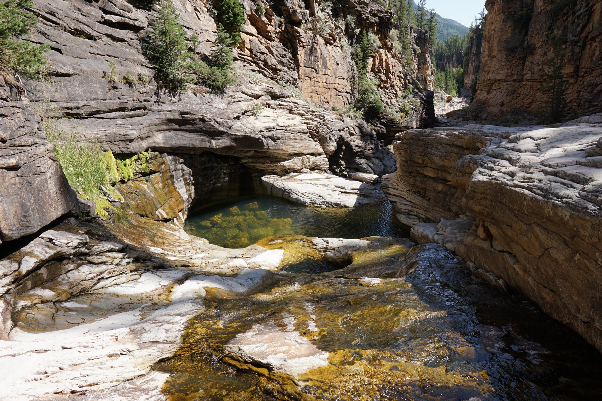
Cataract Gorge is one of the most dramatic and stunning spots in the Uinta Mountains. There are many hikes in the Uintas that have excellent views of peaks or lakes high above treeline. Cataract Gorge, with its beautiful crystal clear pools and falls, is one of my personal favorites even without the big mountain views. Little Deer Creek Falls, just above Cataract Gorge is the cherry on top of the day.

VIsiting the gorge and waterfall are short, family-friendly activities and a great way to beat the summer heat. The pools make for excellent swimming holes.

Beware though of a few things:

First, the road down requires a high clearance vehicle! In typical Uinta mountains style, this is a relentlessly rocky and rough road. True 4x4 recommended. Subaru type vehicles will have a difficult or impossible time. Some walk or mountain bike the last 3 miles of the bumpy road. Walking seems reasonable as a day hike, the bikers we saw were struggling quite a bit. Likely too rough for many mountain bikers tastes.

Second, the gorge is just below the Duchesne Tunnels east portal. Until about July, the river flows entirely down the canyon and is often too high and dangerous to visit. Once diversion into the tunnel begins, and spring runoff subsides, the flow in the gorge drops dramatically. Visit in late July and onward. In fall, the river is likely to be entirely diverted and the upper canyon dry. Springs on the side keep a bit of water flowing down the falls and into the swimming holes even when the top section is dry.

Finally, the east portal has a dispersed camping area around it. The camping area consists of maybe a dozen or so fairly tightly spaced sites that will fill up on summer weekends. If planning on camping, I would recommend having a plan B in case the camping is full.

History Note: The Duchesne Tunnel was constructed in 1948, halted in 1951 because of the Korean War, then finished in 1953 and 1954. The tunnel is 10 feet in diameter and a stunning 6 miles in length. It connects the Duchesne Watershed with the Provo River watershed and allows for transferring water to the Provo from the Duchesne. The west side of the tunnel is visible just off the Mirror Lake Highway at MP 17.75. There is a pull-out and pathway down to near the river. This is just before the Duchesne Tunnel Campground.
A small cascade in the gorge.

A small cascade in the gorge.

Getting There

Note: The Mirror Lake highway that is used to access this hike is closed in the winter. The gate is typically open from Memorial Day until late October, but if planning this hike on the shoulder season, call the forest service to see if it is open. ((801) 466-6411)

From Kamas, head east on UT-150 (Mirror Lake Highway) for about 21.5 miles to mile post 21.5. The Murdock Basin road leaves the Mirror Lake Highway here on the right as a wide road. It was unsigned on our last visit. Reset your odometer as you turn off the highway.

  • Murdock Turnoff ( 12T 503362mE 4497286mN / N40° 37' 35" W110° 57' 37" )
  • 2.1 miles - Continue on main road after crossing a large camping/atv area. ( 12T 505684mE 4497955mN / N40° 37' 57" W110° 55' 58" )
  • 2.5 miles - Jct- Right - Road gets much rougher as it begins descending. ( 12T 506267mE 4498098mN / N40° 38' 01" W110° 55' 33" )
  • 5.3 miles - Side road (camping) stay right. This is the beginning of the dispersed camping spots. ( 12T 509170mE 4497302mN / N40° 37' 35" W110° 53' 30" )
  • 5.6 milea - Jct - Right to falls in a few hundred feet. Left to end of road and gorge trailhead. ( 12T 509181mE 4496828mN / N40° 37' 20" W110° 53' 29" )
Diane and Ruby checking out the geology.

Diane and Ruby checking out the geology.

Route

From the end of the road, the gorge is visible to the south. A social trail leaves from the parking area bypassing the first part of the gorge, or head down from the start of the gorge.

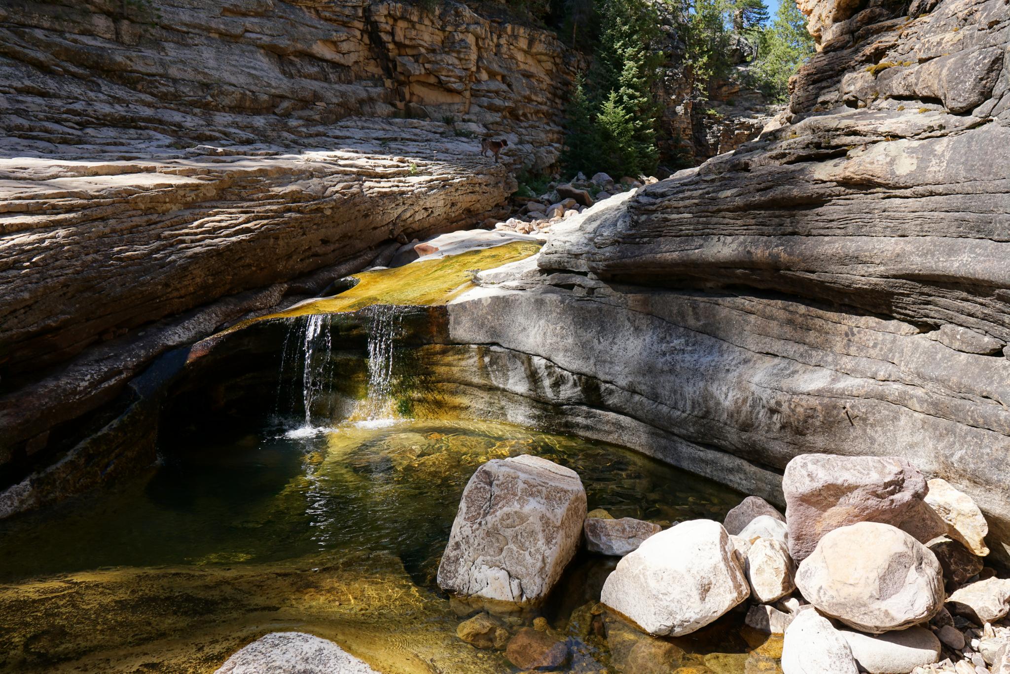
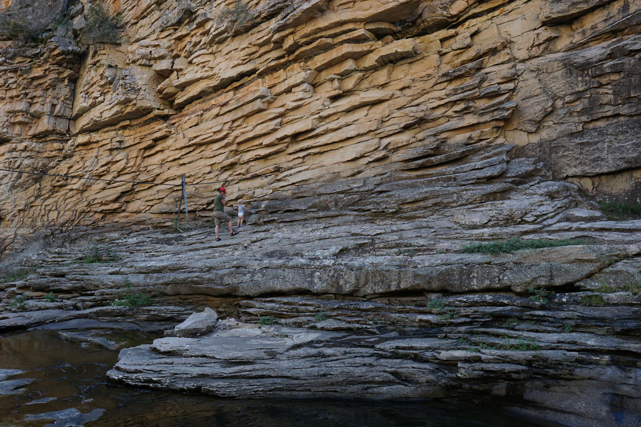
The going is rocky but easy. About 5-10 minutes down from the trailhead is the idyllic pool section where several small waterfalls and cascades drop into large crystal clear pools. The pools are the destination for most. An old cable is strung across the canyon below the pools — a likely relic of when the tunnel was built.

Note: Continuing down the gorge is less interesting than this section. It gradually opens a bit, then the walls quickly lower.


Maps

Route / 0.88 miles / Elevation Range 8,031 - 8,172 ft.
Printable Maps:
Trailhead

12T 509262mE 4496839mN

N40° 37' 20" W110° 53' 26"

Falls

12T 509138mE 4496782mN

N40° 37' 19" W110° 53' 31"

Pools

12T 509315mE 4496617mN

N40° 37' 13" W110° 53' 24"

East Portal

12T 509218mE 4497114mN

N40° 37' 29" W110° 53' 28"

Comments

Want to make a comment? Login and let yourself be heard.