Sunrise/Sunset Arches |

Escalante

Hiking Sunrise/Sunset Arches - Escalante Hiking Sunrise/Sunset Arches

Escalante

Overview

RATING: Easy hiking
MAPS: King Mesa, UT; Sooner Bench, UT

Tue

Sunny, with a high near 61. Southeast wind around 6 mph.

61 | 36

Wed

Sunny, with a high near 67. West southwest wind 3 to 7 mph.

67 | 38

Thu

Sunny, with a high near 69.

69 | 39

Fri

Sunny, with a high near 69.

69 | 44

Sat

Sunny, with a high near 67.

67 | 44

View Full Weather Details
SEASON: Any, although summers can be hot, and the roads difficult when wet or snowy.
GEAR: Standard Hiking Gear

Tue

Sunny, with a high near 61. Southeast wind around 6 mph.

61 | 36

Wed

Sunny, with a high near 67. West southwest wind 3 to 7 mph.

67 | 38

Thu

Sunny, with a high near 69.

69 | 39

Fri

Sunny, with a high near 69.

69 | 44

Sat

Sunny, with a high near 67.

67 | 44

View Full Weather Details
Sunset Arch

Sunset Arch

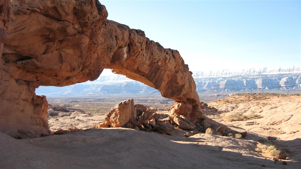
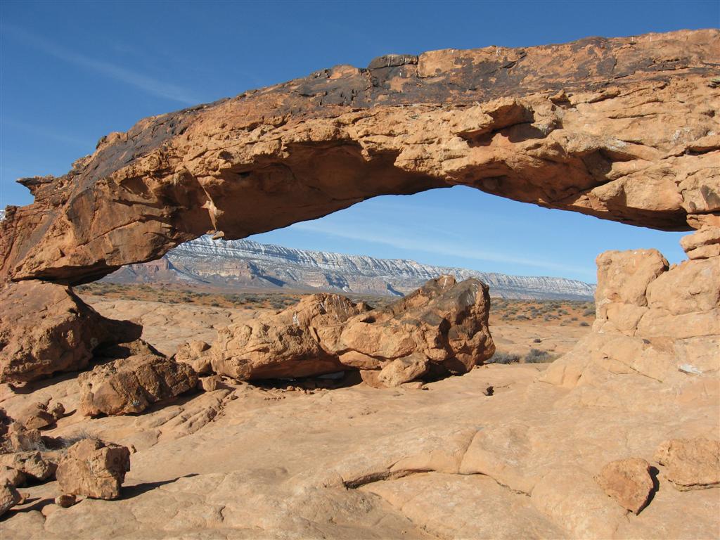
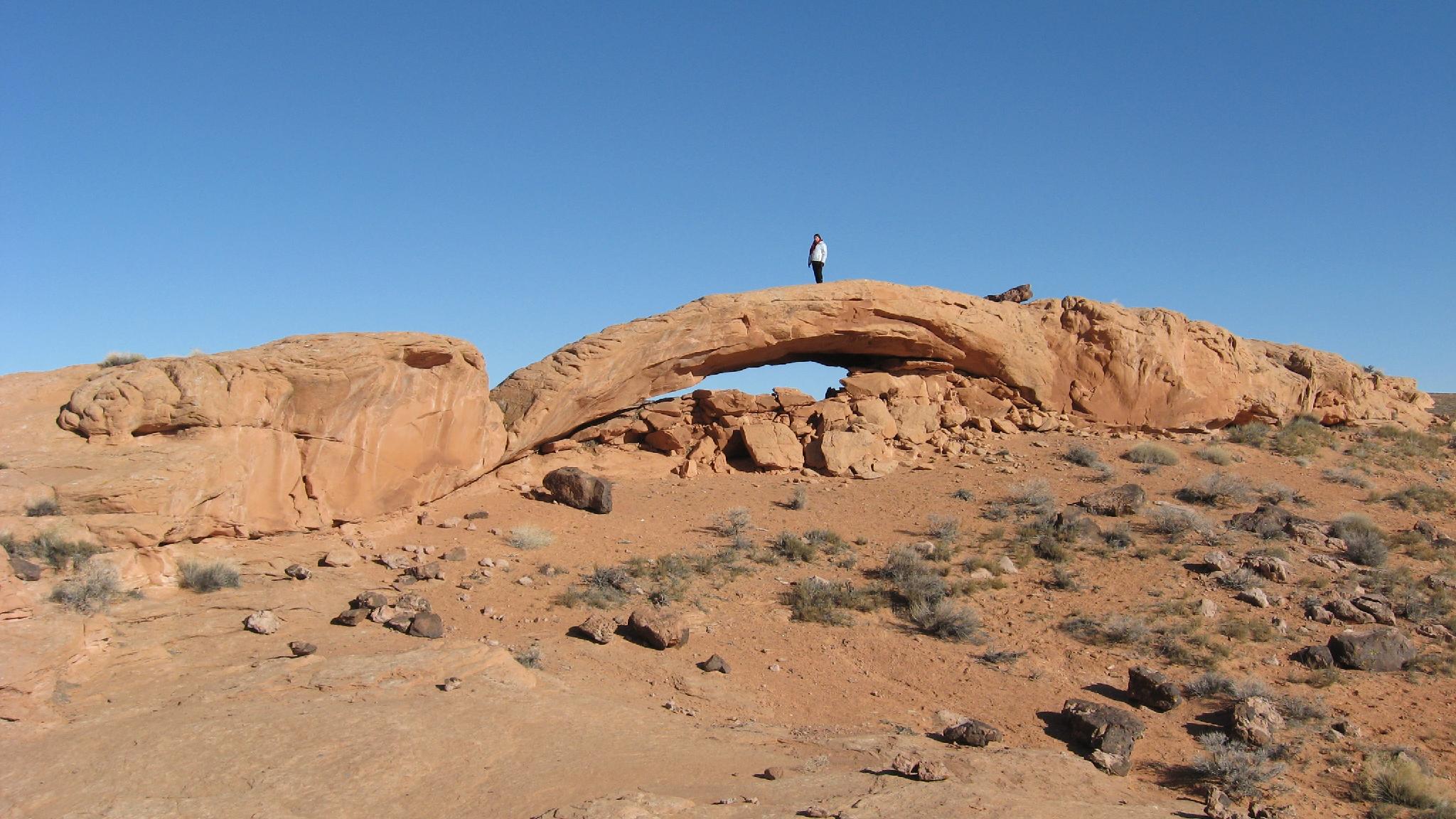
Are you a bit of an arch bagger? This short hike visits two very different arches. Sunset arch appears to be an Entrada sandstone arch while within sight of it, several hundred meters away, sits Sunrise arch in a different sandstone layer altogether.

Surprisingly, given the distance down the Hole-In-The-Rock road needed to reach the trailhead, you often see these arches photographed in calendars and magazines. I think evening light is particularly dramatic for photographs.

Sunset Arch

Sunset Arch

Getting There

Head east out of the town of Escalante about 5 miles on highway 12 until the well signed Hole in the Rock road on the south side of highway 12. Reset the odometer as you turn onto this road.

  • Mile 0 - Hole-In-The-Rock Road Turnoff ( 12S 453167mE 4175716mN / N37° 43' 39" W111° 31' 53" )
  • 8.0 miles - Parking area after a cattle guard. This is the Zebra/Tunnel trailhead. ( 12S 460681mE 4165896mN / N37° 38' 22" W111° 26' 44" )
  • 12.3 miles - Devil's Garden turn off on the right. The trailhead is about 1/4 of a mile down this road. No camping, but a pit toilet. ( 12S 463808mE 4160175mN / N37° 35' 17" W111° 24' 36" )
  • 16.6 miles - Egypt road on the left. This access the Egypt and Neon trailheads ( 12S 468045mE 4154960mN / N37° 32' 28" W111° 21' 42" )
  • 24.8 miles - Upper Dry Fork Trailhead on the right (south). This has a large parking area and pit toilet. ( 12S 478657mE 4148035mN / N37° 28' 44" W111° 14' 29" )
  • 26.1 miles - Dry Fork Trailhead Road on the left (north). The trailhead is at the end of the road in about a mile. ( 12S 480198mE 4146661mN / N37° 27' 60" W111° 13' 26" )
  • 30.9 miles - Red Well side road on the left. Follow this 1 mile to its end for the Red Well Trailhead. ( 12S 485669mE 4141593mN / N37° 25' 16" W111° 09' 43" )
  • 33.1 miles - Chimney Rock side road on the left (north). ( 12S 487309mE 4138502mN / N37° 23' 36" W111° 08' 36" )
  • 34 miles - Hurricane Wash Trailhead on the left. ( 12S 488275mE 4137666mN / N37° 23' 08" W111° 07' 57" )
  • 36.3 miles - Fortymile Ridge side road on the left. This road goes to the Stock Tank and Fortymile Ridge trailheads commonly used for Coyote Gulch. This is also the road to Sunset Arch. ( 12S 489827mE 4135057mN / N37° 21' 44" W111° 06' 54" )
  • Fortymile Ridge Side Road - Reset your odometer as you turn off the Hole-In-The-Rock road. This side road is generally passable by most to the Stock Tank trailhead. It requires 4wd to reach the Fortymile Trailhead due to deep sand. A few side road leave, stay on the main most used side road until junctions are described. ( 12S 489832mE 4135059mN / N37° 21' 44" W111° 06' 53" )
  • Fortymile Side Road - 4.4 miles - Junction. A steep road on the left climbs to the Water Tank TH and small parking area used for the Jacob Hamblin Arch route into Coyote Gulch. This is also the parking spot for Sunrise/Sunset Arches which are south of the trailhead. ( 12S 495698mE 4138318mN / N37° 23' 30" W111° 02' 55" )
Cristina on one of the arches.

Cristina on one of the arches.

Route

From the trailhead, hike back down to the junction with 40 Mile Ridge Road. Look south toward 50 Mile Mountain and the Hole in the Rock road. On the left, off in the distance, is Cave Point. Head across the sagebrush flat for about 20 minutes toward Cave Point until you are close to some small hoodoos and towers. Just before those hoodoos and towers, you can see a slickrock area to the south. The two arches are visible when you reach this area. (30-40 minutes from the car to the arches.)

Return the way you came. By parking on the small hill, you can see your vehicle for most of the return.


Maps

Route / 2.55 miles / Elevation Range 4,520 - 4,797 ft.
Printable Maps:
Trailhead

12S 495706mE 4138452mN

N37° 23' 34" W111° 02' 55"

Sunset Arch

12S 495711mE 4136624mN

N37° 22' 35" W111° 02' 54"

Sunrise Arch

12S 495803mE 4136239mN

N37° 22' 22" W111° 02' 51"

Comments

Want to make a comment? Login and let yourself be heard.