Happy Turk Hoodoo | Kane Creek

Climbing Happy Turk Hoodoo - Kane Creek Climbing Happy Turk Hoodoo

Kane Creek

Overview

RATING: 5.8 C1
LENGTH: 1-2 hours
MAPS: None Needed.

Sat

Areas of smoke before 11am. Sunny, with a high near 92. South southwest wind 10 to 15 mph, with gusts as high as 30 mph.

92 | 73

Sun

Sunny, with a high near 94. South southwest wind 5 to 10 mph, with gusts as high as 25 mph.

94 | 68

Mon

Mostly sunny, with a high near 98.

98 | 70

Tue

Mostly sunny, with a high near 95.

95 | 74

Wed

A slight chance of showers and thunderstorms after noon. Mostly sunny, with a high near 94.

94 | 72

View Full Weather Details
SEASON: Any, hot in summer.
GEAR: 50 m ( 165 ft. ) Rope – Quick draws (6-8) – Stick Clip, aid gear

Sat

Areas of smoke before 11am. Sunny, with a high near 92. South southwest wind 10 to 15 mph, with gusts as high as 30 mph.

92 | 73

Sun

Sunny, with a high near 94. South southwest wind 5 to 10 mph, with gusts as high as 25 mph.

94 | 68

Mon

Mostly sunny, with a high near 98.

98 | 70

Tue

Mostly sunny, with a high near 95.

95 | 74

Wed

A slight chance of showers and thunderstorms after noon. Mostly sunny, with a high near 94.

94 | 72

View Full Weather Details
Making some of the final moves.

Making some of the final moves.

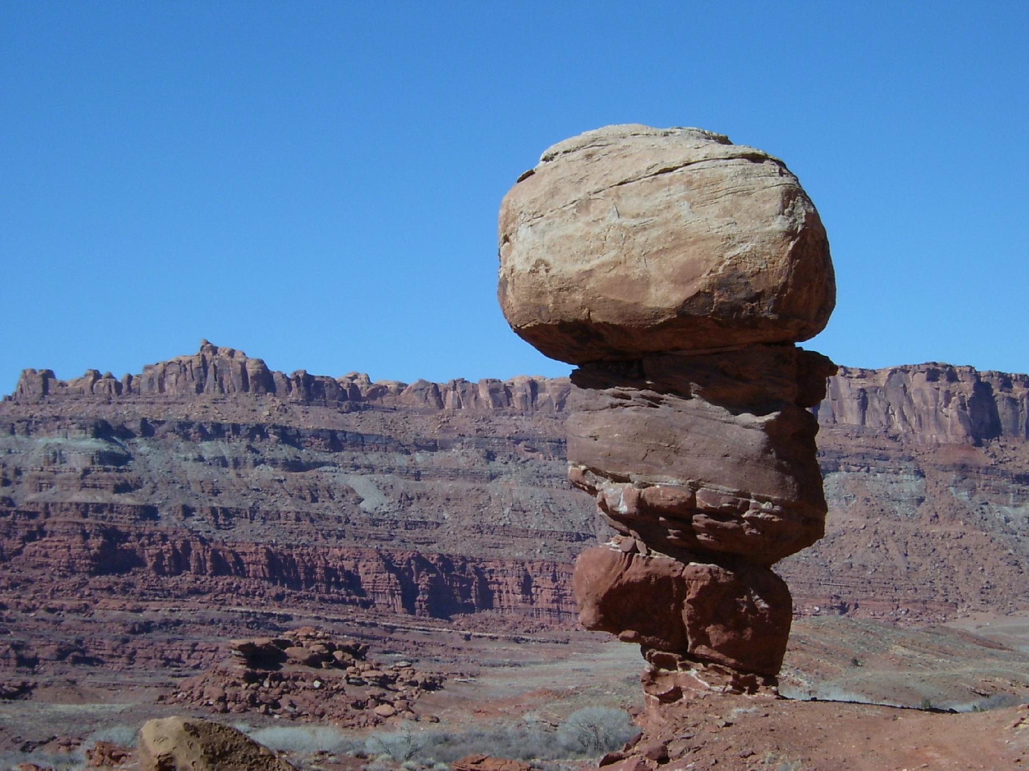
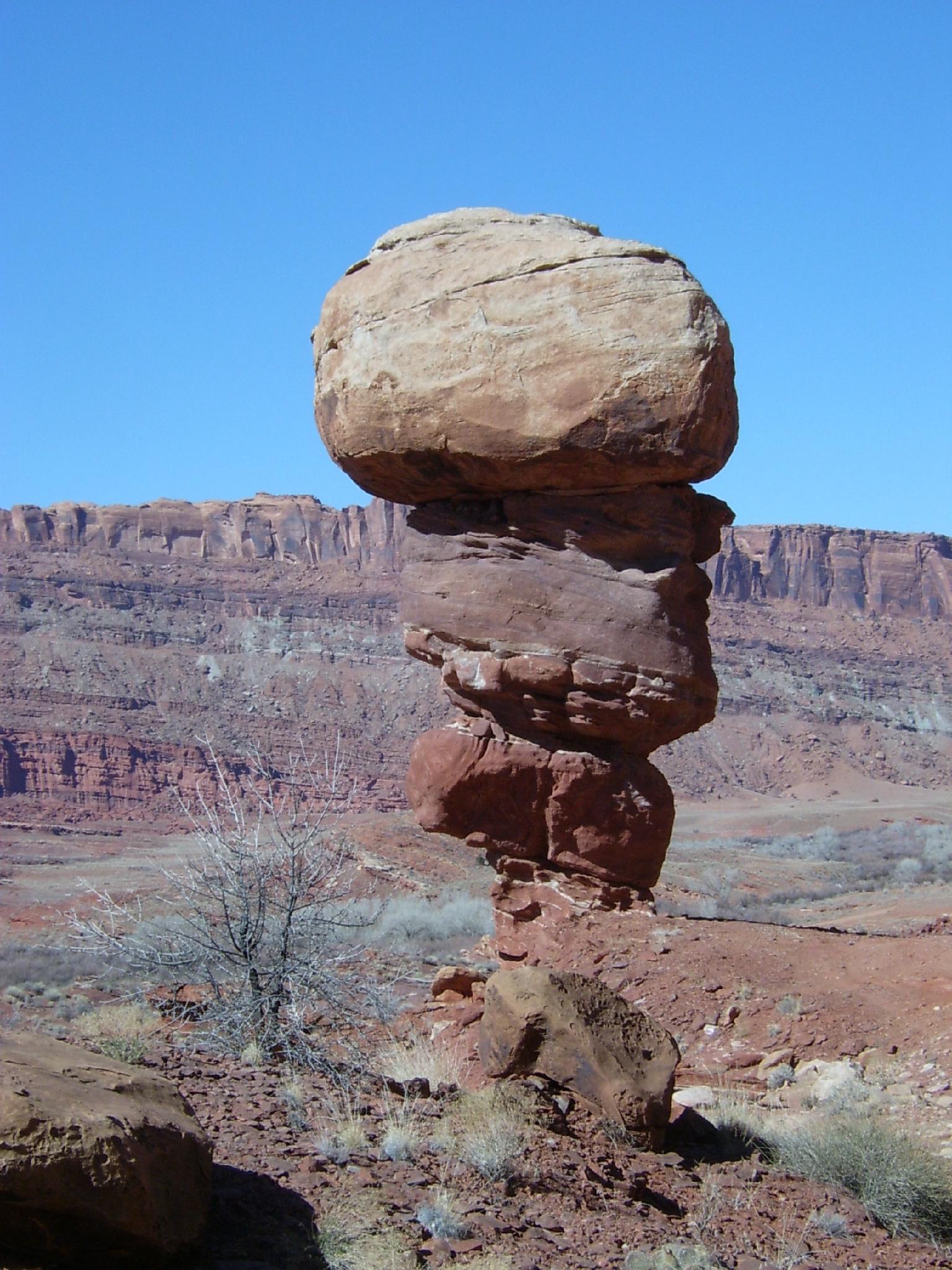
One of the more outlandish moderate routes around Moab, Happy Turk Hoodoo is an easy aid route up a photogenic ice cream cone shaped tower. It is also known as the Golf Ball for obvious reasons.

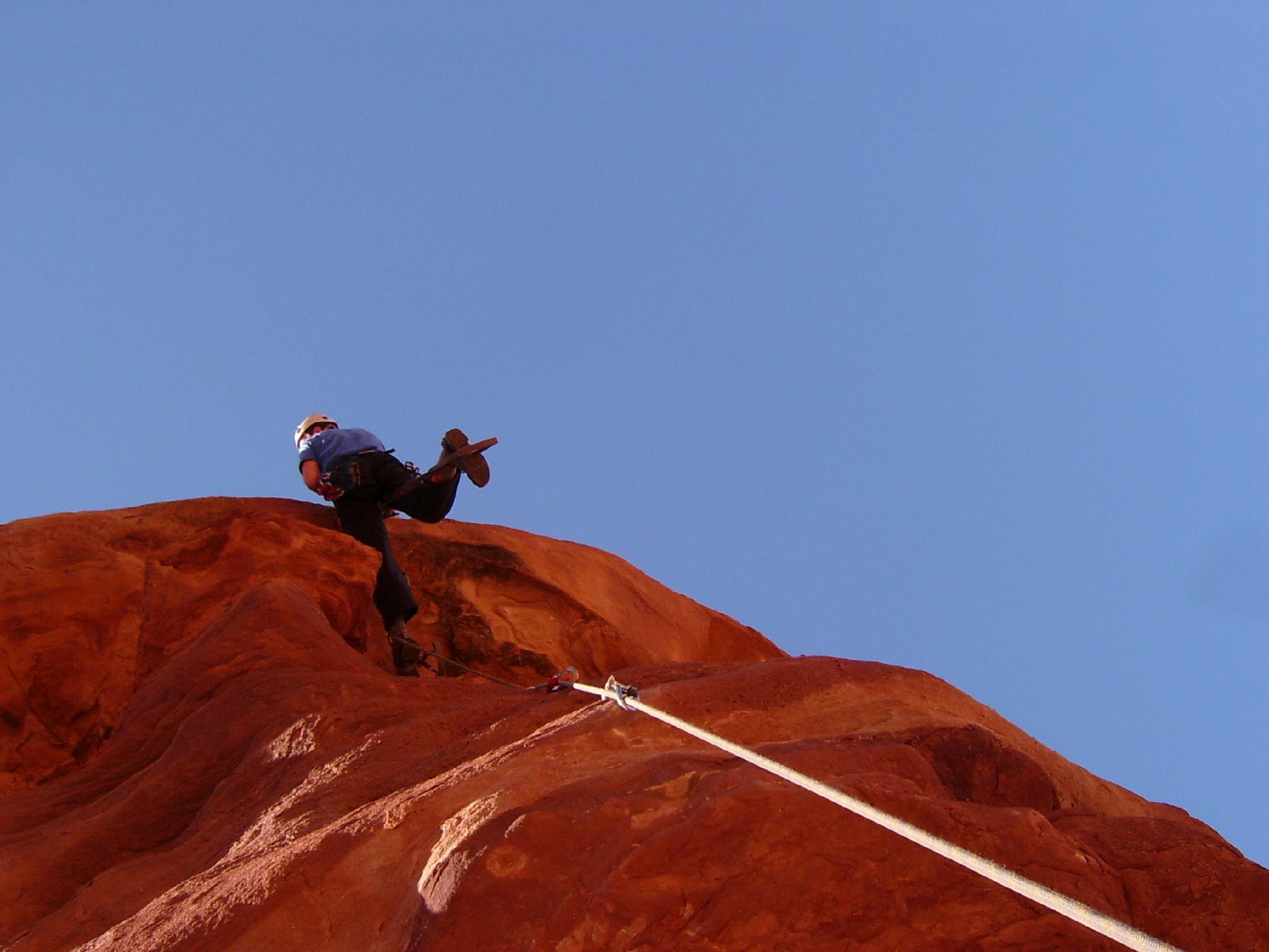
This one is photogenic and fun! The route is essentially a bolt ladder, C1, though some trickery might be involved in clipping the first bolt as it is a bit high, and there is a little free climbing at the top.

Do this one before the tower eventually falls down in a year, 10 years, 1000 years, who knows....

Happy Turk Hoodoo - Kane Creek

Happy Turk Hoodoo - Kane Creek

Getting There

From downtown Moab, head to south to Kane Creek Blvd. Turn right on Kane Creek Blvd. (This is currently where the McDonald's and Burger King are.)

  • Reset odometer as you turn onto Kane Creek Blvd. ( 12S 626362E 4269376N / 38°33'50"N 109°32'59"W )
  • 2.6 miles - Moab Rim Trailhead and Pit Toilet on the left. ( 12S 623455E 4268771N / 38°33'32"N 109°34'59"W )
  • 2.7 miles - King Bottom Campground ( 12S 623368E 4268646N / 38°33'28"N 109°35'03"W )
  • 3.05 miles - Moonflower Campground / Trailhead on the left and rock art panel. ( 12S 623137E 4268307N / 38°33'17"N 109°35'12"W )
  • 3.5 - Dirt road goes off on the left and up a hill. This is the Elephant Panel Trailhead. ( 12S 622637E 4267587N / 38°32'54"N 109°35'34"W )
  • 4.0 miles - Small Sheep Rock art panel next to the road on the left. ( 12S 622334E 4267010N / 38°32'35"N 109°35'46"W )
  • 4.3 miles - Small petroglyph panel next to the road on the left. ( 12S 622112E 4266521N / 38°32'19"N 109°35'56"W )
  • 4.6 miles - Pritchett Canyon Trailhead ( 12S 622059E 4266123N / 38°32'07"N 109°35'58"W )
  • 4.7 miles - Road turns to dirt with a big parking area on the left. ( 12S 622011E 4266036N / 38°32'04"N 109°36'00"W )
  • 5.1 miles - Small parking area and trail going up to a panel on the left. ( 12S 622546E 4265578N / 38°31'49"N 109°35'39"W )
  • 5.3 miles - Large parking area on the right. This is the False Kiva Trailhead, and also the Amasa Back Trail Parking area. ( 12S 622314E 4265360N / 38°31'42"N 109°35'48"W )
  • 5.8 miles - Amasa Back Trail ( 12S 621895E 4264888N / 38°31'27"N 109°36'06"W )
  • 6.1 miles - Birthing Rock on the right. Small parking area. This is also the trailhead for Map Panel. ( 12S 621821E 4264647N / 38°31'19"N 109°36'09"W )
  • 6.18 miles - Boulder with petroglyph on the right. ( 12S 621845E 4264524N / 38°31'15"N 109°36'08"W )
  • 6.2 miles - Parking are on the left just after cresting a hill and starting down the other side. This is the Funnel Arch Trailhead. ( 12S 621995E 4264439N / 38°31'12"N 109°36'02"W )
  • 6.9 miles - Spring Site Walk in Campground ( 12S 622505E 4264245N / 38°31'05"N 109°35'41"W )
  • 7.7 miles - Hunter Canyon Campground ( 12S 622319E 4263329N / 38°30'36"N 109°35'49"W )
  • 8.0 miles - Ice Cream Parlor Climbing Area on the left. ( 12S 622006E 4263348N / 38°30'37"N 109°36'02"W )
  • 9.5 miles - Ledge A Campground ( 12S 621541E 4261386N / 38°29'33"N 109°36'23"W )
  • 9.9 miles - Ledge B Campground ( 12S 621699E 4260561N / 38°29'06"N 109°36'17"W )
  • 10.2 - Happy Turk Hoodoo / Pensive Putterman ( 12S 621873E 4260234N / 38°28'56"N 109°36'10"W )
Happy Turk Hoodoo in Kane Creek

Happy Turk Hoodoo in Kane Creek

The rappel rope.

The rappel rope.

Route

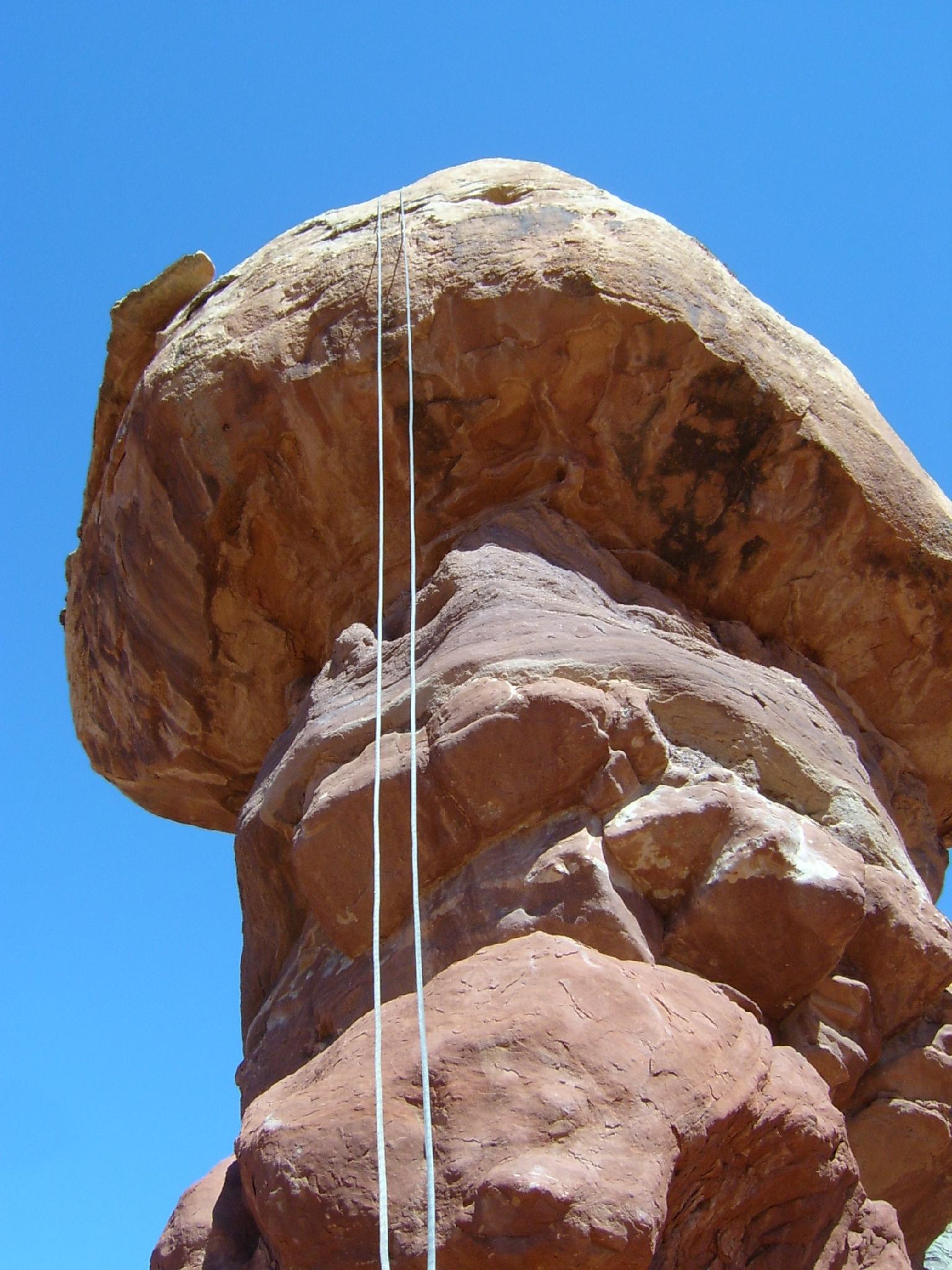
The original way to clip the first bolt involved driving close to the base of the tower, standing on your car roof, and stretching to reach the first clip. The road, however, has now been closed. Now you'll need to stick clip it from the ground. This is likely the crux, as the bolts use chain links instead of hangers, so clipping is tricky. It goes free at hard 5.11 if you don't want to stick clip.

However you get the first bolt clipped, just follow the bolt line to the top. Several bolts are spaced a bit and require top stepping or a good reach. A couple of free moves guard the top. Rock climbing shoes are recommended to make these moves. Rappel from bolts on top.


Maps

Printable Maps:

Happy Turk Hoodoo

12S 621998E 4260297N

38°28'58"N 109°36'05"W

Comments

Want to make a comment? Login and let yourself be heard.