 Canyoneering
Medieval Chamber
Canyoneering
Medieval Chamber
Moab
Overview
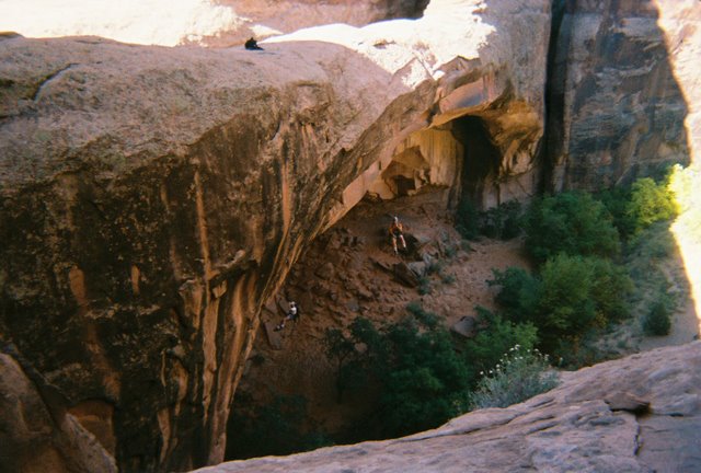
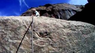
Medieval Chamber is a short route just outside of Moab. Although not very long, it is renowned for its last rappel, which can be done as a simul rap off an arch. The last rappel, Morning Glory Arch, is very popular with tourists, so expect a crowd awaiting your dramatic entrance from above.
There are several possible exits: the full route down Grandstaff Canyon, a loop UP Grandstaff Canyon, or a spicy and fun climbers only exit. If you have two cars, down Grandstaff is my recommendation as it is scenic and a really nice way to end the day. Without two cars, UP Grandstaff makes a nice loop as well.
Getting There
From downtown Moab, turn left (east) on Millcreek road, and follow it to the Sand Flats road. Take the Sand Flats road, passing the pay booth and slickrock biking trail. 1.5 miles past the biking trail, the road crosses a wash. This is the wash you will be traveling down. Park your car off the road anywhere near here. The radio tower group area is just before the wash.
Optional Shuttle
If you have 2 cars, and would like to do the shuttle, leave one car at the Grandstaff Canyon trailhead. It is reached by heading north out of Moab about a mile, and turning right on Highway 128. Go up Highway 128 about 3 miles to the obvious and signed Grandstaff trailhead on the right. The Grandstaff trailhead was recently improved. Note: This is the preferred option for most groups. The climb out without the shuttle requires climbers or experienced canyoneers only.
Route Description
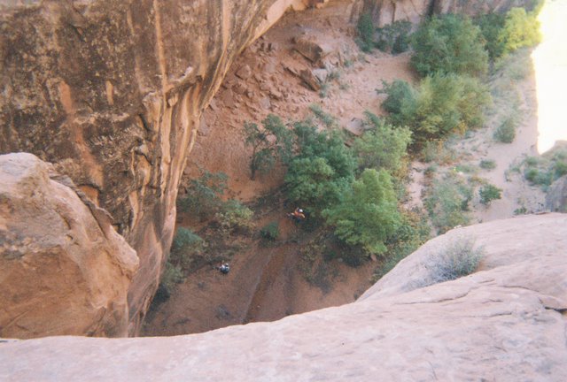
From the trailhead, walk north down the wash. Many side drainages will come in, and you will have to skirt around a few dryfalls. Nothing very difficult, keep winding your way downstream. About 30-45 minutes from the car, the canyon will plummet into the Medieval Chamber at a 30 m / 100' drop with a hanging pool 3/4 of the way down. Two bolts on the left (LDC) can be used for the anchor.
Once at the bottom, a 50 m ( 165 ft. ) section of slot leads to a wide open view down into Granstaff Canyon, and the final obstacle, a 35 m ( 115 ft. ). You have two choices:
Option 1:
A tree on the left can provide a good anchor. Bring plenty of webbing, it is a ways back from the edge. If rapping from webbing extended to the edge, a 60 m ( 197 ft. ) rope is enough.
Option 2:
Most will be here for option 2, the simultaneous rappel off the arch. I won't go into details, but this exercise is for highly experienced canyoneers only! Be careful if doing the simultaneous rappel option.
Getting out there are three options: If you spotted a car at the Grandstaff Trailhead, simply walk down from the arch to the junction with Grandstaff Canyon, turn left, and head downstream about 2 miles to your car.
UP Grandstaff Canyon Loop Exit:
From the bottom of the rappel, head down canyon to the confluence with Grandstaff Canyon. Go right (up canyon), following the most used social trail, keeping an eye on your watch. In about 1.1 miles (20-30 minutes) of easy hiking, after the canyon has made a gentle bend south, then another bend back east, keep an eye out on the right for the only reasonable looking weakness leading to the rim.
Work up the gully and weakness (no scrambling required) to the rim of the canyon. From the rim, CAREEFULLY pick your way around the cryptobiotic soil heading south and a touch west on an emerging social trail. The trail meets up with an old 4wd road. Follow it south, staying straight at the two junction, to where it re-joins the approach wash. Go left up the wash a few minutes to the trailhead.
Climbers Route Out:
Experienced canyoneers or climbers only. Climbing shoes or sticky approach shoes help.
If you don't have a shuttle, head down from the last rappel keeping a close eye on the right for the first reasonable looking place to climb out (5-10 minutes).
The climb out is at a series of 3 fins that climb out just down canyon from a side/fault canyon on the right. The 3 fins are separated each by a shallow groove and get steeper as you go down canyon, You want to ascend the middle of the three fins. There is some exposure on the climb out, and a bit of slab climbing in it. (5.4)
Be careful on the rib, there is little room for error, and a fall would be bad. Once you reach the top of the fin, you can circle up left and around to the top of the mesa. As you head back, you will find a 4x4 road that provides easy access to a nice overlook of Morning Glory Arch. Follow the 4x4 road back to the main road and your car, or the approach wash and follow the approach was back to your car.
Maps

12S 631759E 4271695N
38°35'02"N 109°29'14"W
12S 629928E 4272616N
38°35'33"N 109°30'29"W
12S 629862E 4272892N
38°35'42"N 109°30'32"W
12S 627649E 4274526N
38°36'36"N 109°32'02"W
12S 630928E 4273400N
38°35'58"N 109°29'47"W
12S 630972E 4272860N
38°35'40"N 109°29'46"W
12S 630955E 4272712N
38°35'36"N 109°29'47"W
12S 630954E 4272626N
38°35'33"N 109°29'47"W
12S 631137E 4272147N
38°35'17"N 109°29'39"W