 Canyoneering
Neon Canyon
Canyoneering
Neon Canyon
Escalante
Overview
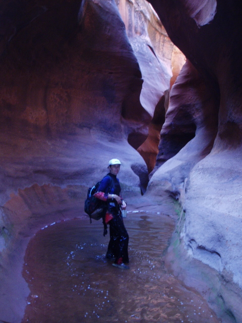
Neon, and more specifically the Golden Cathedral, may be one of the most photographed spots in Escalante. The last rap into the cathedral is amazing, but the canyon above is equally beautiful. Neon Canyon is one not to miss.
Hikers without technical canyoneering skills can hike up the bottom of Neon to visit the Golden Cathedral and return the same way. Though this makes a long hike, I recommend it as the area is stunning and the Cathedral a unique and awe-inspiring place.
Getting There
Head east out of the town of Escalante about 5 miles on highway 12 until the well signed Hole in the Rock road.
Route Description
Approach To The Bottom of Neon (3 miles / 1-1.5 hours)
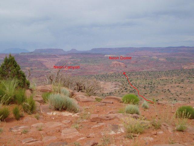
From the trailhead, locate the dome just to the right of Neon Canyon off in the distance (consult map/pictures below). Aim for the dome during the approach.
Find the well traveled and cairned trail heading down the slickrock to Fence Canyon. Follow this down off the initial steep slickrock, and then head cross country aiming for the dome. You will lose sight of the dome a time or two as the country dips down, but keep heading in that direction. Social trails appear off and on that you can follow. As you near the river, find a trail that drops steeply down a sand hill and deposits you just upstream from Neon Canyon. At a moderate pace, it should take 1-1.5 hours to reach the river from the car.
Approach From the Confluence (1.8 miles / 1 hour)
Next, head up Neon canyon a short distance (10-15 minutes) to a bend and the first and the only likely place to climb out on the left (LUC). There is a good trail here to follow that winds it's way up to an overlook above the river. Here the trail splits. Right parallels Neon on a bench, left continues along the bench above the Escalante River. Go right, and parallel Neon Canyon admiring the views.
A short distance up canyon from the Cathedral is a drop in point but continue along the trail to a better drop in higher up. The drop in you want will come before a major side canyon. You should contour around a small side canyon, and then see the larger canyon coming in around the bend. The easiest drop in is to work your way down to a slickrock bench above the canyon floor. Just upstream from the shallow canyon you contoured around is a crack that provides an easy downclimb to the canyon floor. (2.5-3 hours from the car).
Canyon
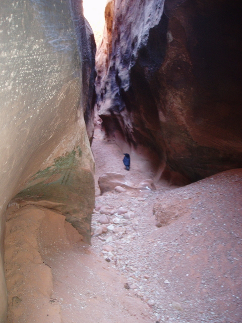
Head down Neon, suiting up at the first pool you reach. This section can have lots of wading and swimming depending on the season. The narrows are fairly shallow here, and beautiful. The canyon opens a bit in spots, then opens fairly well before a drop into a dark slot. This drop goes into a keeper pothole. If the pool is full, you can likely downclimb in, swim across, and get out. If not, you have a couple of options:
Option 1: A group of 2-3 can likely shoulder stand this obstacle. A chockstone at the top provides an anchor to rap in if needed.
Option 2: A bolt on the left, down canyon from the pothole is sometimes available, and provides a rappel in below the pothole. To access it, climb out 5 m ( 17 ft. ) UP canyon from the pothole on a slabby upclimb. Once up over the first tricky spot, it is an easy walk to the bolt. The rap length is about 8 m ( 27 ft. ).
Option 3: Highly skilled people can chimney over this pothole with big exposure and penalty points, then chimney down on the other side. (not recommended, except for the very highly skilled.)
Continue down canyon through more beautiful narrows and pools. The canyon will open a bit before a 8 m ( 27 ft. ) downclimb. This downclimb is a bit big, and can be rapped from a chockstone if people are uncomfortable with it. The narrows continue with a few easier downclimbs until you reach the final major obstacle.
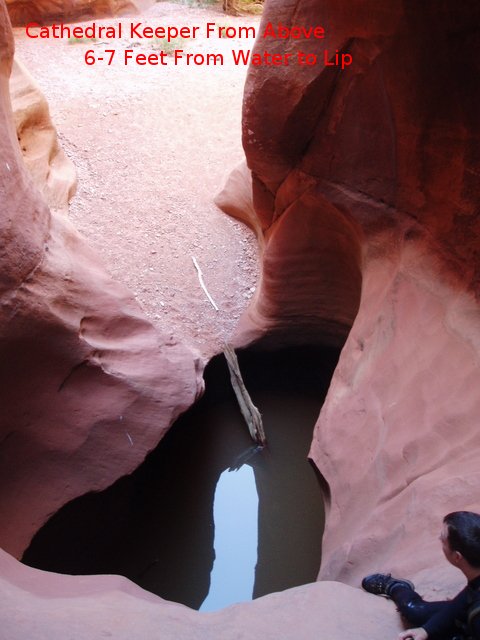
Right before the Golden Cathedral is a pothole that can range from full and a walk across to very deep and hard to exit. The down canyon side does not lend itself well to a pack toss. A group of 3 or 4 is recommended to enable partner assists if needed. In spring of 2007, we found the keeper about 2 m ( 7 ft. ) deep with a log wedged up on the side you could climb to exit the pothole. Be prepared! Getting into the pothole, in low water, is tricky, but an arch can be slung providing an anchor for a short rappel.
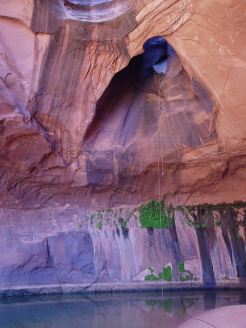
From the pothole, a short wide section leads to the final rap off a large boulder into the Cathedral. Bring 12 m ( 40 ft. ) of webbing in case this anchor needs to be replaced. The rap is about 25 m ( 83 ft. ). Coil the ropes after the rap, walk down to the Escalante River, and follow the approach trail back to the trailhead.
Photos
Videos

Neon - Sept 2018

Neon Canyon

Neon Canyon - The Edge of the Earth

Neon Canyon With Below Altitude
Maps
")
")
12S 480726E 4160733N
37°35'36"N 111°13'06"W
12S 485193E 4162222N
37°36'25"N 111°10'04"W
12S 486066E 4163885N
37°37'19"N 111°09'28"W