Trip Stats |

Boundary Canyon - Zion West Side

Back To Boundary Canyon - Zion West Side

Jump to: Quality | Ticks | Todos

Quality Ratings


Ticks


09/24/2023

07/22/2023

03/06/2023

11/29/2021
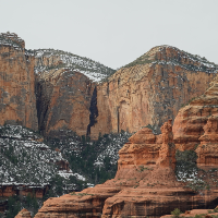
Boundary was dry and kolob was frozen Beautiful day

09/25/2021
One of the coolest canyons we have ever done!

06/08/2021
The Exit: After reaching the confluence where Boundary Canyon meets Kolob Creek (yBoundaryBt), turn right and go south down Kolob Creek. Travel down Kolob Creek from Boundary Canyon is much like hiking the narrows but without the people. The walls are high and narrow and water is flowing so plan on walking in sections of water and possibly having to wade a couple times. About 1.2 miles down stream is the start of the MIA Exit. Before getting to the MIA Exit you will go through a couple sections of very high narrow scenic slots worth admiration. The right (west) wall from Boundary to the MIA Exit is high and sheer. The MIA Exit drainage on the right (west) is the first drainage you see along the sheer west wall. If you are not paying attention it is easy to walk right on by the minor and steep looking MIA Exit drainage. There may be cairns left on large boulders here to help mark the MIA Exit. But do not count on them being there. Keep an eye on the right (west) wall on the way down Kolob Creek and you should easily be able to spot it. Finding this in the dark would be next to impossible unless you had been there before. Starting up the MIA Exit: The MIA drainage joins Kolob Creek from RDC (west) (jMIA-Exit ). The start of the MIA exit leaves Kolob Creek just upstream of a side drainage and goes up a steep dirt path along the RUC (north) side of the side drainage. The path up has a few spots of scrambling up steep dirt ledges. About 150 feet from Kolob Creek is downclimb (wMIA-RP-01) of about 15 feet down from the steep dirt path and down into the side drainage at the top of a large rock ledge. Continue west up the drainage. A short distance up will be an upclimb / scramble up of about 10 feet working from left to right. A short distance farther is an impassable dry fall of about 30 feet. Bypass this tall dry fall on the RUC (north) side up a very steep dirt slope between bushes and the canyon wall. At the top of the dirt slope go back down more steep dirt back down into the drainage above the dry fall you just bypassed. For the standard MIA exit continue west up the drainage. At the top of the 30 foot dry fall (wMIA-RP-02) after bypassing on the RUC (north) side. Continue up canyon between more narrow walls and a few short easy upclimbs / scrambles before reaching the bottom of a larger 50 foot dry fall. Note: At the apex of a steep dirt path bypassing a 30 foot dry fall is the start of an alternate MIA exit (not recommended but there). About 180 feet farther is a dry sandy chute / gully (wMIA-RP-03) on the RUC (north) side about 40 feet before reaching the bottom of a 50 foot Dry fall. If you get to the bottom of the large 50 foot dry fall, just turn around about 40 feet to find the chute. Bypass the 50 foot dryfall by climbing up the sandy chute / gully. Near the top is a large log you will need to climb under. A little over 100 feet farther is the bottom of steep dirt path (wMIA-RP-04) bypassing a 50 foot dry fall. Go up the steep path following it for about 400 feet (horizontal feet) up onto a large saddle. Note: if you get to the bottom of a 50 foot dry fall, turn back about 40 feet to the steep sandy chute. About 300 feet farther the route tops out on a saddle (wMIA-RP-05) with rocky out croppings on each side you have good views west over the next section of the exit. From the saddle you can see the Pipe Springs Canyon (aka MIA Slot) along the wall ahead and to the left (south) about 500 feet away. To the right of Pipe Springs Canyon is the final off trail climb of the exit. There used to be a set of 3 dead trees to help identify the top out but 2 of them have since fallen. From the saddle follow a path west down moderate slopes and continue following well worn paths veering left (south) down into a larger drainage below. Once down in that larger drainage, turn right and follow the large drainage west along the canyon wall a few hundred feet up to the bottom of Pipe Springs Canyon (MIA Slot). View from the saddle. This is a view from the saddle and some labels for what you will be looking for. NOTE:: As of 2020 there is only one large dead tree as the other 2 have fallen over. From the bottom of Pipe Spring Canyon (yPipeSpringBt), turn left and start northwest up the drainage. About 200 feet farther is a fork (wMIA-RP-06) in drainage as you go up the MIA Exit. At this fork look to the left (south) of the left fork to find then follow up a steep use trail up to the west. The trail roughly follows the side of the left fork of the drainage going up steep dirt slopes through vegetation. After about 300 feet the use trails level off slightly and become more easily traveled along the base of the cliff wall. Once on better trail near the base of the cliff wall, continue up about 250 more feet to where the trail crosses over the large drainage you have been roughly following. Note: From this fork up to the dirt roads above is about 650 feet of elevation gain over about 1000 horizontal feet. The first 300 feet is steep and as of 2020 is beginning to erode significantly into sections of steep soft sand. As the use trail crosses (wMIA-RP-07) a shelf in the drainage / ravine to the other side. Looking up from here you will see the sheer rock wall of the canyon then a prominent rock outcropping slightly to the right up near the rim. The view may be obscured by trees so keep an eye out. To the right of the rock out cropping is a tall dead tree. After crossing the ravine continue west up the steep hill in thicker vegetation and much less obvious use trail. There is no one best way up this last 450 feet of steep loose hill side. Be very careful of loose rock and sandy ledges. Note: In years past there used to be 3 tall dead trees you could see up on the rim, which made for a great landmark. As of 2020 two of the trees have fallen and there is now just one tall dead tree making the landmark less noteworthy. View of approx last part of the climb. This is a view of the out cropping and the approximate route up the last part of the climb. Once up on the large well graded dirt road (jMIA-climb/rd) turn left walking south up the well graded dirt road for about 360 feet to find an old no longer used road on the right (west). Note: There are multiple ways through the web of roads back to the West Rim Trailhead. The route described is the most direct route. Once you find the old not well used road (wMIA-RP-08) going up the hill to the right (west), turn right and leave the main dirt road and walk west up the semi steep not well used road. About 200 feet up the old side road is a bend in the road (wMIA-RP-09), follow the bend to the right and continue north up the road. About 425 feet farther is another bend in the road (wMIA-RP-10), follow the bend to the left and travel up the road to the northwest. A little over 500 feet farther is a fork in the road (wMIA-RP-11), stay straight (right) and continue up the road to the northwest. Do not turn left onto the side road going south. About 0.2 miles up the road is a junction (wMIA-RP-12), stay straight (right) and continue up the road to the northwest. Do not turn left onto the side road going south. About 0.2 miles up the road is gate nailed to a tree with Top King welded into it (wMIA-RP-13), continue northwest up the road. Note: This gate also marks the park boundary. To the west toward the West Rim Trailhead is in the park. Another 0.2 miles is a Tee in the road (wMIA-RP-14), turn left at this tee and start down a hill to the west. About 500 farther is fork in the road (wMIA-RP-15), continue straight at this fork passing a road that joins in from the left (south east). Continue on the road a little over 1 mile back to the West Rim Trailhead.

12/07/2020

08/30/2020
Stater at 2:00 in the afternoon. 7 1/2 hours total time back to trailhead.

06/18/2020
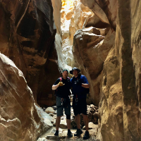
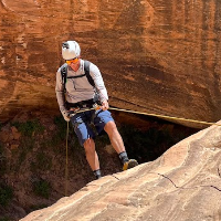
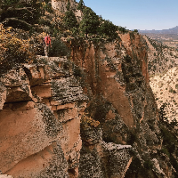
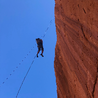
Group of 7 left St. George at 5:00am and got started on the MIA road at 7:30am using Ryan’s waypoints. Bushwhacked in a couple of miles to the entrance of the Boundary watercourse. Boundary was flowing, but definitely not a ton of water (Class B). After 11 raps through some of the most beautiful cliffs, countless waterfalls and some more bushwhacking, we eventually hit the confluence of Kolob Creek. We arrived late due to the size of our group and were a little worried that we might not have enough time to make it out of the canyon before dark, so we ate some food for about 15 minutes and hustled down the Kolob narrows (I didn’t have time to pull my camera out of the dry bag to take any pictures, so you will have to trust me…they were spectacular). The Kolob dam was releasing at 35CFS above us, so the flow was pretty strong. After exiting the narrows, we arrived at our exit point—the much maligned MIA Exit (which shockingly does not mean “Missing In Action”). A cumulative 2200 vertical feet in just over a mile and a half, most of it on all fours through some significant exposure. Back to the cars by 10:45pm. Long day and we paid the price, but totally worth it. One of the most beautiful canyons I’ve ever seen.

10/02/2019
Fun canyon. Beautiful. MIA exit marked pretty well. Not that bad. Use dirt bike to shuttle. Long road exit.

09/20/2019

09/07/2019
Boundary was totally dry, Kolob was low (one swimmer pool, but only mid-belly after a long jump with an assist). MIA trail SUCKED. Wow do not underestimate. 6.5 car to car. - took one wrong turn towards top of MIA and had to bushwhack a bit.

08/18/2019
Pine creek

08/17/2019
Boundary canyon. Beautiful. Horrible hike out.

04/14/2019
Goblins Lair

04/13/2019
Hogwarts Middle Leprechaun

04/12/2019
Lollipop of angel cove. Epic blarney.

04/11/2019
North fork of robbers roost. East fork of white roost.

06/16/2018

11/17/2017
Excellent Canyon! Crazy entrance rappel! "Journey to the center of the earth"

07/16/2017
Incredible! No wet suit needed. GPS was crucial getting to the first rap, but didn't work getting out of the canyon. Lost the MIA trail - but found our way anyway.

07/15/2017
Dry Canyon. Kolob Creek 3 cfs and stunning.

06/24/2017
Great trip. The MIA exit trail wasn't hard to follow at all. I don't think we got lost once. That being said, it's still an exhausting hike out, but I'd do it again. Or I'd camp overnight and hike out through the narrows.

04/13/2016

06/20/2015
Bone dry, and MIA exit brutal, but to be expected. One of the best I have descended in Zion.


Todos